
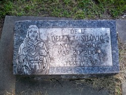
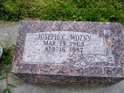
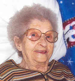
Della Louise “Dell” Wozny Silovic
| Birth | : | 4 Nov 1910 Columbus, Platte County, Nebraska, USA |
| Death | : | 20 Mar 2004 Columbus, Platte County, Nebraska, USA |
| Burial | : | Naunton Baptist Chapel, Naunton, Cotswold District, England |
| Coordinate | : | 51.9092073, -1.8356252 |
| Description | : | Daughter of Charles & Nellie (Kantor) Wozny. Married to William G. Silovic on 8-3-1940 in Chicago, IL. Occupation: Worked for the Adam's Cafe in Columbus and was a bookkeeper for Mickelberry Food Products in Chicago for 18 years retiring in 1972. |
frequently asked questions (FAQ):
-
Where is Della Louise “Dell” Wozny Silovic's memorial?
Della Louise “Dell” Wozny Silovic's memorial is located at: Naunton Baptist Chapel, Naunton, Cotswold District, England.
-
When did Della Louise “Dell” Wozny Silovic death?
Della Louise “Dell” Wozny Silovic death on 20 Mar 2004 in Columbus, Platte County, Nebraska, USA
-
Where are the coordinates of the Della Louise “Dell” Wozny Silovic's memorial?
Latitude: 51.9092073
Longitude: -1.8356252
Family Members:
Parent
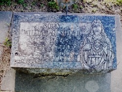
Spouse
Siblings

Flowers:


Nearby Cemetories:
1. Naunton Baptist Chapel
Naunton, Cotswold District, England
Coordinate: 51.9092073, -1.8356252
2. St Andrew's Churchyard
Naunton, Cotswold District, England
Coordinate: 51.9091340, -1.8384210
3. St Bartholomew Churchyard
Notgrove, Cotswold District, England
Coordinate: 51.8778620, -1.8426720
4. The Parish Church of St. Peter
Upper Slaughter, Cotswold District, England
Coordinate: 51.9074150, -1.7764140
5. St Mary Church
Temple Guiting, Cotswold District, England
Coordinate: 51.9510000, -1.8668000
6. All Saints Churchyard Cold Salperton
Cotswold District, England
Coordinate: 51.8771977, -1.8895386
7. St. Mary's Churchyard
Lower Slaughter, Cotswold District, England
Coordinate: 51.9018830, -1.7605380
8. St Lawrence Churchyard
Bourton-on-the-Water, Cotswold District, England
Coordinate: 51.8860500, -1.7588250
9. All Saints Churchyard
Turkdean, Cotswold District, England
Coordinate: 51.8554710, -1.8456120
10. Baptist Churchyard
Bourton-on-the-Water, Cotswold District, England
Coordinate: 51.8856973, -1.7530678
11. Water Cemetery
Bourton-on-the-Water, Cotswold District, England
Coordinate: 51.8853540, -1.7530440
12. St Mary's Churchyard
Upper Swell, Cotswold District, England
Coordinate: 51.9398030, -1.7441910
13. St. Faith's Churchyard
Winchcombe, Tewkesbury Borough, England
Coordinate: 51.9596440, -1.9119200
14. Stow-on-the-Wold Cemetery
Stow-on-the-Wold, Cotswold District, England
Coordinate: 51.9264100, -1.7254670
15. St. Edward Churchyard
Stow-on-the-Wold, Cotswold District, England
Coordinate: 51.9299810, -1.7238290
16. St. Peter's Churchyard
Little Rissington, Cotswold District, England
Coordinate: 51.8780460, -1.7262610
17. St. Andrew's Churchyard
Sevenhampton, Tewkesbury Borough, England
Coordinate: 51.8941180, -1.9539430
18. Church of St. Oswald
Compton Abdale, Cotswold District, England
Coordinate: 51.8481353, -1.9148839
19. SS Peter & Paul
Northleach, Cotswold District, England
Coordinate: 51.8295720, -1.8390300
20. St. James Churchyard
Longborough, Cotswold District, England
Coordinate: 51.9658220, -1.7407990
21. Hailes Abbey
Hailes, Tewkesbury Borough, England
Coordinate: 51.9685690, -1.9283720
22. St. Mary's Chapel Sudeley Castle
Winchcombe, Tewkesbury Borough, England
Coordinate: 51.9474550, -1.9551930
23. Hailes Chapelyard
Hailes, Tewkesbury Borough, England
Coordinate: 51.9697420, -1.9279790
24. St Paul Churchyard
Broadwell, Cotswold District, England
Coordinate: 51.9476200, -1.7095100