
| Birth | : | 12 Feb 1884 Emporia, Lyon County, Kansas, USA |
| Death | : | 9 Nov 1962 Morgan Hill, Santa Clara County, California, USA |
| Burial | : | Gavilan Hills Memorial Park, Gilroy, Santa Clara County, USA |
| Coordinate | : | 37.0124000, -121.5909200 |
| Plot | : | Sec.1, 20B Lot 2, Grave 2 |
| Inscription | : | W/O Charles |
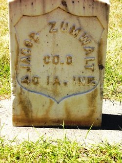
| Description | : | Della Mable Zumwalt is the daughter of Jacob Zumwalt and Tabitha Sears, the ninth of ten children. She was born in Kansas and as a young girl moved with her family to Wyoming. There she met her first husband, Emmanuel Sylvester Scott. They were married 26 Aug 1901. "Manney" and Della are the parents of ten children: Clarence, Ellis, Jennie, Irene, Hazel, Floyd, Charlie, Alfred, Charlotte and Walter. |
frequently asked questions (FAQ):
-
Where is Della Mable Zumwalt Tounsley's memorial?
Della Mable Zumwalt Tounsley's memorial is located at: Gavilan Hills Memorial Park, Gilroy, Santa Clara County, USA.
-
When did Della Mable Zumwalt Tounsley death?
Della Mable Zumwalt Tounsley death on 9 Nov 1962 in Morgan Hill, Santa Clara County, California, USA
-
Where are the coordinates of the Della Mable Zumwalt Tounsley's memorial?
Latitude: 37.0124000
Longitude: -121.5909200
Family Members:
Parent
Spouse

Siblings
Children
Flowers:


Nearby Cemetories:
1. Gavilan Hills Memorial Park
Gilroy, Santa Clara County, USA
Coordinate: 37.0124000, -121.5909200
2. Saint Mary Cemetery
Gilroy, Santa Clara County, USA
Coordinate: 37.0134300, -121.5882000
3. Saint Mary Church Cemetery
Gilroy, Santa Clara County, USA
Coordinate: 37.0155970, -121.5765950
4. Pajaro Valley Memorial Park
Watsonville, Santa Cruz County, USA
Coordinate: 36.9629669, -121.7219391
5. Mount Hope Cemetery
Morgan Hill, Santa Clara County, USA
Coordinate: 37.1195900, -121.6530000
6. Valley Public Cemetery
Watsonville, Santa Cruz County, USA
Coordinate: 36.9418983, -121.7400513
7. Valley Catholic Cemetery
Watsonville, Santa Cruz County, USA
Coordinate: 36.9415932, -121.7405777
8. Pioneer Cemetery
Watsonville, Santa Cruz County, USA
Coordinate: 36.9258560, -121.7642790
9. Watsonville Catholic Cemetery
Watsonville, Santa Cruz County, USA
Coordinate: 36.9278564, -121.7658463
10. All Saints Episcopal Church Memorial Garden
Watsonville, Santa Cruz County, USA
Coordinate: 36.9102310, -121.7568950
11. San Juan Bautista Cemetery
San Juan Bautista, San Benito County, USA
Coordinate: 36.8457985, -121.5438995
12. Mission San Juan Bautista Cemetery
San Juan Bautista, San Benito County, USA
Coordinate: 36.8460007, -121.5339966
13. Hambey Cemetery
Monterey County, USA
Coordinate: 36.8372002, -121.6793976
14. Monterey Bay Loved Pet Cemetery
Monterey County, USA
Coordinate: 36.8326160, -121.6812820
15. Saint Josephs Monastery Cemetery
Aptos, Santa Cruz County, USA
Coordinate: 36.9947200, -121.8361700
16. Day Valley Cemetery
Aptos, Santa Cruz County, USA
Coordinate: 36.9974050, -121.8503360
17. Odd Fellows Cemetery
Hollister, San Benito County, USA
Coordinate: 36.8571210, -121.4104100
18. Christ Lutheran Church Columbarium
Aptos, Santa Cruz County, USA
Coordinate: 36.9700550, -121.8704370
19. Stephen Norriss Gravesite
Monterey County, USA
Coordinate: 36.8214110, -121.7601080
20. Calvary-Sacred Heart Cemetery
Hollister, San Benito County, USA
Coordinate: 36.8483009, -121.3767014
21. Hacienda Cemetery and Memorial Park
New Almaden, Santa Clara County, USA
Coordinate: 37.1741940, -121.8230920
22. Hidalgo Cemetery
San Jose, Santa Clara County, USA
Coordinate: 37.1707800, -121.8358700
23. Saint Benedicts Columbarium
Hollister, San Benito County, USA
Coordinate: 36.8337440, -121.3667120
24. Guadalupe Cemetery
New Almaden, Santa Clara County, USA
Coordinate: 37.1734690, -121.8402820