
| Birth | : | 5 Feb 1866 Illinois, USA |
| Death | : | 10 Feb 1951 Iowa, USA |
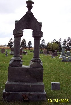
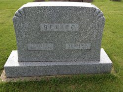
| Burial | : | Hambleton Cemetery, Hambleton, Selby District, England |
| Coordinate | : | 53.7715910, -1.1624600 |
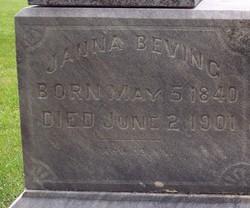
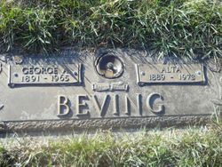
| Description | : | Dick or Dirk was the son of Ubbe Beving and Janna Teyen. He married Tena Heikens on 1 November 1888 in German Township, Grundy, Iowa. They were the parents of Ubbe, George, John, Annie, and Harry Beving. |
frequently asked questions (FAQ):
-
Where is Dick Evers Ubbens Beving's memorial?
Dick Evers Ubbens Beving's memorial is located at: Hambleton Cemetery, Hambleton, Selby District, England.
-
When did Dick Evers Ubbens Beving death?
Dick Evers Ubbens Beving death on 10 Feb 1951 in Iowa, USA
-
Where are the coordinates of the Dick Evers Ubbens Beving's memorial?
Latitude: 53.7715910
Longitude: -1.1624600
Family Members:
Parent
Spouse

Siblings
Children
Flowers:


Nearby Cemetories:
1. Hambleton Cemetery
Hambleton, Selby District, England
Coordinate: 53.7715910, -1.1624600
2. St Mary Churchyard
Hambleton, Selby District, England
Coordinate: 53.7715910, -1.1624600
3. Monk Fryston Cemetery
Monk Fryston, Selby District, England
Coordinate: 53.7604400, -1.2291700
4. St Wilfrid’s Churchyard
Monk Fryston, Selby District, England
Coordinate: 53.7618300, -1.2349700
5. St Mary Churchyard
Birkin, Selby District, England
Coordinate: 53.7325000, -1.1979000
6. St. Wilfrid's Parish Churchyard
Brayton, Selby District, England
Coordinate: 53.7718060, -1.0849010
7. Selby Cemetery
Selby, Selby District, England
Coordinate: 53.7766610, -1.0775960
8. St John The Baptist Churchyard
Chapel Haddlesey, Selby District, England
Coordinate: 53.7279200, -1.1185700
9. St Mary the Virgin Churchyard
South Milford, Selby District, England
Coordinate: 53.7771700, -1.2547300
10. All Saints Churchyard
Wistow, Selby District, England
Coordinate: 53.8134750, -1.1014755
11. St. Edmund's Churchyard
Kellington, Selby District, England
Coordinate: 53.7142600, -1.1710500
12. Selby Abbey
Selby, Selby District, England
Coordinate: 53.7840990, -1.0670270
13. All Saints Churchyard
Sherburn-in-Elmet, Selby District, England
Coordinate: 53.7956000, -1.2605740
14. St Mary the Virgin Churchyard
Church Fenton, Selby District, England
Coordinate: 53.8243100, -1.2203500
15. All Saints Churchyard
Cawood, Selby District, England
Coordinate: 53.8331970, -1.1235660
16. Rythergate Cemetery
Cawood, Selby District, England
Coordinate: 53.8356000, -1.1347700
17. Holy Trinity Churchyard
Barkston Ash, Selby District, England
Coordinate: 53.8189530, -1.2547620
18. United Reformed Churchyard
Knottingley, Metropolitan Borough of Wakefield, England
Coordinate: 53.7104820, -1.2397270
19. All Saints Churchyard
Ryther, Selby District, England
Coordinate: 53.8478600, -1.1576100
20. All Saints Churchyard
Barlby, Selby District, England
Coordinate: 53.7987840, -1.0415840
21. Brotherton United Reformed Church
Brotherton, Selby District, England
Coordinate: 53.7277104, -1.2698131
22. St James Churchyard
Fairburn, Selby District, England
Coordinate: 53.7426700, -1.2841000
23. St. Botolph Churchyard
Knottingley, Metropolitan Borough of Wakefield, England
Coordinate: 53.7108080, -1.2441680
24. Ropewalk Methodist Church Burial Ground
Knottingley, Metropolitan Borough of Wakefield, England
Coordinate: 53.7092850, -1.2408320