
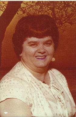
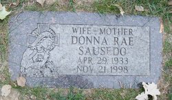

Donna Rae Spracklin Sausedo
| Birth | : | 29 Apr 1933 Persia, Harrison County, Iowa, USA |
| Death | : | 21 Nov 1998 Omaha, Douglas County, Nebraska, USA |
| Burial | : | Cedar Lawn Cemetery, Council Bluffs, Pottawattamie County, USA |
| Coordinate | : | 41.2694016, -95.8182983 |
| Description | : | Donna Rae (Spracklin) Sausedo born to Minnie Inez Lytle 12/13/1891-1/31/1979 and Raymond Otha Spracklin 9/17/1890-1/17/1935. Donna has 7 siblings. 1)Blanche Inez (Newland) Kennedy 4/4/1914-11/13/1993. 2)Anna Isabelle "Annabelle" (Newland) Krough 2/17/1916-1/5/2003. 3)Dorothy Ellen (Newland) Stackhouse 2/1/1918-10/5/2003. 4)Charles Marcus Newland 6/2/1919-8/6/2005. 5)Mabel Clara (Newland) Grate 8/6/1921-2/29/2000. 6)Donald Elsworth Newland 9/13/1923-8/21/2002. 7)Catherine Minnie (Hansen) Harriman 3/14/1930-4/8/1977. Married Joseph Sausedo 8/6/1949. Together they had 5 beautiful daughters Gloria Jean, Donna Marie, Connie Jo, Anita Louise, and Judy Lynn. 9 granddaughters Monica, Diana, Angela, Melissa, Jody, Sarah, Carla, Gloria, and Crystal. 6 grandsons... Read More |
frequently asked questions (FAQ):
-
Where is Donna Rae Spracklin Sausedo's memorial?
Donna Rae Spracklin Sausedo's memorial is located at: Cedar Lawn Cemetery, Council Bluffs, Pottawattamie County, USA.
-
When did Donna Rae Spracklin Sausedo death?
Donna Rae Spracklin Sausedo death on 21 Nov 1998 in Omaha, Douglas County, Nebraska, USA
-
Where are the coordinates of the Donna Rae Spracklin Sausedo's memorial?
Latitude: 41.2694016
Longitude: -95.8182983
Family Members:
Parent

Spouse
Siblings
Children
Flowers:


Nearby Cemetories:
1. Cedar Lawn Cemetery
Council Bluffs, Pottawattamie County, USA
Coordinate: 41.2694016, -95.8182983
2. Oak Hill Cemetery
Council Bluffs, Pottawattamie County, USA
Coordinate: 41.2700900, -95.8226400
3. Saint Joseph Cemetery
Council Bluffs, Pottawattamie County, USA
Coordinate: 41.2722015, -95.8208008
4. Bikhor Cholim Cemetery
Council Bluffs, Pottawattamie County, USA
Coordinate: 41.2703670, -95.8229350
5. Green Valley Cemetery
Council Bluffs, Pottawattamie County, USA
Coordinate: 41.2743988, -95.8225021
6. Walnut Hill Cemetery
Council Bluffs, Pottawattamie County, USA
Coordinate: 41.2719002, -95.8255997
7. Ridgewood Cemetery
Council Bluffs, Pottawattamie County, USA
Coordinate: 41.2694016, -95.8272018
8. Memorial Park Cemetery
Council Bluffs, Pottawattamie County, USA
Coordinate: 41.2644005, -95.8261032
9. Clark Cemetery
Pottawattamie County, USA
Coordinate: 41.2551610, -95.8223390
10. Fairview Cemetery
Council Bluffs, Pottawattamie County, USA
Coordinate: 41.2703018, -95.8480988
11. Garner Cemetery
Council Bluffs, Pottawattamie County, USA
Coordinate: 41.2956161, -95.8001709
12. Stoker-Graybill Cemetery
Council Bluffs, Pottawattamie County, USA
Coordinate: 41.2532620, -95.7751770
13. Maple Grove Cemetery
Council Bluffs, Pottawattamie County, USA
Coordinate: 41.2265560, -95.8187100
14. Evans Cemetery
Crescent, Pottawattamie County, USA
Coordinate: 41.3255997, -95.8368988
15. Lewis Township Cemetery
Council Bluffs, Pottawattamie County, USA
Coordinate: 41.2117004, -95.7938995
16. Gregg Cemetery
Weston, Pottawattamie County, USA
Coordinate: 41.3330000, -95.7931000
17. Council Point Cemetery
Council Bluffs, Pottawattamie County, USA
Coordinate: 41.2110830, -95.8788610
18. Hazel Dell Cemetery
Council Bluffs, Pottawattamie County, USA
Coordinate: 41.3489723, -95.7939911
19. Trinity Cathedral Columbarium
Omaha, Douglas County, USA
Coordinate: 41.2603900, -95.9393660
20. Saint Columbanus Cemetery
Weston, Pottawattamie County, USA
Coordinate: 41.3429440, -95.7435260
21. Crescent Cemetery
Crescent, Pottawattamie County, USA
Coordinate: 41.3664894, -95.8566208
22. Prospect Hill Cemetery
Omaha, Douglas County, USA
Coordinate: 41.2780991, -95.9593964
23. Saint Pauls Evangelical Country Church Cemetery
Dumfries, Pottawattamie County, USA
Coordinate: 41.1748352, -95.7492371
24. First Central Congregational Columbarium
Omaha, Douglas County, USA
Coordinate: 41.2563456, -95.9658365