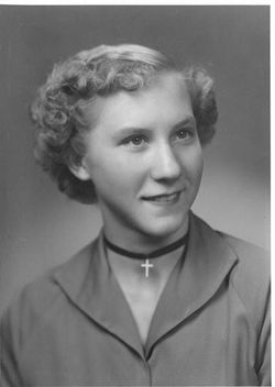
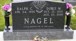
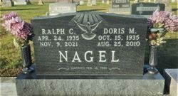
Doris M Kruse Nagel
| Birth | : | 15 Oct 1935 Henry County, Ohio, USA |
| Death | : | 25 Aug 2010 Defiance, Defiance County, Ohio, USA |
| Burial | : | St Mary's Churchyard, Fawsley, Daventry District, England |
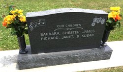
| Description | : | Doris Nagel, 74, Defiance, Ohio, died Wednesday, August 25, 2010, at CHP Defiance Area In-Patient Hospice Center. She was born October 15, 1935, in Henry County, the daughter of Fred and Pauline (Wesche) Kruse. On February 19, 1955, she married Ralph Nagel, Defiance, who survives. She was a cook at Tinora Schools, retiring after 25 years. She was also a member and choir director of St. Mark's Lutheran Church, rural Defiance, and president of WELCA. Also surviving are three sons, Chester (Kathi) Nagel of Defiance, James Nagel of Defiance and Rich (Mary Alice) Nagel of Defiance; three daughters, Barb Bishop of Fort... Read More |
frequently asked questions (FAQ):
-
Where is Doris M Kruse Nagel's memorial?
Doris M Kruse Nagel's memorial is located at: St Mary's Churchyard, Fawsley, Daventry District, England.
-
When did Doris M Kruse Nagel death?
Doris M Kruse Nagel death on 25 Aug 2010 in Defiance, Defiance County, Ohio, USA
Family Members:
Spouse
Siblings
Flowers:
Nearby Cemetories:
1. All Saints Churchyard
Braunston, Daventry District, England
Coordinate: 52.3404255, -0.8248900
2. Holy Trinity Churchyard
Charwelton, Daventry District, England
Coordinate: 52.3385720, -0.8314720
3. All Saints Churchyard
Cottesbrooke, Daventry District, England
Coordinate: 52.3409590, -1.0764700
4. East Farndon Burial Ground
East Farndon, Daventry District, England
Coordinate: 52.2240200, -1.1820100
5. Saint John the Baptist Churchyard
East Farndon, Daventry District, England
Coordinate: 52.1502747, -1.1568058
6. St Mary the Virgin with St John Churchyard
Great Brington, Daventry District, England
Coordinate: 52.3871456, -1.1290185
7. Saint Michael's Churchyard
Haselbech, Daventry District, England
Coordinate: 52.3469872, -1.1339944
8. All Saints Churchyard
Lilbourne, Daventry District, England
Coordinate: 52.3476230, -1.1378110
9. Greenhaven Woodland Burial Ground
Lilbourne, Daventry District, England
Coordinate: 52.2123168, -1.1310740
10. Lilbourne Burial Ground
Lilbourne, Daventry District, England
Coordinate: 52.3480310, -1.0089780
11. All Saints Churchyard
Norton, Daventry District, England
Coordinate: 52.3021000, -0.9868100
12. St. Helen's Churchyard
Sibbertoft, Daventry District, England
Coordinate: 52.3022756, -1.0804149
13. St. Peter's Churchyard
Walgrave, Daventry District, England
Coordinate: 52.3404255, -0.8248900
14. Walgrave Cemetery
Walgrave, Daventry District, England
Coordinate: 52.3385720, -0.8314720
15. All Saints Churchyard
West Haddon, Daventry District, England
Coordinate: 52.3409590, -1.0764700
16. St. Mary the Virgin
Badby, Daventry District, England
Coordinate: 52.2240200, -1.1820100
17. St. Mary’s Churchyard
Canons Ashby, Daventry District, England
Coordinate: 52.1502747, -1.1568058
18. St. Andrew's Churchyard
Clay Coton, Daventry District, England
Coordinate: 52.3871456, -1.1290185
19. Crick United Reformed Churchyard
Crick, Daventry District, England
Coordinate: 52.3469872, -1.1339944
20. St. Margaret Churchyard
Crick, Daventry District, England
Coordinate: 52.3476230, -1.1378110
21. Everdon Parish CHurchyard
Everdon, Daventry District, England
Coordinate: 52.2123168, -1.1310740
22. St Etheldreda Churchyard
Guilsborough, Daventry District, England
Coordinate: 52.3480310, -1.0089780
23. All Saints Churchyard
Holdenby, Daventry District, England
Coordinate: 52.3021000, -0.9868100
24. Long Buckby & Brington Baptist Church
Long Buckby, Daventry District, England
Coordinate: 52.3022756, -1.0804149

