
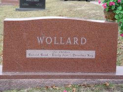
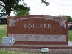
Dorothea Marie Cramer Wollard
| Birth | : | 27 Apr 1924 Ray County, Missouri, USA |
| Death | : | 18 Jan 2015 Richmond, Ray County, Missouri, USA |
| Burial | : | New Hope United Methodist Church Cemetery, Millville, Ray County, USA |
| Coordinate | : | 39.4236259, -93.8416061 |
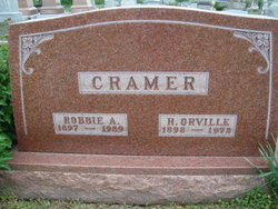
| Description | : | Dorothea Marie Wollard, 90, of Richmond, MO died Sunday, January 18, 2015 at her home. Dorothea was born on April 27, 1924 in Ray County, MO to Orville and Robbie (Teegarden) Cramer. She married Forrest “Babe” Wollard of Ray County on February 13, 1942. He survives of the home. Additional survivors include one son and daughter-in-law, Dr. Ronald R. and Marilyn Wollard of Mission Hills, KS; two daughters, Kay Mertensmeyer of Richmond and Emily J. Vandeginste of North Kansas City, MO; 9 grandchildren and their spouses, Chad and Susie Wollard, Zachary Wollard and his wife, Erica... Read More |
frequently asked questions (FAQ):
-
Where is Dorothea Marie Cramer Wollard's memorial?
Dorothea Marie Cramer Wollard's memorial is located at: New Hope United Methodist Church Cemetery, Millville, Ray County, USA.
-
When did Dorothea Marie Cramer Wollard death?
Dorothea Marie Cramer Wollard death on 18 Jan 2015 in Richmond, Ray County, Missouri, USA
-
Where are the coordinates of the Dorothea Marie Cramer Wollard's memorial?
Latitude: 39.4236259
Longitude: -93.8416061
Family Members:
Parent

Spouse

Siblings
Flowers:


Nearby Cemetories:
1. New Hope United Methodist Church Cemetery
Millville, Ray County, USA
Coordinate: 39.4236259, -93.8416061
2. Old New Hope Cemetery
Millville, Ray County, USA
Coordinate: 39.4327200, -93.8435900
3. McCuistion Cemetery
Richmond, Ray County, USA
Coordinate: 39.4387300, -93.8550900
4. Silas Keith Cemetery
Regal, Ray County, USA
Coordinate: 39.4387800, -93.8262100
5. Mansur Cemetery
Grape Grove Township, Ray County, USA
Coordinate: 39.4230003, -93.8804016
6. Carleton Cemetery
Ray County, USA
Coordinate: 39.4014200, -93.8712700
7. Smith Cemetery
Ray County, USA
Coordinate: 39.4028015, -93.8799973
8. Berry Cemetery
Hardin, Ray County, USA
Coordinate: 39.3913800, -93.8710800
9. Nuckles Cemetery
Richmond, Ray County, USA
Coordinate: 39.4143700, -93.8950300
10. Bethany Church Cemetery
Stet, Ray County, USA
Coordinate: 39.4230995, -93.7838974
11. Woolard Cemetery
Hardin, Ray County, USA
Coordinate: 39.3769300, -93.8351500
12. Felix Wild Cemetery
Ray County, USA
Coordinate: 39.4398200, -93.9110700
13. Antioch Cemetery
Millville, Ray County, USA
Coordinate: 39.4563040, -93.9077420
14. Van Wall Cemetery
Grape Grove Township, Ray County, USA
Coordinate: 39.4513800, -93.9116700
15. Moyer Cemetery
Ray County, USA
Coordinate: 39.4244100, -93.9224100
16. Graff Cemetery
Grape Grove Township, Ray County, USA
Coordinate: 39.4909286, -93.8144836
17. Wakenda Cemetery
Hardin, Ray County, USA
Coordinate: 39.3519300, -93.8456900
18. Meinking-Wilson Cemetery
Ray County, USA
Coordinate: 39.3576200, -93.7995600
19. Millville Community Cemetery
Millville, Ray County, USA
Coordinate: 39.4041100, -93.9351600
20. Little Union Cemetery
Stet, Ray County, USA
Coordinate: 39.4972343, -93.8660507
21. Bethel Mennonite Church Cemetery
Richmond, Ray County, USA
Coordinate: 39.3936900, -93.9330400
22. Basham Cemetery
Ray County, USA
Coordinate: 39.4963400, -93.8810700
23. Mount Olivet Cemetery
Stet, Carroll County, USA
Coordinate: 39.4366000, -93.7403000
24. Elder Cemetery
Grape Grove Township, Ray County, USA
Coordinate: 39.5015259, -93.8108826