


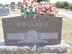
Forrest Wade “Babe” Wollard
| Birth | : | 25 Jan 1921 |
| Death | : | 27 Sep 2018 |
| Burial | : | New Hope United Methodist Church Cemetery, Millville, Ray County, USA |
| Coordinate | : | 39.4236259, -93.8416061 |
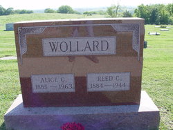
| Description | : | Forrest Wade “Babe” Wollard, 97, formerly of Richmond, Missouri, died on Thursday, September 27, 2018 at Wexford Place Assisted Care in Parkville, Missouri. Forrest was born January 25, 1921, to Alice Pugh Wollard and Reed C. Wollard in rural Hardin, Missouri. He attended Richmond, Missouri, schools until he entered Central High School at Rockingham, Missouri. Forrest was on the basketball team at Central and graduated in 1939. He met and married Dorothea Marie Cramer (1926-2015) on February 13, 1942, during World War II. Forrest spent 39 months in the 2nd Army Air Corps. After... Read More |
frequently asked questions (FAQ):
-
Where is Forrest Wade “Babe” Wollard's memorial?
Forrest Wade “Babe” Wollard's memorial is located at: New Hope United Methodist Church Cemetery, Millville, Ray County, USA.
-
When did Forrest Wade “Babe” Wollard death?
Forrest Wade “Babe” Wollard death on 27 Sep 2018 in
-
Where are the coordinates of the Forrest Wade “Babe” Wollard's memorial?
Latitude: 39.4236259
Longitude: -93.8416061
Family Members:
Parent
Spouse
Siblings
Flowers:


Nearby Cemetories:
1. New Hope United Methodist Church Cemetery
Millville, Ray County, USA
Coordinate: 39.4236259, -93.8416061
2. Old New Hope Cemetery
Millville, Ray County, USA
Coordinate: 39.4327200, -93.8435900
3. McCuistion Cemetery
Richmond, Ray County, USA
Coordinate: 39.4387300, -93.8550900
4. Silas Keith Cemetery
Regal, Ray County, USA
Coordinate: 39.4387800, -93.8262100
5. Mansur Cemetery
Grape Grove Township, Ray County, USA
Coordinate: 39.4230003, -93.8804016
6. Carleton Cemetery
Ray County, USA
Coordinate: 39.4014200, -93.8712700
7. Smith Cemetery
Ray County, USA
Coordinate: 39.4028015, -93.8799973
8. Berry Cemetery
Hardin, Ray County, USA
Coordinate: 39.3913800, -93.8710800
9. Nuckles Cemetery
Richmond, Ray County, USA
Coordinate: 39.4143700, -93.8950300
10. Bethany Church Cemetery
Stet, Ray County, USA
Coordinate: 39.4230995, -93.7838974
11. Woolard Cemetery
Hardin, Ray County, USA
Coordinate: 39.3769300, -93.8351500
12. Felix Wild Cemetery
Ray County, USA
Coordinate: 39.4398200, -93.9110700
13. Antioch Cemetery
Millville, Ray County, USA
Coordinate: 39.4563040, -93.9077420
14. Van Wall Cemetery
Grape Grove Township, Ray County, USA
Coordinate: 39.4513800, -93.9116700
15. Moyer Cemetery
Ray County, USA
Coordinate: 39.4244100, -93.9224100
16. Graff Cemetery
Grape Grove Township, Ray County, USA
Coordinate: 39.4909286, -93.8144836
17. Wakenda Cemetery
Hardin, Ray County, USA
Coordinate: 39.3519300, -93.8456900
18. Meinking-Wilson Cemetery
Ray County, USA
Coordinate: 39.3576200, -93.7995600
19. Millville Community Cemetery
Millville, Ray County, USA
Coordinate: 39.4041100, -93.9351600
20. Little Union Cemetery
Stet, Ray County, USA
Coordinate: 39.4972343, -93.8660507
21. Bethel Mennonite Church Cemetery
Richmond, Ray County, USA
Coordinate: 39.3936900, -93.9330400
22. Basham Cemetery
Ray County, USA
Coordinate: 39.4963400, -93.8810700
23. Mount Olivet Cemetery
Stet, Carroll County, USA
Coordinate: 39.4366000, -93.7403000
24. Elder Cemetery
Grape Grove Township, Ray County, USA
Coordinate: 39.5015259, -93.8108826