| Birth | : | 25 Mar 1885 Mills County, Iowa, USA |
| Death | : | 17 Dec 1971 Council Bluffs, Pottawattamie County, Iowa, USA |
| Burial | : | East Gilead Cemetery, East Gilead, Branch County, USA |
| Coordinate | : | 41.7858330, -85.0825000 |
| Plot | : | Section 14 Lot 772 |
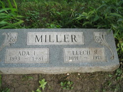
| Description | : | Earl McLain Shook Funeral services were held Monday morning at the Nelson Chapel in Red Oak for Earl McLain Shook, 86. Mr. Shook died Friday at the Murphy Memorial Hospital in Red Oak. Rev. Carl Grouse officiated at the services with burial in Malvern Cemetery. Among relatives from a distance attending were: the Max Shook family of Loveland, Colo.; Mr. and Mrs. Donald Rogers, Kansas City; Mr. and Mrs. Lee Naylor and Mrs. Mary Naylor, Des Moines; Mr. and Mrs. Cal Shapcott and Mr. and Mrs. Tom Shapcott, Villisca; the Laurence White family, Tabor; Mrs. Leech Miller, Ellbridge Shook... Read More |
frequently asked questions (FAQ):
-
Where is Earl McLain Shook's memorial?
Earl McLain Shook's memorial is located at: East Gilead Cemetery, East Gilead, Branch County, USA.
-
When did Earl McLain Shook death?
Earl McLain Shook death on 17 Dec 1971 in Council Bluffs, Pottawattamie County, Iowa, USA
-
Where are the coordinates of the Earl McLain Shook's memorial?
Latitude: 41.7858330
Longitude: -85.0825000
Family Members:
Parent
Spouse
Siblings
Children
Flowers:
Nearby Cemetories:
1. East Gilead Cemetery
East Gilead, Branch County, USA
Coordinate: 41.7858330, -85.0825000
2. West Jamestown Cemetery
Jamestown, Steuben County, USA
Coordinate: 41.7447014, -85.0382996
3. South Gilead Cemetery
Bronson, Branch County, USA
Coordinate: 41.7733330, -85.1566670
4. North Gilead Cemetery
Gilead Township, Branch County, USA
Coordinate: 41.8039017, -85.1557999
5. Knauss Cemetery
Kinderhook, Branch County, USA
Coordinate: 41.7872009, -85.0002975
6. Waterhouse Cemetery
Kinderhook, Branch County, USA
Coordinate: 41.7961006, -84.9985962
7. Carleton Cemetery
Orland, Steuben County, USA
Coordinate: 41.7369890, -85.1403120
8. Card Cemetery
Bethel Township, Branch County, USA
Coordinate: 41.8544006, -85.0693970
9. Sorter Cemetery
Ovid Township, Branch County, USA
Coordinate: 41.8272220, -85.0052770
10. Greenlawn Cemetery
Orland, Steuben County, USA
Coordinate: 41.7338982, -85.1594009
11. Mill Grove Cemetery
Orland, Steuben County, USA
Coordinate: 41.7327995, -85.1718979
12. Curtis Cemetery
Bronson, Branch County, USA
Coordinate: 41.8039017, -85.1956024
13. Ovid Cemetery
Ovid Township, Branch County, USA
Coordinate: 41.8688580, -85.0484920
14. Peace Lutheran Church
Fremont, Steuben County, USA
Coordinate: 41.7298670, -84.9841800
15. Mundy Cemetery
Kinderhook, Branch County, USA
Coordinate: 41.7747002, -84.9586029
16. Lake Gage Cemetery
Angola, Steuben County, USA
Coordinate: 41.6927986, -85.0927963
17. Snow Prairie Cemetery
Bethel, Branch County, USA
Coordinate: 41.8699989, -85.1408005
18. Pleasant Hill Cemetery
Noble Township, Branch County, USA
Coordinate: 41.7961110, -85.2111110
19. Robinson Family Cemetery
Orland, Steuben County, USA
Coordinate: 41.6927030, -85.1412750
20. Bower Cemetery
Fremont, Steuben County, USA
Coordinate: 41.7458200, -84.9537370
21. Presbyterian Chapel of the Lakes Memorial Gardens
Angola, Steuben County, USA
Coordinate: 41.6846930, -85.0469690
22. Saint Marys Cemetery
Bronson, Branch County, USA
Coordinate: 41.8582993, -85.1939011
23. Lockwood Cemetery
Coldwater, Branch County, USA
Coordinate: 41.8837250, -85.0145170
24. Bronson Cemetery
Bronson, Branch County, USA
Coordinate: 41.8699340, -85.1858320

