

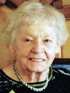
Edith Marilyn Evans Petersen
| Birth | : | 25 Dec 1919 Glenwood, Mills County, Iowa, USA |
| Death | : | 26 Oct 2020 |
| Burial | : | Cedar Lawn Cemetery, Council Bluffs, Pottawattamie County, USA |
| Coordinate | : | 41.2694016, -95.8182983 |
| Description | : | Edith Marilyn Petersen December 25, 1919 - October 26, 2020 Edith Marilyn Petersen, age 100, passed away October 26, 2020, at her residence. Edith was born December 23, 1919, in rural Glenwood, IA., to the late Lew Boyd and Hazel W. (Hunt) Evans. She was a graduate of University of Iowa. Edith proudly served in the US Army during WWII, as a nurse in Sydney Australia, New Guinea and the Philippines. Upon her return from duty, Edith married Henry R. Petersen on April 8, 1951, at St .Paul's Lutheran Church in Council Bluffs, and to this union 5 children... Read More |
frequently asked questions (FAQ):
-
Where is Edith Marilyn Evans Petersen's memorial?
Edith Marilyn Evans Petersen's memorial is located at: Cedar Lawn Cemetery, Council Bluffs, Pottawattamie County, USA.
-
When did Edith Marilyn Evans Petersen death?
Edith Marilyn Evans Petersen death on 26 Oct 2020 in
-
Where are the coordinates of the Edith Marilyn Evans Petersen's memorial?
Latitude: 41.2694016
Longitude: -95.8182983
Family Members:
Spouse

Flowers:


Nearby Cemetories:
1. Cedar Lawn Cemetery
Council Bluffs, Pottawattamie County, USA
Coordinate: 41.2694016, -95.8182983
2. Oak Hill Cemetery
Council Bluffs, Pottawattamie County, USA
Coordinate: 41.2700900, -95.8226400
3. Saint Joseph Cemetery
Council Bluffs, Pottawattamie County, USA
Coordinate: 41.2722015, -95.8208008
4. Bikhor Cholim Cemetery
Council Bluffs, Pottawattamie County, USA
Coordinate: 41.2703670, -95.8229350
5. Green Valley Cemetery
Council Bluffs, Pottawattamie County, USA
Coordinate: 41.2743988, -95.8225021
6. Walnut Hill Cemetery
Council Bluffs, Pottawattamie County, USA
Coordinate: 41.2719002, -95.8255997
7. Ridgewood Cemetery
Council Bluffs, Pottawattamie County, USA
Coordinate: 41.2694016, -95.8272018
8. Memorial Park Cemetery
Council Bluffs, Pottawattamie County, USA
Coordinate: 41.2644005, -95.8261032
9. Clark Cemetery
Pottawattamie County, USA
Coordinate: 41.2551610, -95.8223390
10. Fairview Cemetery
Council Bluffs, Pottawattamie County, USA
Coordinate: 41.2703018, -95.8480988
11. Garner Cemetery
Council Bluffs, Pottawattamie County, USA
Coordinate: 41.2956161, -95.8001709
12. Stoker-Graybill Cemetery
Council Bluffs, Pottawattamie County, USA
Coordinate: 41.2532620, -95.7751770
13. Maple Grove Cemetery
Council Bluffs, Pottawattamie County, USA
Coordinate: 41.2265560, -95.8187100
14. Evans Cemetery
Crescent, Pottawattamie County, USA
Coordinate: 41.3255997, -95.8368988
15. Lewis Township Cemetery
Council Bluffs, Pottawattamie County, USA
Coordinate: 41.2117004, -95.7938995
16. Gregg Cemetery
Weston, Pottawattamie County, USA
Coordinate: 41.3330000, -95.7931000
17. Council Point Cemetery
Council Bluffs, Pottawattamie County, USA
Coordinate: 41.2110830, -95.8788610
18. Hazel Dell Cemetery
Council Bluffs, Pottawattamie County, USA
Coordinate: 41.3489723, -95.7939911
19. Trinity Cathedral Columbarium
Omaha, Douglas County, USA
Coordinate: 41.2603900, -95.9393660
20. Saint Columbanus Cemetery
Weston, Pottawattamie County, USA
Coordinate: 41.3429440, -95.7435260
21. Crescent Cemetery
Crescent, Pottawattamie County, USA
Coordinate: 41.3664894, -95.8566208
22. Prospect Hill Cemetery
Omaha, Douglas County, USA
Coordinate: 41.2780991, -95.9593964
23. Saint Pauls Evangelical Country Church Cemetery
Dumfries, Pottawattamie County, USA
Coordinate: 41.1748352, -95.7492371
24. First Central Congregational Columbarium
Omaha, Douglas County, USA
Coordinate: 41.2563456, -95.9658365