


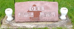
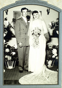
Edmund Cameron “Ed” Orr
| Birth | : | 28 Nov 1880 Delaware County, Iowa, USA |
| Death | : | 2 Nov 1969 Manchester, Delaware County, Iowa, USA |
| Burial | : | Wollaton Cemetery, Wollaton, Nottingham Unitary Authority, England |
| Coordinate | : | 52.9503000, -1.2260800 |
| Description | : | Ref: Edmund C. Orr, 88, resident of Coggon for the past 18 years passed away at Memorial hospital in Manchester early Sunday morning. Funeral services will be held at 1:30 p.m. Wednesday in the First Christian church at Coggon with the Rev. Hugh Ghormley and the Rev. Gary Keast officiating. Burial will be made in the Golden cemetery near Ryan. The Murdoch funeral home is in charge of arrangements where friends may call. He was born Nov. 28, 1880, in Delaware county, a son of Joseph and Matilda (Corell) Orr. On Oct. 25, 1911, he was married to Edith... Read More |
frequently asked questions (FAQ):
-
Where is Edmund Cameron “Ed” Orr's memorial?
Edmund Cameron “Ed” Orr's memorial is located at: Wollaton Cemetery, Wollaton, Nottingham Unitary Authority, England.
-
When did Edmund Cameron “Ed” Orr death?
Edmund Cameron “Ed” Orr death on 2 Nov 1969 in Manchester, Delaware County, Iowa, USA
-
Where are the coordinates of the Edmund Cameron “Ed” Orr's memorial?
Latitude: 52.9503000
Longitude: -1.2260800
Family Members:
Parent

Spouse
Siblings
Children


Flowers:


Nearby Cemetories:
1. St. Leonard's Churchyard
Wollaton, Nottingham Unitary Authority, England
Coordinate: 52.9529790, -1.2200830
2. Beeston Cemetery
Beeston, Broxtowe Borough, England
Coordinate: 52.9354540, -1.2275310
3. Bramcote Crematorium
Beeston, Broxtowe Borough, England
Coordinate: 52.9456300, -1.2555100
4. St. Michael and All Angels Churchyard
Bramcote, Broxtowe Borough, England
Coordinate: 52.9352531, -1.2463690
5. St. John the Baptist Churchyard
Beeston, Broxtowe Borough, England
Coordinate: 52.9255562, -1.2167680
6. All Saints Church
Strelley, Broxtowe Borough, England
Coordinate: 52.9737900, -1.2470340
7. Beeston Baptist Chapel
Beeston, Broxtowe Borough, England
Coordinate: 52.9246600, -1.2122000
8. St. Peter Churchyard Old Radford
Nottingham, Nottingham Unitary Authority, England
Coordinate: 52.9601830, -1.1789620
9. Holy Trinity Churchyard
Lenton, Nottingham Unitary Authority, England
Coordinate: 52.9485630, -1.1753148
10. Stapleford Cemetery
Stapleford, Broxtowe Borough, England
Coordinate: 52.9299770, -1.2699190
11. St. Helen's Churchyard
Trowell, Broxtowe Borough, England
Coordinate: 52.9528120, -1.2815590
12. St. Helen's Churchyard
Stapleford, Broxtowe Borough, England
Coordinate: 52.9316670, -1.2744440
13. Chilwell Cemetery
Nottingham, Nottingham Unitary Authority, England
Coordinate: 52.9164070, -1.2430800
14. Hardy Street Jewish Cemetery
Nottingham, Nottingham Unitary Authority, England
Coordinate: 52.9619500, -1.1665900
15. General Cemetery
Nottingham, Nottingham Unitary Authority, England
Coordinate: 52.9561430, -1.1615420
16. Nottingham General Cemetery
Nottingham, Nottingham Unitary Authority, England
Coordinate: 52.9575370, -1.1594236
17. St. Leodegarius Churchyard
Old Basford, Nottingham Unitary Authority, England
Coordinate: 52.9794240, -1.1778650
18. Cathedral Church of St. Barnabas
Nottingham, Nottingham Unitary Authority, England
Coordinate: 52.9546750, -1.1570460
19. St. Wilfrid Churchyard
Wilford, Nottingham Unitary Authority, England
Coordinate: 52.9346290, -1.1587770
20. Wilford Village Cemetery
Wilford, Nottingham Unitary Authority, England
Coordinate: 52.9338540, -1.1591170
21. Basford Cemetery
Old Basford, Nottingham Unitary Authority, England
Coordinate: 52.9799700, -1.1725900
22. Nottingham Church Cemetery
Nottingham, Nottingham Unitary Authority, England
Coordinate: 52.9649830, -1.1558070
23. St Nicholas Churchyard
Nottingham, Nottingham Unitary Authority, England
Coordinate: 52.9504780, -1.1509220
24. St Mary's Churchyard
Clifton, Nottingham Unitary Authority, England
Coordinate: 52.9083870, -1.1965435