
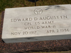
Edward Dennis Augustyn
| Birth | : | 20 Nov 1917 Sherman County, Nebraska, USA |
| Death | : | 2 Apr 1986 Loup City, Sherman County, Nebraska, USA |
| Burial | : | Breachwood Green Baptist Church, Kings Walden, North Hertfordshire District, England |
| Coordinate | : | 51.8843200, -0.3293700 |
| Description | : | Son of John J. & Mary Kathryn (Gzehoviak) Augustyn. Was not married. Occupation: Maganger of Spelts Lumber Co. in Elba, NE. for several years. Later he was a farmer near Loup City. WW II Veteran - US Army - 1942/1945 |
frequently asked questions (FAQ):
-
Where is Edward Dennis Augustyn's memorial?
Edward Dennis Augustyn's memorial is located at: Breachwood Green Baptist Church, Kings Walden, North Hertfordshire District, England.
-
When did Edward Dennis Augustyn death?
Edward Dennis Augustyn death on 2 Apr 1986 in Loup City, Sherman County, Nebraska, USA
-
Where are the coordinates of the Edward Dennis Augustyn's memorial?
Latitude: 51.8843200
Longitude: -0.3293700
Family Members:
Parent
Siblings

Flowers:


Nearby Cemetories:
1. Breachwood Green Baptist Church
Kings Walden, North Hertfordshire District, England
Coordinate: 51.8843200, -0.3293700
2. St Martins
Preston, North Hertfordshire District, England
Coordinate: 51.9091932, -0.2876494
3. All Saints Churchyard
St Pauls Walden, North Hertfordshire District, England
Coordinate: 51.8865400, -0.2689200
4. Ss Peter and Paul Churchyard
Kimpton, North Hertfordshire District, England
Coordinate: 51.8527990, -0.2918240
5. Luton Vauxhall Motors War Memorial
Luton, Luton Borough, England
Coordinate: 51.8745100, -0.3967500
6. St Mary Magdalene Churchyard
Offley, North Hertfordshire District, England
Coordinate: 51.9277300, -0.3357400
7. Vale Cemetery and Crematorium
Luton, Luton Borough, England
Coordinate: 51.9070900, -0.3924930
8. Quaker Burial Ground
Luton, Luton Borough, England
Coordinate: 51.8791910, -0.4023320
9. Church Burial Ground
Luton, Luton Borough, England
Coordinate: 51.8794640, -0.4027310
10. Holy Trinity Churchyard
East Hyde, Central Bedfordshire Unitary Authority, England
Coordinate: 51.8433710, -0.3640760
11. Minsden Chapel
Hitchin, North Hertfordshire District, England
Coordinate: 51.9069200, -0.2595700
12. St. Mary's Churchyard
Luton, Luton Borough, England
Coordinate: 51.8788681, -0.4100020
13. Friend's Burial Ground
Luton, Luton Borough, England
Coordinate: 51.8738060, -0.4170870
14. National Children's Home Cemetery
Harpenden, St Albans District, England
Coordinate: 51.8305000, -0.3563000
15. St Lawrence Churchyard
Ayot St Lawrence, Welwyn Hatfield District, England
Coordinate: 51.8379490, -0.2717340
16. Luton General Cemetery
Luton, Luton Borough, England
Coordinate: 51.8773780, -0.4242060
17. Westfield Road Cemetery
Harpenden, St Albans District, England
Coordinate: 51.8270720, -0.3540300
18. Ayot St Lawrence Old Churchyard
Ayot St Lawrence, Welwyn Hatfield District, England
Coordinate: 51.8377038, -0.2678795
19. St Ippolyts Church
St Ippolyts, North Hertfordshire District, England
Coordinate: 51.9298460, -0.2591680
20. St Andrew Woodside Churchyard
Slip End, Central Bedfordshire Unitary Authority, England
Coordinate: 51.8577160, -0.4306600
21. Hitchin Cemetery
Hitchin, North Hertfordshire District, England
Coordinate: 51.9429090, -0.2732690
22. Holy Trinity Churchyard
Biscot, Luton Borough, England
Coordinate: 51.9028700, -0.4375560
23. St Nicholas Churchyard
Harpenden, St Albans District, England
Coordinate: 51.8169470, -0.3583300
24. St. Mary's Churchyard
Knebworth, North Hertfordshire District, England
Coordinate: 51.8723580, -0.2160890