
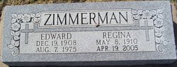
Edward Joseph Zimmerman
| Birth | : | 19 Dec 1908 Hays, Ellis County, Kansas, USA |
| Death | : | 7 Aug 1975 Hays, Ellis County, Kansas, USA |
| Burial | : | Saint Mary Churchyard, Stoke by Nayland, Babergh District, England |
| Coordinate | : | 51.9895000, 0.8925210 |
frequently asked questions (FAQ):
-
Where is Edward Joseph Zimmerman's memorial?
Edward Joseph Zimmerman's memorial is located at: Saint Mary Churchyard, Stoke by Nayland, Babergh District, England.
-
When did Edward Joseph Zimmerman death?
Edward Joseph Zimmerman death on 7 Aug 1975 in Hays, Ellis County, Kansas, USA
-
Where are the coordinates of the Edward Joseph Zimmerman's memorial?
Latitude: 51.9895000
Longitude: 0.8925210
Family Members:
Parent
Spouse
Siblings

Flowers:


Nearby Cemetories:
1. Saint Mary Churchyard
Stoke by Nayland, Babergh District, England
Coordinate: 51.9895000, 0.8925210
2. St Mary Churchyard
Polstead, Babergh District, England
Coordinate: 52.0054860, 0.8964940
3. St. James' Churchyard
Nayland, Babergh District, England
Coordinate: 51.9715440, 0.8748140
4. Nayland Cemetery
Nayland, Babergh District, England
Coordinate: 51.9735000, 0.8677410
5. Our Lady Immaculate Withermarsh Green
Stoke by Nayland, Babergh District, England
Coordinate: 51.9950800, 0.9326260
6. Saint Peters Churchyard
Boxted, Colchester Borough, England
Coordinate: 51.9617380, 0.9072480
7. All Saints Churchyard
Great Horkesley, Colchester Borough, England
Coordinate: 51.9550190, 0.8672580
8. St. Mary the Virgin Churchyard
Wissington, Babergh District, England
Coordinate: 51.9634930, 0.8436940
9. Boxford Cemetery
Boxford, Babergh District, England
Coordinate: 52.0268400, 0.8601300
10. St Mary's Churchyard
Boxford, Babergh District, England
Coordinate: 52.0280870, 0.8594160
11. St Mary's Church Burial Ground
Higham, Forest Heath District, England
Coordinate: 51.9782680, 0.9626690
12. St. Peter and St. Paul's Churchyard
Little Horkesley, Colchester Borough, England
Coordinate: 51.9516000, 0.8517000
13. St Mary the Virgin Churchyard
Langham, Colchester Borough, England
Coordinate: 51.9644450, 0.9596300
14. St Edmund King and Martyr Churchyard
Assington, Babergh District, England
Coordinate: 52.0138120, 0.8194260
15. World War I Memorial
Assington, Babergh District, England
Coordinate: 52.0138200, 0.8193504
16. St. Andrew's Churchyard
Layham, Babergh District, England
Coordinate: 52.0240520, 0.9580820
17. St. Bartholomew's Churchyard
Groton, Babergh District, England
Coordinate: 52.0388810, 0.8558090
18. St. Mary Churchyard
Raydon, Babergh District, England
Coordinate: 52.0081090, 0.9847290
19. St Mary's Churchyard
Stratford St Mary, Babergh District, England
Coordinate: 51.9718250, 0.9862600
20. St Andrew Churchyard
Wormingford, Colchester Borough, England
Coordinate: 51.9551000, 0.8115000
21. Chapel of St. Stephen
Bures St Mary, Babergh District, England
Coordinate: 51.9753000, 0.7907000
22. Hadleigh United Reformed Churchyard
Hadleigh, Babergh District, England
Coordinate: 52.0426790, 0.9533380
23. St. Mary's Churchyard
Holton St Mary, Babergh District, England
Coordinate: 51.9911800, 0.9982800
24. St. Mary's Churchyard
Hadleigh, Babergh District, England
Coordinate: 52.0436290, 0.9526880