
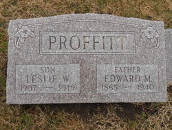
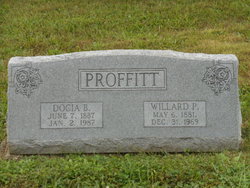
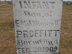
Edward M. Proffitt
| Birth | : | 26 May 1865 USA |
| Death | : | 30 Jun 1940 Richmond, Ray County, Missouri, USA |
| Burial | : | Saffron Hill Cemetery, Leicester, Leicester Unitary Authority, England |
| Coordinate | : | 52.5934120, -1.1310010 |
| Plot | : | Bottom/Sect.5 |
frequently asked questions (FAQ):
-
Where is Edward M. Proffitt's memorial?
Edward M. Proffitt's memorial is located at: Saffron Hill Cemetery, Leicester, Leicester Unitary Authority, England.
-
When did Edward M. Proffitt death?
Edward M. Proffitt death on 30 Jun 1940 in Richmond, Ray County, Missouri, USA
-
Where are the coordinates of the Edward M. Proffitt's memorial?
Latitude: 52.5934120
Longitude: -1.1310010
Family Members:
Parent
Spouse
Siblings
Children


Nearby Cemetories:
1. Saffron Hill Cemetery
Leicester, Leicester Unitary Authority, England
Coordinate: 52.5934120, -1.1310010
2. Saint Mary Magdalene Churchyard
Knighton, Leicester Unitary Authority, England
Coordinate: 52.6054170, -1.1163730
3. All Saints Churchyard
Wigston, Oadby and Wigston Borough, England
Coordinate: 52.5823880, -1.1096900
4. Wigston United Reformed Church
Wigston, Oadby and Wigston Borough, England
Coordinate: 52.5840900, -1.1071200
5. St Wistan's Churchyard
Wigston, Oadby and Wigston Borough, England
Coordinate: 52.5866580, -1.1024700
6. St Andrew Churchyard
Aylestone, Leicester Unitary Authority, England
Coordinate: 52.6038420, -1.1568900
7. Blaby Cemetery
Blaby, Blaby District, England
Coordinate: 52.5738950, -1.1541280
8. All Saints Churchyard
Blaby, Blaby District, England
Coordinate: 52.5754960, -1.1600850
9. Wigston Cemetery
Wigston, Oadby and Wigston Borough, England
Coordinate: 52.5752060, -1.1007170
10. Welford Road Cemetery
Leicester, Leicester Unitary Authority, England
Coordinate: 52.6200104, -1.1295080
11. St. john the Baptist
Leicester, Leicester Unitary Authority, England
Coordinate: 52.6181730, -1.1118790
12. Oadby Cemetery
Oadby, Oadby and Wigston Borough, England
Coordinate: 52.5961580, -1.0826170
13. St. Peter Churchyard
Oadby, Oadby and Wigston Borough, England
Coordinate: 52.5973900, -1.0805100
14. Whetstone Cemetery
Whetstone, Blaby District, England
Coordinate: 52.5722900, -1.1779200
15. Saint Peter's Churchyard
Whetstone, Blaby District, England
Coordinate: 52.5727910, -1.1788510
16. Countesthorpe Parish Cemetery
Countesthorpe, Blaby District, England
Coordinate: 52.5577540, -1.1309080
17. South Leicestershire Memorial Park and Crematorium
Countesthorpe, Blaby District, England
Coordinate: 52.5562541, -1.1289665
18. St Peter's Church (Defunct)
Leicester, Leicester Unitary Authority, England
Coordinate: 52.6300260, -1.1164980
19. Church of the Annunciation of St. Mary
Leicester, Leicester Unitary Authority, England
Coordinate: 52.6308229, -1.1417201
20. St. Mary de Castro Churchyard
Leicester, Leicester Unitary Authority, England
Coordinate: 52.6322610, -1.1404000
21. St Andrew's Churchyard
Countesthorpe, Blaby District, England
Coordinate: 52.5536270, -1.1379810
22. St Peter's Churchyard
Braunstone, Blaby District, England
Coordinate: 52.6208940, -1.1812900
23. St George's Church
Leicester, Leicester Unitary Authority, England
Coordinate: 52.6344300, -1.1267420
24. Leicester Cathedral
Leicester, Leicester Unitary Authority, England
Coordinate: 52.6347430, -1.1370210