
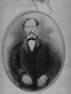

Elijah C. Pherson
| Birth | : | 1841 Hocking County, Ohio, USA |
| Death | : | 17 Mar 1878 Pulaski County, Indiana, USA |
| Burial | : | Holy Trinity Churchyard, Coverham, Richmondshire District, England |
| Coordinate | : | 54.2727230, -1.8429440 |
| Description | : | 1st. wife Harriet Johnson Pherson b 1849 Elijah was a son of George W. and Sarah (Lytle) Pherson, who both died in Pulaski Co., Indiana. Elijah served with the 25th Illinois Infantry and the U.S. 4th Calvary during the Civil War. He wrote letters home that are still treasured by his family. He was captured by the Confederate States Army and was imprisoned at Andersonville, Ga. and Florence, S.C. Contributor: Kitty Pherson (47551295) • [email protected] |
frequently asked questions (FAQ):
-
Where is Elijah C. Pherson's memorial?
Elijah C. Pherson's memorial is located at: Holy Trinity Churchyard, Coverham, Richmondshire District, England.
-
When did Elijah C. Pherson death?
Elijah C. Pherson death on 17 Mar 1878 in Pulaski County, Indiana, USA
-
Where are the coordinates of the Elijah C. Pherson's memorial?
Latitude: 54.2727230
Longitude: -1.8429440
Family Members:
Spouse
Children
Flowers:


Nearby Cemetories:
1. Holy Trinity Churchyard
Coverham, Richmondshire District, England
Coordinate: 54.2727230, -1.8429440
2. Coverham Abbey
Coverham, Richmondshire District, England
Coordinate: 54.2728510, -1.8392460
3. St. Mary and St. Alkelda Churchyard
Middleham, Richmondshire District, England
Coordinate: 54.2864000, -1.8074000
4. Wensley Cemetery
Wensley, Richmondshire District, England
Coordinate: 54.3013320, -1.8568169
5. Holy Trinity Churchyard
Wensley, Richmondshire District, England
Coordinate: 54.3014000, -1.8600000
6. Leyburn Cemetery
Leyburn, Richmondshire District, England
Coordinate: 54.3093030, -1.8348630
7. Spennithorne & Harmby Cemetery
Harmby, Richmondshire District, England
Coordinate: 54.3002500, -1.7989900
8. St Michael and All Angels Churchyard Spennithorne
Spennithorne, Richmondshire District, England
Coordinate: 54.2960200, -1.7910200
9. St John the Evangelist Churchyard
East Witton, Richmondshire District, England
Coordinate: 54.2696020, -1.7760850
10. St Simon and St Jude Roman Catholic Churchyard
Ulshaw Bridge, Richmondshire District, England
Coordinate: 54.2809800, -1.7771600
11. St Bartholomew Churchyard
West Witton, Richmondshire District, England
Coordinate: 54.2920100, -1.9073200
12. Preston Under Scar Cemetery
Preston-under-Scar, Richmondshire District, England
Coordinate: 54.3133800, -1.8964000
13. St John the Evangelist Churchyard
Bellerby, Richmondshire District, England
Coordinate: 54.3303200, -1.8239000
14. St. Oswald's Churchyard
Thornton Steward, Richmondshire District, England
Coordinate: 54.2776700, -1.7398000
15. St Mary Churchyard
Redmire, Richmondshire District, England
Coordinate: 54.3126200, -1.9227400
16. Jervaulx Abbey
East Witton, Richmondshire District, England
Coordinate: 54.2670280, -1.7379870
17. St Botolph Churchyard
Horsehouse, Richmondshire District, England
Coordinate: 54.2269100, -1.9292300
18. St. Andrew Churchyard
Aysgarth, Richmondshire District, England
Coordinate: 54.2922340, -1.9833760
19. St. Andrew's Churchyard
Finghall, Richmondshire District, England
Coordinate: 54.3068300, -1.7085500
20. St. Paul's Churchyard
Healey, Harrogate Borough, England
Coordinate: 54.2211220, -1.7208450
21. St Oswald Churchyard
Hauxwell, Richmondshire District, England
Coordinate: 54.3333300, -1.7333300
22. Friends Meeting House Burial Ground
Carperby, Richmondshire District, England
Coordinate: 54.3031720, -1.9925670
23. Low Ellington Friends Burial Ground
Harrogate Borough, England
Coordinate: 54.2488730, -1.6896440
24. St Michael and All Angels Churchyard
Downholme, Richmondshire District, England
Coordinate: 54.3799700, -1.8313400