
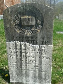
Elisabeth "Louisa" Jolly Shade
| Birth | : | 23 Dec 1817 Virginia, USA |
| Death | : | 10 Sep 1862 Berkeley County, West Virginia, USA |
| Burial | : | Pine Grove United Methodist Church Cemetery, De Haven, Frederick County, USA |
| Coordinate | : | 39.3513985, -78.1857986 |
frequently asked questions (FAQ):
-
Where is Elisabeth "Louisa" Jolly Shade's memorial?
Elisabeth "Louisa" Jolly Shade's memorial is located at: Pine Grove United Methodist Church Cemetery, De Haven, Frederick County, USA.
-
When did Elisabeth "Louisa" Jolly Shade death?
Elisabeth "Louisa" Jolly Shade death on 10 Sep 1862 in Berkeley County, West Virginia, USA
-
Where are the coordinates of the Elisabeth "Louisa" Jolly Shade's memorial?
Latitude: 39.3513985
Longitude: -78.1857986
Family Members:
Spouse
Children


Nearby Cemetories:
1. Pine Grove United Methodist Church Cemetery
De Haven, Frederick County, USA
Coordinate: 39.3513985, -78.1857986
2. Brannon Cemetery
Glengary, Berkeley County, USA
Coordinate: 39.3626100, -78.1798300
3. Howards Chapel United Methodist Church Cemetery
Siler, Frederick County, USA
Coordinate: 39.3585014, -78.2171021
4. Mount Carmel Methodist Church Cemetery
Glengary, Berkeley County, USA
Coordinate: 39.3908950, -78.1887700
5. Strowbridge Cemetery
Siler, Frederick County, USA
Coordinate: 39.3635530, -78.2354260
6. Chestnut Grove Cemetery
Siler, Frederick County, USA
Coordinate: 39.3306007, -78.2304001
7. Moutainview Baptist Church Cemetery
Glengary, Berkeley County, USA
Coordinate: 39.3853500, -78.1561500
8. Mount Pleasant Cemetery
Gerrardstown, Berkeley County, USA
Coordinate: 39.3338730, -78.1343120
9. Mount Olive Cemetery
Gerrardstown, Berkeley County, USA
Coordinate: 39.3647780, -78.1253350
10. Old Stone Church Cemetery
Green Spring, Frederick County, USA
Coordinate: 39.3011017, -78.1675034
11. Kaes Park
Frederick County, USA
Coordinate: 39.3218200, -78.2454900
12. Heironimus Gravesite
Siler, Frederick County, USA
Coordinate: 39.3558899, -78.2574669
13. Roe Chapel Cemetery
Berkeley County, USA
Coordinate: 39.4074650, -78.1849660
14. Shockeysville United Methodist Church Cemetery
Shockeysville, Frederick County, USA
Coordinate: 39.3861008, -78.2432022
15. Weidman - Suver Cemetery
Bunker Hill, Berkeley County, USA
Coordinate: 39.3335340, -78.1162690
16. Files Chapel Cemetery
Shockeysville, Frederick County, USA
Coordinate: 39.3781013, -78.2515335
17. Ganotown United Methodist Church Cemetery
Glengary, Berkeley County, USA
Coordinate: 39.4056900, -78.1492000
18. White Hall United Methodist Church Cemetery
White Hall, Frederick County, USA
Coordinate: 39.2937012, -78.1489029
19. Pleasant Valley United Methodist Church Cemetery
Cedar Grove, Frederick County, USA
Coordinate: 39.2834015, -78.1800995
20. Gerrardstown Presbyterian Church Cemetery
Gerrardstown, Berkeley County, USA
Coordinate: 39.3692398, -78.0989532
21. Central Chapel Cemetery
Hedgesville, Berkeley County, USA
Coordinate: 39.4151993, -78.1471024
22. Lutheran Cemetery
Gerrardstown, Berkeley County, USA
Coordinate: 39.3735008, -78.0972977
23. Little Mountain United Methodist Church Cemetery
Cedar Grove, Frederick County, USA
Coordinate: 39.2728004, -78.1891022
24. Buck Hill Bible Church Cemetery
Berkeley County, USA
Coordinate: 39.4138500, -78.1124900