
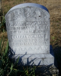
Eliza I. Zolman Zolman
| Birth | : | 29 Oct 1842 St. Francois County, Missouri, USA |
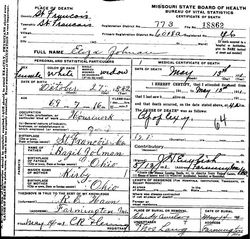
| Death | : | 13 May 1911 St. Francois County, Missouri, USA |
| Burial | : | St John the Evangelist Churchyard, Hildenborough, Tonbridge and Malling Borough, England |
| Coordinate | : | 51.2174100, 0.2391660 |
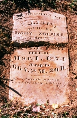
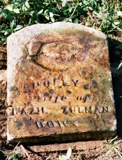
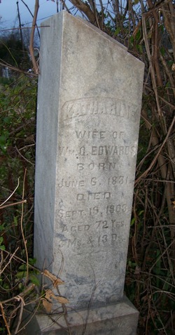
| Description | : | Eliza I. Zolman was the daughter of Basil & Mary "Polly" (nee Kirby) Zolman. She married Thomas Zolman, son of Uncle William & Aunt Hannah (nee Meloy) Zolman. Thomas & Eliza were just not husband & wife, but also first cousins. They were the parents to Morris Corbit, Mary Ellen, and Elizabeth E. |
frequently asked questions (FAQ):
-
Where is Eliza I. Zolman Zolman's memorial?
Eliza I. Zolman Zolman's memorial is located at: St John the Evangelist Churchyard, Hildenborough, Tonbridge and Malling Borough, England.
-
When did Eliza I. Zolman Zolman death?
Eliza I. Zolman Zolman death on 13 May 1911 in St. Francois County, Missouri, USA
-
Where are the coordinates of the Eliza I. Zolman Zolman's memorial?
Latitude: 51.2174100
Longitude: 0.2391660
Family Members:
Parent
Spouse

Siblings
Children

Flowers:


Nearby Cemetories:
1. St John the Evangelist Churchyard
Hildenborough, Tonbridge and Malling Borough, England
Coordinate: 51.2174100, 0.2391660
2. Hildenborough War Memorial
Hildenborough, Tonbridge and Malling Borough, England
Coordinate: 51.2175827, 0.2372410
3. St. Mary's Churchyard
Leigh, Sevenoaks District, England
Coordinate: 51.1977660, 0.2151510
4. Tonbridge Cemetery
Tonbridge, Tonbridge and Malling Borough, England
Coordinate: 51.2057762, 0.2772440
5. St. Margaret's Churchyard
Underriver, Sevenoaks District, England
Coordinate: 51.2458191, 0.2291520
6. Tonbridge Castle
Tonbridge, Tonbridge and Malling Borough, England
Coordinate: 51.1987000, 0.2764000
7. St Peter and St Paul Church
Tonbridge, Tonbridge and Malling Borough, England
Coordinate: 51.1977660, 0.2764630
8. St Stephens
Tonbridge, Tonbridge and Malling Borough, England
Coordinate: 51.1893961, 0.2687135
9. St Giles Churchyard
Shipbourne, Tonbridge and Malling Borough, England
Coordinate: 51.2471700, 0.2786090
10. St Luke Churchyard
Chiddingstone Causeway, Sevenoaks District, England
Coordinate: 51.1974910, 0.1758540
11. Ightham Mote
Ightham, Tonbridge and Malling Borough, England
Coordinate: 51.2584610, 0.2695830
12. St. Lawrence Churchyard
Bidborough, Tunbridge Wells Borough, England
Coordinate: 51.1666950, 0.2371870
13. Southborough War Memorial
Southborough, Tunbridge Wells Borough, England
Coordinate: 51.1639214, 0.2528920
14. Plaxtol Parish Churchyard
Plaxtol, Tonbridge and Malling Borough, England
Coordinate: 51.2593498, 0.2945710
15. Plaxtol War Memorial
Plaxtol, Tonbridge and Malling Borough, England
Coordinate: 51.2592888, 0.2948450
16. St. Peter's Churchyard
Southborough, Tunbridge Wells Borough, England
Coordinate: 51.1626549, 0.2520690
17. St. John the Baptist Churchyard
Penshurst, Sevenoaks District, England
Coordinate: 51.1735240, 0.1834540
18. Holy Trinity Churchyard
Crockham Hill, Sevenoaks District, England
Coordinate: 51.1982790, 0.1538090
19. St Nicholas Churchyard
Sevenoaks, Sevenoaks District, England
Coordinate: 51.2673310, 0.1933100
20. St. Lawrence Churchyard
Seal Chart, Sevenoaks District, England
Coordinate: 51.2742910, 0.2537250
21. Southborough Cemetery
Southborough, Tunbridge Wells Borough, England
Coordinate: 51.1592860, 0.2420140
22. All Saints Churchyard
Tudeley, Tunbridge Wells Borough, England
Coordinate: 51.1848510, 0.3186970
23. Chiddingstone Churchyard Extension
Chiddingstone, Sevenoaks District, England
Coordinate: 51.1861590, 0.1488930
24. Sevenoaks War Memorial
Sevenoaks, Sevenoaks District, England
Coordinate: 51.2761078, 0.1927860