
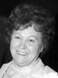
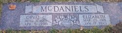
Elizabeth J. Rhodes McDaniels
| Birth | : | 28 Mar 1918 Council Bluffs, Pottawattamie County, Iowa, USA |
| Death | : | 17 Jan 2013 Pleasant Valley, Clay County, Missouri, USA |
| Burial | : | Cedar Lawn Cemetery, Council Bluffs, Pottawattamie County, USA |
| Coordinate | : | 41.2694016, -95.8182983 |
| Description | : | Elizabeth J. McDaniels, age 94, died January 17, 2013, at Pleasant Valley, Mo. She was born March 28, 1918, in Council Bluffs, Iowa, to John and Ella Rhodes. She was preceded in death by her husband, Orval G. McDaniels, Sr.; son, Orval G. "Butch" McDaniels, Jr.; and son-in-law, William H. Scheidle. Survivors include daughters, Dorothy E. Scheidle, of Surprise, Ariz., Debra A. Trimmer and husband, Joe, of Parkville, Mo.; 9 grandchildren, 9 great grandchildren, 2 great-great grandchildren; nieces and nephews. Obituary & Photo is from The Daily Nonpareil |
frequently asked questions (FAQ):
-
Where is Elizabeth J. Rhodes McDaniels's memorial?
Elizabeth J. Rhodes McDaniels's memorial is located at: Cedar Lawn Cemetery, Council Bluffs, Pottawattamie County, USA.
-
When did Elizabeth J. Rhodes McDaniels death?
Elizabeth J. Rhodes McDaniels death on 17 Jan 2013 in Pleasant Valley, Clay County, Missouri, USA
-
Where are the coordinates of the Elizabeth J. Rhodes McDaniels's memorial?
Latitude: 41.2694016
Longitude: -95.8182983
Family Members:
Spouse

Children

Flowers:


Nearby Cemetories:
1. Cedar Lawn Cemetery
Council Bluffs, Pottawattamie County, USA
Coordinate: 41.2694016, -95.8182983
2. Oak Hill Cemetery
Council Bluffs, Pottawattamie County, USA
Coordinate: 41.2700900, -95.8226400
3. Saint Joseph Cemetery
Council Bluffs, Pottawattamie County, USA
Coordinate: 41.2722015, -95.8208008
4. Bikhor Cholim Cemetery
Council Bluffs, Pottawattamie County, USA
Coordinate: 41.2703670, -95.8229350
5. Green Valley Cemetery
Council Bluffs, Pottawattamie County, USA
Coordinate: 41.2743988, -95.8225021
6. Walnut Hill Cemetery
Council Bluffs, Pottawattamie County, USA
Coordinate: 41.2719002, -95.8255997
7. Ridgewood Cemetery
Council Bluffs, Pottawattamie County, USA
Coordinate: 41.2694016, -95.8272018
8. Memorial Park Cemetery
Council Bluffs, Pottawattamie County, USA
Coordinate: 41.2644005, -95.8261032
9. Clark Cemetery
Pottawattamie County, USA
Coordinate: 41.2551610, -95.8223390
10. Fairview Cemetery
Council Bluffs, Pottawattamie County, USA
Coordinate: 41.2703018, -95.8480988
11. Garner Cemetery
Council Bluffs, Pottawattamie County, USA
Coordinate: 41.2956161, -95.8001709
12. Stoker-Graybill Cemetery
Council Bluffs, Pottawattamie County, USA
Coordinate: 41.2532620, -95.7751770
13. Maple Grove Cemetery
Council Bluffs, Pottawattamie County, USA
Coordinate: 41.2265560, -95.8187100
14. Evans Cemetery
Crescent, Pottawattamie County, USA
Coordinate: 41.3255997, -95.8368988
15. Lewis Township Cemetery
Council Bluffs, Pottawattamie County, USA
Coordinate: 41.2117004, -95.7938995
16. Gregg Cemetery
Weston, Pottawattamie County, USA
Coordinate: 41.3330000, -95.7931000
17. Council Point Cemetery
Council Bluffs, Pottawattamie County, USA
Coordinate: 41.2110830, -95.8788610
18. Hazel Dell Cemetery
Council Bluffs, Pottawattamie County, USA
Coordinate: 41.3489723, -95.7939911
19. Trinity Cathedral Columbarium
Omaha, Douglas County, USA
Coordinate: 41.2603900, -95.9393660
20. Saint Columbanus Cemetery
Weston, Pottawattamie County, USA
Coordinate: 41.3429440, -95.7435260
21. Crescent Cemetery
Crescent, Pottawattamie County, USA
Coordinate: 41.3664894, -95.8566208
22. Prospect Hill Cemetery
Omaha, Douglas County, USA
Coordinate: 41.2780991, -95.9593964
23. Saint Pauls Evangelical Country Church Cemetery
Dumfries, Pottawattamie County, USA
Coordinate: 41.1748352, -95.7492371
24. First Central Congregational Columbarium
Omaha, Douglas County, USA
Coordinate: 41.2563456, -95.9658365