
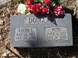
Elizabeth Ruth Warren Douglas
| Birth | : | 4 Jun 1932 Perry County, Tennessee, USA |
| Death | : | 16 Sep 2008 Corning, Clay County, Arkansas, USA |
| Burial | : | Shiffler Cemetery, Jefferson Township, Williams County, USA |
| Coordinate | : | 41.5325012, -84.5063934 |
frequently asked questions (FAQ):
-
Where is Elizabeth Ruth Warren Douglas's memorial?
Elizabeth Ruth Warren Douglas's memorial is located at: Shiffler Cemetery, Jefferson Township, Williams County, USA.
-
When did Elizabeth Ruth Warren Douglas death?
Elizabeth Ruth Warren Douglas death on 16 Sep 2008 in Corning, Clay County, Arkansas, USA
-
Where are the coordinates of the Elizabeth Ruth Warren Douglas's memorial?
Latitude: 41.5325012
Longitude: -84.5063934
Family Members:
Parent

Spouse

Siblings

Children

Flowers:


Nearby Cemetories:
1. Shiffler Cemetery
Jefferson Township, Williams County, USA
Coordinate: 41.5325012, -84.5063934
2. Old Pulaski Cemetery
Williams County, USA
Coordinate: 41.5135994, -84.5119019
3. Williams County Infirmary Cemetery
West Unity, Williams County, USA
Coordinate: 41.5571430, -84.5097860
4. Kunkle Cemetery
Williams County, USA
Coordinate: 41.5561150, -84.4762400
5. Bodel Cemetery
Stryker, Williams County, USA
Coordinate: 41.5277080, -84.4495600
6. Bechtol Cemetery #2
Montpelier, Williams County, USA
Coordinate: 41.5782060, -84.5391850
7. French Cemetery
Springfield Township, Williams County, USA
Coordinate: 41.5039100, -84.4485500
8. Beaver Creek Cemetery
Williams County, USA
Coordinate: 41.4808006, -84.4858017
9. West Jefferson Cemetery
West Jefferson, Williams County, USA
Coordinate: 41.5764008, -84.5563965
10. West Bethesda Cemetery
West Jefferson, Williams County, USA
Coordinate: 41.5422700, -84.5941200
11. Lick Creek Cemetery
Bryan, Williams County, USA
Coordinate: 41.5135994, -84.5927963
12. Lash Cemetery
Williams County, USA
Coordinate: 41.5868988, -84.5597000
13. Bistline Cemetery
West Unity, Williams County, USA
Coordinate: 41.5995650, -84.4909490
14. Oakwood Cemetery
Stryker, Williams County, USA
Coordinate: 41.4978900, -84.4274700
15. Beaver Creek Cemetery
West Unity, Williams County, USA
Coordinate: 41.6011009, -84.4738998
16. Boynton Cemetery
Stryker, Williams County, USA
Coordinate: 41.4782982, -84.4389038
17. Mary Bechtol Gravesite
Montpelier, Williams County, USA
Coordinate: 41.5575900, -84.6034900
18. Floral Grove Cemetery
West Unity, Williams County, USA
Coordinate: 41.5708008, -84.4158020
19. Bechtol Cemetery
Montpelier, Williams County, USA
Coordinate: 41.5714490, -84.6005000
20. Fountain Grove Cemetery
Bryan, Williams County, USA
Coordinate: 41.4572182, -84.5480576
21. Brown Cemetery
Bryan, Williams County, USA
Coordinate: 41.4822006, -84.5935974
22. Louden Cemetery
Montpelier, Williams County, USA
Coordinate: 41.5758018, -84.6006012
23. Rings Cemetery
West Unity, Williams County, USA
Coordinate: 41.5928680, -84.4288400
24. Lockport Cemetery
Stryker, Williams County, USA
Coordinate: 41.5466690, -84.3927765