
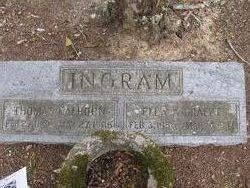
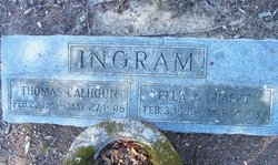
Ellen Ann “Ella” Grafft Ingram
| Birth | : | 3 Feb 1856 Cheraw, Chesterfield County, South Carolina, USA |
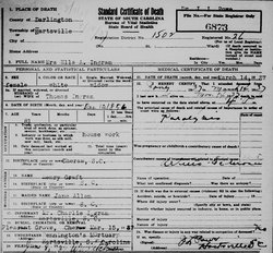
| Death | : | 14 Mar 1937 Hartsville, Darlington County, South Carolina, USA |
| Burial | : | Pleasant Grove United Methodist Church Cemetery, Cheraw, Chesterfield County, USA |
| Coordinate | : | 34.7048630, -79.9539520 |
| Description | : | Error on death certificate; listed on the 1860 census with parents of Samuel Grafft born PA; mother was already deceased; moved to SC between 1847 and 1849 according to where the children were born Ella's brother: Arden Edward Grafft is buried in Texas |
frequently asked questions (FAQ):
-
Where is Ellen Ann “Ella” Grafft Ingram's memorial?
Ellen Ann “Ella” Grafft Ingram's memorial is located at: Pleasant Grove United Methodist Church Cemetery, Cheraw, Chesterfield County, USA.
-
When did Ellen Ann “Ella” Grafft Ingram death?
Ellen Ann “Ella” Grafft Ingram death on 14 Mar 1937 in Hartsville, Darlington County, South Carolina, USA
-
Where are the coordinates of the Ellen Ann “Ella” Grafft Ingram's memorial?
Latitude: 34.7048630
Longitude: -79.9539520
Family Members:
Spouse
Children

Flowers:


Nearby Cemetories:
1. Pleasant Grove United Methodist Church Cemetery
Cheraw, Chesterfield County, USA
Coordinate: 34.7048630, -79.9539520
2. Prince Of Peace Church Cemetery
Cheraw, Chesterfield County, USA
Coordinate: 34.7076230, -79.9484660
3. Smithville Cemetery
Chesterfield County, USA
Coordinate: 34.7047005, -79.9669037
4. Saint Paul Missionary Baptist Church
Cheraw, Chesterfield County, USA
Coordinate: 34.7109260, -79.9745410
5. Saint Josephs Cemetery
Cheraw, Chesterfield County, USA
Coordinate: 34.7175410, -79.9702010
6. Progressive Church of Our Lord Jesus Christ Cemete
Cheraw, Chesterfield County, USA
Coordinate: 34.6910300, -79.9387430
7. Midway Baptist Church Cemetery
Cheraw, Chesterfield County, USA
Coordinate: 34.7170570, -79.9826580
8. Robinson Zion Church
Cheraw, Chesterfield County, USA
Coordinate: 34.7328090, -79.9323420
9. J. C. Broome Memorial Garden
Cheraw, Chesterfield County, USA
Coordinate: 34.6753830, -79.9346970
10. Faith Freewill Baptist Church Cemetery
Cheraw, Chesterfield County, USA
Coordinate: 34.6717450, -79.9451980
11. Goodman Creek Missionary Baptist Church
Cheraw, Chesterfield County, USA
Coordinate: 34.7356390, -79.9347530
12. Fisher Hill Community Cemetery
Cheraw, Chesterfield County, USA
Coordinate: 34.6738360, -79.9319040
13. Foundry Hill Cemetery
Cheraw, Chesterfield County, USA
Coordinate: 34.6957350, -79.8998800
14. First Southern Methodist Church Cemetery
Cheraw, Chesterfield County, USA
Coordinate: 34.6692090, -79.9958000
15. Brock Cemetery
Brocks Mill, Chesterfield County, USA
Coordinate: 34.7503930, -79.9863370
16. Chatham Hill Memorial Gardens
Cheraw, Chesterfield County, USA
Coordinate: 34.6719017, -79.9019012
17. Mount Olivet United Methodist Church Cemetery
Hunts Mill, Chesterfield County, USA
Coordinate: 34.6623192, -79.9972763
18. Lower Macedonia Memorial Garden
Chesterfield, Chesterfield County, USA
Coordinate: 34.6688470, -80.0077090
19. Erasmus Powe Family Cemetery
Cheraw, Chesterfield County, USA
Coordinate: 34.7041400, -79.8822950
20. Brocks Mill Baptist Church Cemetery Annex
Brocks Mill, Chesterfield County, USA
Coordinate: 34.7578990, -79.9919590
21. Brocks Mill Baptist Church Cemetery
Chesterfield, Chesterfield County, USA
Coordinate: 34.7582730, -79.9917660
22. Old Saint Davids Episcopal Church Cemetery
Cheraw, Chesterfield County, USA
Coordinate: 34.6956140, -79.8794250
23. Pee Dee Union Baptist Church Cemetery
Cheraw, Chesterfield County, USA
Coordinate: 34.6968440, -79.8775160
24. Southern Grace Church
Chesterfield, Chesterfield County, USA
Coordinate: 34.7234820, -80.0300720