
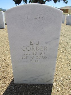
Elma Jean “EJ” Stuart Corder
| Birth | : | 28 Jul 1917 Ford, Ford County, Kansas, USA |
| Death | : | 10 Sep 2009 Fort Mohave, Mohave County, Arizona, USA |
| Burial | : | Bakersfield National Cemetery, Arvin, Kern County, USA |
| Coordinate | : | 35.2559600, -118.6693480 |
| Description | : | In 1937 EJ married Rolfe Curtis and together they had three sons, Stuart, Douglas and Dallas. The Curtis family grew up in Dodge City, Kan., and in the late 1940's, EJ and Rolfe created Curtis Machine Company. Working side by side, EJ and Rolfe built Curtis Machine Company into the largest employer in Dodge City. The company was known worldwide for the precision gearboxes, winches and transmissions that were all designed and built by Rolfe. EJ was the bookkeeper for the company and worked tirelessly with Rolfe to build the company into the international company that it became. In... Read More |
frequently asked questions (FAQ):
-
Where is Elma Jean “EJ” Stuart Corder's memorial?
Elma Jean “EJ” Stuart Corder's memorial is located at: Bakersfield National Cemetery, Arvin, Kern County, USA.
-
When did Elma Jean “EJ” Stuart Corder death?
Elma Jean “EJ” Stuart Corder death on 10 Sep 2009 in Fort Mohave, Mohave County, Arizona, USA
-
Where are the coordinates of the Elma Jean “EJ” Stuart Corder's memorial?
Latitude: 35.2559600
Longitude: -118.6693480
Family Members:
Parent

Spouse
Siblings
Flowers:


Nearby Cemetories:
1. Bakersfield National Cemetery
Arvin, Kern County, USA
Coordinate: 35.2559600, -118.6693480
2. Fickert Family Cemetery
Bear Valley Springs, Kern County, USA
Coordinate: 35.1697260, -118.6443350
3. Cesar E. Chavez National Monument
Keene, Kern County, USA
Coordinate: 35.2236000, -118.5592400
4. Tehachapi Cove Cemetery
Tehachapi, Kern County, USA
Coordinate: 35.1190000, -118.5724600
5. Rankin Cemetery
Walker Basin, Kern County, USA
Coordinate: 35.3844560, -118.5388890
6. Brite Family Cemetery
Tehachapi, Kern County, USA
Coordinate: 35.1085350, -118.5473470
7. Arvin Cemetery
Arvin, Kern County, USA
Coordinate: 35.2132300, -118.8952700
8. Old Tehachapi Cemetery
Tehachapi, Kern County, USA
Coordinate: 35.1400990, -118.4795570
9. Paris-Loraine Cemetery
Loraine, Kern County, USA
Coordinate: 35.3059000, -118.4355000
10. Tehachapi Westside Cemetery
Tehachapi, Kern County, USA
Coordinate: 35.1387400, -118.4633600
11. Tejon Indian Settlement Cemetery
Kern County, USA
Coordinate: 35.0422000, -118.6553900
12. Hillcrest Memorial Park
Bakersfield, Kern County, USA
Coordinate: 35.3814316, -118.9012527
13. Buhn Ranch Cemetery
Tehachapi, Kern County, USA
Coordinate: 35.1352210, -118.4319290
14. Williams Burial Site
Walker Basin, Kern County, USA
Coordinate: 35.4320950, -118.4815680
15. Tehachapi Eastside Cemetery
Tehachapi, Kern County, USA
Coordinate: 35.1329000, -118.4153200
16. Kuntz Ranch Cemetery
Bakersfield, Kern County, USA
Coordinate: 35.4373560, -118.9390180
17. Saint Joseph Cemetery
Havilah, Kern County, USA
Coordinate: 35.5147500, -118.5177700
18. Union Cemetery
Bakersfield, Kern County, USA
Coordinate: 35.3646500, -118.9948700
19. Home of Peace Jewish Cemetery
Bakersfield, Kern County, USA
Coordinate: 35.3631500, -118.9987400
20. Greenlawn Cemetery and Mortuary
Bakersfield, Kern County, USA
Coordinate: 35.4067001, -118.9856033
21. Greenlawn Southwest Mortuary and Cemetery
Bakersfield, Kern County, USA
Coordinate: 35.2948990, -119.0330810
22. Chinese Cemetery
Bakersfield, Kern County, USA
Coordinate: 35.3510550, -119.0273380
23. Sand Canyon Cemetery
Tehachapi, Kern County, USA
Coordinate: 35.1331320, -118.3150210
24. Saint Pauls Episcopal Church Columbarium
Bakersfield, Kern County, USA
Coordinate: 35.3746120, -119.0277940