
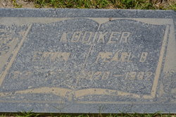
| Birth | : | 6 May 1924 Ashton, Osceola County, Iowa, USA |
| Death | : | 23 Sep 2008 Missouri Valley, Harrison County, Iowa, USA |
| Burial | : | Branson Cemetery, Loveland, Pottawattamie County, USA |
| Coordinate | : | 41.4846992, -95.8606033 |
| Description | : | Elmer B. Kooiker, age 84, passed away on Tuesday, September 23, 2008, at Community Memorial Hospital in Missouri Valley. Elmer was born on May 6, 1924, to Ralph and Jenny (Vanderwierd) Kooiker in Ashton. He married Celia Richardson on February 25, 1948, in Rock Valley. Elmer served his country in the Navy during WWII. He was a carpenter for many years. Elmer enjoyed fishing, gardening, playing bingo and cards. Survivors include his wife, Celia, of Missouri Valley; daughters, Rhonda and husband Ronald Nordby of Missouri Valley, Cherie Hauser of Rock Springs, Wyo., Loma and husband Ron Green of... Read More |
frequently asked questions (FAQ):
-
Where is Elmer Bernard Kooiker's memorial?
Elmer Bernard Kooiker's memorial is located at: Branson Cemetery, Loveland, Pottawattamie County, USA.
-
When did Elmer Bernard Kooiker death?
Elmer Bernard Kooiker death on 23 Sep 2008 in Missouri Valley, Harrison County, Iowa, USA
-
Where are the coordinates of the Elmer Bernard Kooiker's memorial?
Latitude: 41.4846992
Longitude: -95.8606033
Family Members:
Parent

Spouse
Siblings

Flowers:


Nearby Cemetories:
1. Branson Cemetery
Loveland, Pottawattamie County, USA
Coordinate: 41.4846992, -95.8606033
2. Crook Cemetery
Honey Creek, Pottawattamie County, USA
Coordinate: 41.4581330, -95.8737000
3. Saint Bridgets Cemetery
Honey Creek, Pottawattamie County, USA
Coordinate: 41.4664001, -95.8289032
4. Oak Grove Cemetery
Missouri Valley, Harrison County, USA
Coordinate: 41.5167007, -95.8649979
5. Allen Cemetery
Pottawattamie County, USA
Coordinate: 41.4427986, -95.8550034
6. Grange Cemetery
Honey Creek, Pottawattamie County, USA
Coordinate: 41.4446678, -95.8034668
7. Reels Cemetery
Crescent, Pottawattamie County, USA
Coordinate: 41.4234100, -95.8321700
8. William C McIntosh Cemetery
Crescent, Pottawattamie County, USA
Coordinate: 41.4088745, -95.8477097
9. Rose Hill Memorial Gardens
Missouri Valley, Harrison County, USA
Coordinate: 41.5656000, -95.8897000
10. Hurleys Evergreen Cemetery
Harrison County, USA
Coordinate: 41.5700989, -95.8618698
11. Mount Carmel Cemetery
Missouri Valley, Harrison County, USA
Coordinate: 41.5675011, -95.8897018
12. Saint Pauls Lutheran Cemetery
Neola, Pottawattamie County, USA
Coordinate: 41.4337000, -95.7607000
13. Champan Frazier Cemetery
Harrison County, USA
Coordinate: 41.5773500, -95.8933500
14. Frazier Cemetery
Missouri Valley, Harrison County, USA
Coordinate: 41.5932999, -95.8375015
15. Linnwood Cemetery
Harrison County, USA
Coordinate: 41.5589200, -95.7502100
16. Crescent Cemetery
Crescent, Pottawattamie County, USA
Coordinate: 41.3664894, -95.8566208
17. Shipley Cemetery
Washington County, USA
Coordinate: 41.3932991, -95.9828033
18. Fort Calhoun Cemetery
Fort Calhoun, Washington County, USA
Coordinate: 41.4581375, -96.0352020
19. Harris Grove Cemetery
Beebeetown, Harrison County, USA
Coordinate: 41.5782928, -95.7262192
20. Hazel Dell Cemetery
Council Bluffs, Pottawattamie County, USA
Coordinate: 41.3489723, -95.7939911
21. Castor Cemetery
Underwood, Pottawattamie County, USA
Coordinate: 41.4127040, -95.6887490
22. Calhoun Cemetery
Calhoun, Harrison County, USA
Coordinate: 41.6391983, -95.8938980
23. Gregg Cemetery
Weston, Pottawattamie County, USA
Coordinate: 41.3330000, -95.7931000
24. Evans Cemetery
Crescent, Pottawattamie County, USA
Coordinate: 41.3255997, -95.8368988