
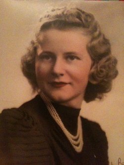


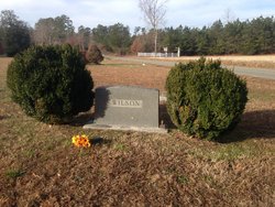
Eloise Wilson Fary
| Birth | : | 23 Mar 1922 Virginia, USA |
| Death | : | 4 Oct 2005 |
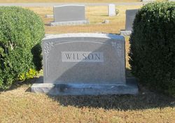
| Burial | : | Olive Branch United Methodist Church Cemetery, Harcum, Gloucester County, USA |
| Coordinate | : | 37.5070790, -76.5191580 |
| Description | : | GLOUCESTER — Eloise W. Fary, 83, of Gloucester, passed away on Tuesday, Oct. 4, 2005, in Riverside Regional Medical Center. She was the widow of Emmett Randolph Fary Sr. Born and raised on the Piankatank River at Deep Point she was the youngest of six children of the late Ethelbert and Mamie Roane Wilson . Besides being a loving, dedicated mother and grandmother she was an insurance underwriter/office manager for Southside Insurance Agency for many years. As a creative homemaker, her talents included baking, cake decorating, flower arranging, sewing, and upholstering. Before her declining health she had been an active member of Olive... Read More |
frequently asked questions (FAQ):
-
Where is Eloise Wilson Fary's memorial?
Eloise Wilson Fary's memorial is located at: Olive Branch United Methodist Church Cemetery, Harcum, Gloucester County, USA.
-
When did Eloise Wilson Fary death?
Eloise Wilson Fary death on 4 Oct 2005 in
-
Where are the coordinates of the Eloise Wilson Fary's memorial?
Latitude: 37.5070790
Longitude: -76.5191580
Family Members:
Parent

Spouse
Siblings

Flowers:


Nearby Cemetories:
1. Ebenezer Baptist Church Cemetery
Gloucester, Gloucester County, USA
Coordinate: 37.4989000, -76.5308960
2. Gleaning Baptist Church Cemetery
Harcum, Gloucester County, USA
Coordinate: 37.5151120, -76.4972470
3. Zion Hill Baptist Church Cemetery
Gloucester, Gloucester County, USA
Coordinate: 37.4840290, -76.5263470
4. New Mount Zion Baptist Church Cemetery
Gloucester County, USA
Coordinate: 37.5112070, -76.5924850
5. Barn Elms Plantation Cemetery
Middlesex County, USA
Coordinate: 37.5435146, -76.4572527
6. Rising Valley Baptist Church Cemetery
Gloucester County, USA
Coordinate: 37.4663940, -76.4589210
7. Salem United Methodist Church Cemetery
Gloucester, Gloucester County, USA
Coordinate: 37.5283210, -76.5938500
8. Windsor Gardens Cemetery
Mathews, Mathews County, USA
Coordinate: 37.4808390, -76.4458140
9. Grafton Baptist Church Cemetery
Hartfield, Middlesex County, USA
Coordinate: 37.5594100, -76.4698150
10. Lower United Methodist Church Cemetery
Hartfield, Middlesex County, USA
Coordinate: 37.5525990, -76.4584960
11. Locust Grove United Methodist Church Cemetery
Soles, Mathews County, USA
Coordinate: 37.4897570, -76.4385580
12. Windsor Road Family Cemetery
Dutton, Gloucester County, USA
Coordinate: 37.4837990, -76.4406860
13. Mount Zion United Methodist Church Cemetery
Gloucester, Gloucester County, USA
Coordinate: 37.4506600, -76.4724080
14. Holland Point Cemetery
Mathews, Mathews County, USA
Coordinate: 37.5094400, -76.4338900
15. Shepherdsville Baptist Church Cemetery
Gloucester County, USA
Coordinate: 37.4509200, -76.5684680
16. Church of the Visitation Cemetery
Topping, Middlesex County, USA
Coordinate: 37.5717930, -76.4854130
17. Mount Olive Church Cemetery
Harfield, Middlesex County, USA
Coordinate: 37.5410570, -76.4327490
18. Harmony Grove Baptist Church Cemetery
Topping, Middlesex County, USA
Coordinate: 37.5809160, -76.4876420
19. Petsworth Parish Episcopal Church Cemetery
Gloucester County, USA
Coordinate: 37.4637186, -76.6046384
20. Grace Bible Church Cemetery
Ark, Gloucester County, USA
Coordinate: 37.4411260, -76.5790070
21. Spring Hill Baptist Church Cemetery
Cobbs Creek, Mathews County, USA
Coordinate: 37.4936730, -76.4160275
22. First Baptist Church of Harmony Village Cemetery
Harmony Village, Middlesex County, USA
Coordinate: 37.5873840, -76.4905660
23. Ware Episcopal Church Cemetery
Gloucester, Gloucester County, USA
Coordinate: 37.4227470, -76.5078880
24. Unnamed Colonial Era Farm Cemetery
Owl Trap, Gloucester County, USA
Coordinate: 37.5239449, -76.6276016