

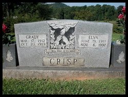
Elva Hazel Elliott Crisp
| Birth | : | 19 Jun 1915 |
| Death | : | 6 Nov 1997 |
| Burial | : | St Andrew Churchyard, Denton, South Kesteven District, England |
| Coordinate | : | 52.8828830, -0.7151840 |
| Description | : | Wife of Henry Grady Crisp |
frequently asked questions (FAQ):
-
Where is Elva Hazel Elliott Crisp's memorial?
Elva Hazel Elliott Crisp's memorial is located at: St Andrew Churchyard, Denton, South Kesteven District, England.
-
When did Elva Hazel Elliott Crisp death?
Elva Hazel Elliott Crisp death on 6 Nov 1997 in
-
Where are the coordinates of the Elva Hazel Elliott Crisp's memorial?
Latitude: 52.8828830
Longitude: -0.7151840
Family Members:
Spouse
Flowers:


Nearby Cemetories:
1. St Andrew Churchyard
Denton, South Kesteven District, England
Coordinate: 52.8828830, -0.7151840
2. St Mary and St Peter Churchyard
Harlaxton, South Kesteven District, England
Coordinate: 52.8836860, -0.6895640
3. St Michael & All Angels Churchyard
Harston, Melton Borough, England
Coordinate: 52.8769700, -0.7556000
4. St James Churchyard
Woolsthorpe-by-Belvoir, South Kesteven District, England
Coordinate: 52.8957880, -0.7578370
5. All Saints Churchyard
Stroxton, South Kesteven District, England
Coordinate: 52.8695300, -0.6609700
6. All Saints Churchyard
Barrowby, South Kesteven District, England
Coordinate: 52.9186420, -0.6946810
7. St Botolph & St John Baptist Churchyard
Croxton Kerrial, Melton Borough, England
Coordinate: 52.8565120, -0.7608620
8. All Saints Churchyard
Knipton, South Kesteven District, England
Coordinate: 52.8711300, -0.7769400
9. Belvoir Castle
Belvoir, Melton Borough, England
Coordinate: 52.8911170, -0.7855620
10. Belvoir Priory
Bottesford, Melton Borough, England
Coordinate: 52.8982090, -0.7825130
11. St. Lawrence Churchyard
Sedgebrook, South Kesteven District, England
Coordinate: 52.9329460, -0.7256530
12. St. Guthlac Churchyard
Little Ponton, South Kesteven District, England
Coordinate: 52.8796100, -0.6271200
13. St Peter's Churchyard
Saltby, Melton Borough, England
Coordinate: 52.8298400, -0.7378900
14. St. Wulfram Churchyard
Grantham, South Kesteven District, England
Coordinate: 52.9148180, -0.6408520
15. Holy Cross Churchyard
Great Ponton, South Kesteven District, England
Coordinate: 52.8638270, -0.6275570
16. Grantham Cemetery and Crematorium
Grantham, South Kesteven District, England
Coordinate: 52.9095320, -0.6326120
17. Manthorpe Road Old Cemetery
Grantham, South Kesteven District, England
Coordinate: 52.9173900, -0.6409900
18. St Guthlac Churchyard
Branston, Melton Borough, England
Coordinate: 52.8570750, -0.7988980
19. Croxton Abbey
Croxton Kerrial, Melton Borough, England
Coordinate: 52.8398910, -0.7786310
20. St John the Baptist Churchyard
Muston, Melton Borough, England
Coordinate: 52.9315700, -0.7680600
21. St Sebastian Churchyard
Great Gonerby, South Kesteven District, England
Coordinate: 52.9329260, -0.6657700
22. St James Churchyard
Skillington, South Kesteven District, England
Coordinate: 52.8231750, -0.6724600
23. St Peter Churchyard
Redmile, Melton Borough, England
Coordinate: 52.9113200, -0.8161530
24. Eaton Cemetery
Eaton, Melton Borough, England
Coordinate: 52.8544070, -0.8174640