
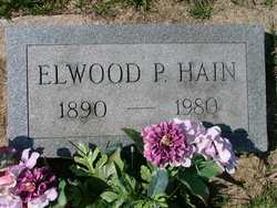
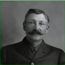
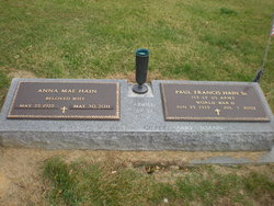
Elwood Parker Hain
| Birth | : | 20 Feb 1890 Cedar County, Iowa, USA |
| Death | : | 15 Jan 1980 Wilton, Muscatine County, Iowa, USA |
| Burial | : | Church Stretton Cemetery, Church Stretton, Shropshire Unitary Authority, England |
| Coordinate | : | 52.5365590, -2.8097950 |
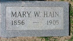
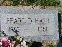
| Description | : | Elwood Hain, 89, died Tuesday at the Wilton Nursing Home. Services will be held at 2 p.m. Friday at the Gill-Lacock Funeral Home, with Rev. Larry Bunger officiating. Masonic rites will be held at 7:30 this evening at the funeral home. Visitation will be from 3:30 to 9 p.m. today at the funeral home, and from 9 a.m. Friday until the time of the service. Mr. Hain retired from farming in 1950. He was a 66-year member of the Golden Rule Lodge at Rochester. He was born Feb. 20, 1890, near Moscow, the son of Linus and Mary Blessing Hain. Mr. Hain was married to Pearl Kaufmann, Sept. 26, 1917, at Lime City, Ia. A... Read More |
frequently asked questions (FAQ):
-
Where is Elwood Parker Hain's memorial?
Elwood Parker Hain's memorial is located at: Church Stretton Cemetery, Church Stretton, Shropshire Unitary Authority, England.
-
When did Elwood Parker Hain death?
Elwood Parker Hain death on 15 Jan 1980 in Wilton, Muscatine County, Iowa, USA
-
Where are the coordinates of the Elwood Parker Hain's memorial?
Latitude: 52.5365590
Longitude: -2.8097950
Family Members:
Parent
Spouse
Siblings

Children

Flowers:


Nearby Cemetories:
1. St Laurence Churchyard
Church Stretton, Shropshire Unitary Authority, England
Coordinate: 52.5381750, -2.8087400
2. Greenhills Cemetery
Church Stretton, Shropshire Unitary Authority, England
Coordinate: 52.5310170, -2.8142480
3. St. Andrew's Churchyard
Hope Bowdler, Shropshire Unitary Authority, England
Coordinate: 52.5271160, -2.7739830
4. St Margaret's Churchyard
Acton Scott, Shropshire Unitary Authority, England
Coordinate: 52.5001670, -2.8060920
5. St. James's Churchyard
Cardington, Shropshire Unitary Authority, England
Coordinate: 52.5520200, -2.7296220
6. Eaton- under- Heywood St Edith
Eaton-under-Heywood, Shropshire Unitary Authority, England
Coordinate: 52.5056520, -2.7382880
7. Westhope Chapel Burial Ground
Diddlebury, Shropshire Unitary Authority, England
Coordinate: 52.4714690, -2.7818850
8. St. Edith's Churchyard
Church Pulverbatch, Shropshire Unitary Authority, England
Coordinate: 52.6210550, -2.8436610
9. St. Peter's Churchyard
Diddlebury, Shropshire Unitary Authority, England
Coordinate: 52.4640570, -2.7249740
10. St. Mark's Churchyard
Frodesley, Shropshire Unitary Authority, England
Coordinate: 52.6052775, -2.7166580
11. St Michael Churchyard
Edgton, Shropshire Unitary Authority, England
Coordinate: 52.4660500, -2.9044570
12. St. John the Baptist Churchyard
Church Preen, Shropshire Unitary Authority, England
Coordinate: 52.5792000, -2.6754000
13. St. Thomas' Churchyard
Craven Arms, Shropshire Unitary Authority, England
Coordinate: 52.4450630, -2.8306870
14. St. John’s Churchyard
Condover, Shropshire Unitary Authority, England
Coordinate: 52.6356110, -2.7833220
15. Habberley St Mary's Church
Atcham, Shropshire Unitary Authority, England
Coordinate: 52.6266060, -2.8897140
16. St Peter's Churchyard
Easthope, Shropshire Unitary Authority, England
Coordinate: 52.5522350, -2.6413020
17. Holy Trinity Churchyard
Holdgate, Shropshire Unitary Authority, England
Coordinate: 52.5024450, -2.6471900
18. St. Mary's Churchyard
Acton Burnell, Shropshire Unitary Authority, England
Coordinate: 52.6131390, -2.6907390
19. St Marys Churchyard
Hopesay, Shropshire Unitary Authority, England
Coordinate: 52.4440470, -2.8999020
20. St. John’s Churchyard
Hughley, Shropshire Unitary Authority, England
Coordinate: 52.5774550, -2.6435850
21. All Saints Churchyard
Culmington, Shropshire Unitary Authority, England
Coordinate: 52.4334800, -2.7463500
22. St. Mary & St. Andrew Churchyard
Condover, Shropshire Unitary Authority, England
Coordinate: 52.6474199, -2.7484076
23. St. John The Baptist Churchyard
Kenley, Shropshire Unitary Authority, England
Coordinate: 52.6030460, -2.6469840
24. Holy Trinity Churchyard
Hope, Shropshire Unitary Authority, England
Coordinate: 52.6070670, -2.9747750