

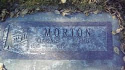
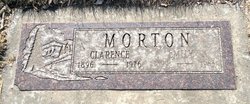
Emily “Emma” Kinney Morton
| Birth | : | 10 Aug 1899 Kalamazoo, Kalamazoo County, Michigan, USA |
| Death | : | 24 May 1983 Miles City, Custer County, Montana, USA |
| Burial | : | Southern Cemetery and Crematorium, West Bridgford, Rushcliffe Borough, England |
| Coordinate | : | 52.9113900, -1.1408500 |
| Plot | : | Section I |
| Description | : | MILES CITY -- Emily Emma Morton lived on a homestead with her husband until 1925 when they moved to the Big Horn area near Custer. In 1928 they moved to Miles City where they remained until 1960 when they went to Mesa, Ariz. They moved back to Miles City in 1975. Mrs. Morton, 83, passed away early Tuesday morning in Holy Rosary Hospital. She was born in Kalamazoo, Mich., the daughter of Frederick and Nellie Kinney. She attended schools in Michigan. She moved with her family in 1913 to Miles City and shortly after that homesteaded in the Butte Creek area in... Read More |
frequently asked questions (FAQ):
-
Where is Emily “Emma” Kinney Morton's memorial?
Emily “Emma” Kinney Morton's memorial is located at: Southern Cemetery and Crematorium, West Bridgford, Rushcliffe Borough, England.
-
When did Emily “Emma” Kinney Morton death?
Emily “Emma” Kinney Morton death on 24 May 1983 in Miles City, Custer County, Montana, USA
-
Where are the coordinates of the Emily “Emma” Kinney Morton's memorial?
Latitude: 52.9113900
Longitude: -1.1408500
Family Members:
Parent

Spouse
Siblings
Children
Flowers:


Nearby Cemetories:
1. Southern Cemetery and Crematorium
West Bridgford, Rushcliffe Borough, England
Coordinate: 52.9113900, -1.1408500
2. Jewish Cemetery
Nottingham, Nottingham Unitary Authority, England
Coordinate: 52.9123890, -1.1372670
3. Edwalton Holy Rood Churchyard
West Bridgford, Rushcliffe Borough, England
Coordinate: 52.9093000, -1.1114170
4. St. Peter's Churchyard
Ruddington, Rushcliffe Borough, England
Coordinate: 52.8925940, -1.1506460
5. Ruddington Old Cemetery
Ruddington, Rushcliffe Borough, England
Coordinate: 52.8914500, -1.1531400
6. St. Giles's Church & Churchyard
West Bridgford, Rushcliffe Borough, England
Coordinate: 52.9316460, -1.1288450
7. St Peter New Churchyard
Ruddington, Rushcliffe Borough, England
Coordinate: 52.8914800, -1.1549600
8. Flawford St Peter
Ruddington, Rushcliffe Borough, England
Coordinate: 52.8934800, -1.1201300
9. Wilford Village Cemetery
Wilford, Nottingham Unitary Authority, England
Coordinate: 52.9338540, -1.1591170
10. St. Wilfrid Churchyard
Wilford, Nottingham Unitary Authority, England
Coordinate: 52.9346290, -1.1587770
11. St Mary's Churchyard
Clifton, Nottingham Unitary Authority, England
Coordinate: 52.9083870, -1.1965435
12. St. Mary The Virgin Churchyard
Plumtree, Rushcliffe Borough, England
Coordinate: 52.8918690, -1.0874320
13. St Nicholas Churchyard
Nottingham, Nottingham Unitary Authority, England
Coordinate: 52.9504780, -1.1509220
14. National Justice Museum High Pavement Nottingham
Nottingham Unitary Authority, England
Coordinate: 52.9510680, -1.1443050
15. St Peters Church Yard
Nottingham, Nottingham Unitary Authority, England
Coordinate: 52.9522800, -1.1486940
16. National Ice Centre
Nottingham, Nottingham Unitary Authority, England
Coordinate: 52.9527790, -1.1394460
17. St Mary's Burial Grounds
Nottingham, Nottingham Unitary Authority, England
Coordinate: 52.9527860, -1.1419160
18. Holy Trinity Churchyard
Lenton, Nottingham Unitary Authority, England
Coordinate: 52.9485630, -1.1753148
19. Cathedral Church of St. Barnabas
Nottingham, Nottingham Unitary Authority, England
Coordinate: 52.9546750, -1.1570460
20. Beeston Baptist Chapel
Beeston, Broxtowe Borough, England
Coordinate: 52.9246600, -1.2122000
21. St. Mary Rest Ground
Nottingham, Nottingham Unitary Authority, England
Coordinate: 52.9568310, -1.1406580
22. General Cemetery
Nottingham, Nottingham Unitary Authority, England
Coordinate: 52.9561430, -1.1615420
23. Nottingham General Cemetery
Nottingham, Nottingham Unitary Authority, England
Coordinate: 52.9575370, -1.1594236
24. St. John the Baptist Churchyard
Beeston, Broxtowe Borough, England
Coordinate: 52.9255562, -1.2167680