
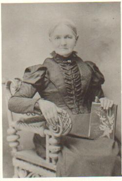
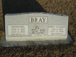

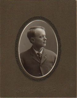
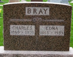
Emily Goodrich Damon Bray
| Birth | : | 6 Jan 1831 Livonia, Livingston County, New York, USA |
| Death | : | 17 Sep 1904 Syracuse, Otoe County, Nebraska, USA |
| Burial | : | Hazel Dell Cemetery, Council Bluffs, Pottawattamie County, USA |
| Coordinate | : | 41.3489723, -95.7939911 |
| Plot | : | No Headstone |
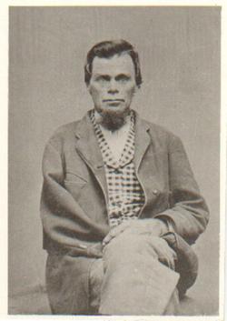
| Description | : | Emily Damon Bray died at her home near Syracuse, Saturday evening, Sept. 17, 1904, after an illness of a few weeks. Age 78 years, 8 months, and 1 day. The funeral was held from the Congregational Church, Monday Sept 19, conducted by Ref. F. F. Lewis, after which the remains were laid to rest in the Warner Cemetery. Emily Damon Bray was born in Livingston County, New York, January 15, 1831, and was married to Nathaniel Bray of Ontario Co., N>Y> in 1847. She removed from her native state to the territory of Nebraska in the fall of 1861 and... Read More |
frequently asked questions (FAQ):
-
Where is Emily Goodrich Damon Bray's memorial?
Emily Goodrich Damon Bray's memorial is located at: Hazel Dell Cemetery, Council Bluffs, Pottawattamie County, USA.
-
When did Emily Goodrich Damon Bray death?
Emily Goodrich Damon Bray death on 17 Sep 1904 in Syracuse, Otoe County, Nebraska, USA
-
Where are the coordinates of the Emily Goodrich Damon Bray's memorial?
Latitude: 41.3489723
Longitude: -95.7939911
Family Members:
Parent
Spouse
Siblings
Children

Flowers:


Nearby Cemetories:
1. Hazel Dell Cemetery
Council Bluffs, Pottawattamie County, USA
Coordinate: 41.3489723, -95.7939911
2. Gregg Cemetery
Weston, Pottawattamie County, USA
Coordinate: 41.3330000, -95.7931000
3. Saint Columbanus Cemetery
Weston, Pottawattamie County, USA
Coordinate: 41.3429440, -95.7435260
4. Evans Cemetery
Crescent, Pottawattamie County, USA
Coordinate: 41.3255997, -95.8368988
5. Crescent Cemetery
Crescent, Pottawattamie County, USA
Coordinate: 41.3664894, -95.8566208
6. Garner Cemetery
Council Bluffs, Pottawattamie County, USA
Coordinate: 41.2956161, -95.8001709
7. Downsville Cemetery
Pottawattamie County, USA
Coordinate: 41.3502998, -95.7039032
8. William C McIntosh Cemetery
Crescent, Pottawattamie County, USA
Coordinate: 41.4088745, -95.8477097
9. Green Valley Cemetery
Council Bluffs, Pottawattamie County, USA
Coordinate: 41.2743988, -95.8225021
10. Saint Joseph Cemetery
Council Bluffs, Pottawattamie County, USA
Coordinate: 41.2722015, -95.8208008
11. Reels Cemetery
Crescent, Pottawattamie County, USA
Coordinate: 41.4234100, -95.8321700
12. Walnut Hill Cemetery
Council Bluffs, Pottawattamie County, USA
Coordinate: 41.2719002, -95.8255997
13. Bikhor Cholim Cemetery
Council Bluffs, Pottawattamie County, USA
Coordinate: 41.2703670, -95.8229350
14. Cedar Lawn Cemetery
Council Bluffs, Pottawattamie County, USA
Coordinate: 41.2694016, -95.8182983
15. Oak Hill Cemetery
Council Bluffs, Pottawattamie County, USA
Coordinate: 41.2700900, -95.8226400
16. Ridgewood Cemetery
Council Bluffs, Pottawattamie County, USA
Coordinate: 41.2694016, -95.8272018
17. H G Fisher Cemetery
Underwood, Pottawattamie County, USA
Coordinate: 41.3838997, -95.6889038
18. Memorial Park Cemetery
Council Bluffs, Pottawattamie County, USA
Coordinate: 41.2644005, -95.8261032
19. Saint Pauls Lutheran Cemetery
Neola, Pottawattamie County, USA
Coordinate: 41.4337000, -95.7607000
20. Fairview Cemetery
Council Bluffs, Pottawattamie County, USA
Coordinate: 41.2703018, -95.8480988
21. Grange Cemetery
Honey Creek, Pottawattamie County, USA
Coordinate: 41.4446678, -95.8034668
22. Clark Cemetery
Pottawattamie County, USA
Coordinate: 41.2551610, -95.8223390
23. Pottawattamie County Home Cemetery
McClelland, Pottawattamie County, USA
Coordinate: 41.3269400, -95.6691738
24. Stoker-Graybill Cemetery
Council Bluffs, Pottawattamie County, USA
Coordinate: 41.2532620, -95.7751770