
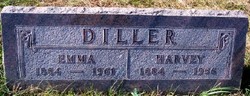
Emma Mary Smith Diller
| Birth | : | 12 Nov 1884 Zwingle, Dubuque County, Iowa, USA |
| Death | : | 9 Oct 1961 Washta, Cherokee County, Iowa, USA |
| Burial | : | Birkenhead-Glenfield Cemetery, Birkenhead, Auckland Council, New Zealand |
| Coordinate | : | -36.7989000, 174.7234700 |
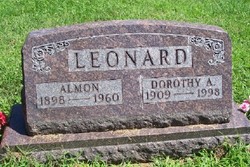
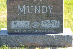
| Description | : | The Correctionville News, 12 October 1961, page 1: Mrs. Emma Diller, 76, resident of Grand Meadow Twp., Cherokee County for sixty years, died Monday, October 9, 1961, at her farm home. She is survived by a son, Ray Diller of Washta, two daughters, Mrs. Dorothy Leonard of Pierson and Mrs. Doris Mundy of Quimby, three grandchildren, two great grandchildren, a sister, Mrs. Anna Spencer of Pierson, and brothers Harry Smith of Sutherland and Raymond Smith of Manson. She was preceded by her husband Harvey November 11, 1956. Services will be held Thursday, October 12, at 2... Read More |
frequently asked questions (FAQ):
-
Where is Emma Mary Smith Diller's memorial?
Emma Mary Smith Diller's memorial is located at: Birkenhead-Glenfield Cemetery, Birkenhead, Auckland Council, New Zealand.
-
When did Emma Mary Smith Diller death?
Emma Mary Smith Diller death on 9 Oct 1961 in Washta, Cherokee County, Iowa, USA
-
Where are the coordinates of the Emma Mary Smith Diller's memorial?
Latitude: -36.7989000
Longitude: 174.7234700
Family Members:
Parent

Spouse

Siblings


Children
Flowers:


Nearby Cemetories:
1. Birkenhead-Glenfield Cemetery
Birkenhead, Auckland Council, New Zealand
Coordinate: -36.7989000, 174.7234700
2. Pompallier Cemetery
Birkenhead, Auckland Council, New Zealand
Coordinate: -36.8036900, 174.7251200
3. O'Neill's Point Cemetery
Belmont, Auckland Council, New Zealand
Coordinate: -36.8103002, 174.7812784
4. North Shore Memorial Park
Auckland, Auckland Council, New Zealand
Coordinate: -36.7545800, 174.6838900
5. Hobsonville Church and Settlers' Cemetery
Hobsonville, Auckland Council, New Zealand
Coordinate: -36.8000500, 174.6551800
6. Holy Trinity Cemetery
Silverdale, Auckland Council, New Zealand
Coordinate: -36.7429008, 174.6940822
7. Royal New Zealand Navy Memorial
Devonport, Auckland Council, New Zealand
Coordinate: -36.8305900, 174.7898900
8. Mount Victoria Cemetery
Devonport, Auckland Council, New Zealand
Coordinate: -36.8252490, 174.7978140
9. Symonds Street Cemetery
Auckland, Auckland Council, New Zealand
Coordinate: -36.8582828, 174.7636628
10. Albany Village Cemetery
Albany, Auckland Council, New Zealand
Coordinate: -36.7298900, 174.6972700
11. St. Stephen's Churchyard
Auckland, Auckland Council, New Zealand
Coordinate: -36.8504860, 174.7899970
12. Mount Eden Stockade Cemetery
Mount Eden, Auckland Council, New Zealand
Coordinate: -36.8678370, 174.7666430
13. St. Luke's Anglican Church Cemetery
Mount Albert, Auckland Council, New Zealand
Coordinate: -36.8785540, 174.7290400
14. St Mark's Anglican Church Cemetery
Remuera, Auckland Council, New Zealand
Coordinate: -36.8729300, 174.7801600
15. Savage Memorial
Auckland, Auckland Council, New Zealand
Coordinate: -36.8462500, 174.8259300
16. George Maxwell Memorial Cemetery
Avondale, Auckland Council, New Zealand
Coordinate: -36.8890320, 174.6849320
17. Ōrākei (Rautara St) Urupā
Orakei, Auckland Council, New Zealand
Coordinate: -36.8610770, 174.8188960
18. Saint Andrew's Churchyard
Epsom, Auckland Council, New Zealand
Coordinate: -36.8937200, 174.7654100
19. Saint Ninians Churchyard
Avondale, Auckland Council, New Zealand
Coordinate: -36.8994510, 174.6966690
20. St. Mary's Pioneer Cemetery
Torbay, Auckland Council, New Zealand
Coordinate: -36.6959500, 174.7512400
21. Purewa Cemetery
Meadowbank, Auckland Council, New Zealand
Coordinate: -36.8674300, 174.8297900
22. Auckland Provincial Memorial
Glen Eden, Auckland Council, New Zealand
Coordinate: -36.9020700, 174.6548500
23. Waikumete Cemetery & Crematorium
Glen Eden, Auckland Council, New Zealand
Coordinate: -36.9025130, 174.6539610
24. St. Thomas Churchyard
Tamaki, Auckland Council, New Zealand
Coordinate: -36.8675590, 174.8460560