

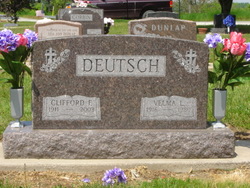
Etta Pauline Judd Dimmick-Fisher
| Birth | : | 25 Sep 1918 |
| Death | : | 3 Aug 2020 |
| Burial | : | Howland Cemetery, Conway, Franklin County, USA |
| Coordinate | : | 42.5127983, -72.6967010 |
| Plot | : | D-10-10-2 |
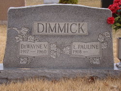
| Inscription | : | w/o DeWayne |
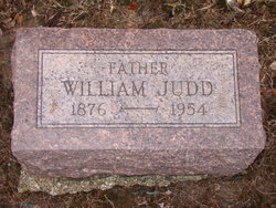
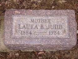
| Description | : | Etta Pauline Fisher, 101, of Columbia City, passed away Monday, August 3, 2020 at Miller's at Oak Pointe. Born September 25, 1918 in Whitley County, she was the daughter of William and Laura Bell (Egolf) Judd. She graduated from Coesse High School with the Class of 1936. After the passing of her first husband, DeWayne Vail Dimmick, she married Orval Fisher on July 11, 1971. Pauline and Orval were past owners of Columbia City Happy Valley Skating Rink. She also had been a farm housewife, worked at Blue Bell and did nursing. She was a member of Columbia City... Read More |
frequently asked questions (FAQ):
-
Where is Etta Pauline Judd Dimmick-Fisher's memorial?
Etta Pauline Judd Dimmick-Fisher's memorial is located at: Howland Cemetery, Conway, Franklin County, USA.
-
When did Etta Pauline Judd Dimmick-Fisher death?
Etta Pauline Judd Dimmick-Fisher death on 3 Aug 2020 in
-
Where are the coordinates of the Etta Pauline Judd Dimmick-Fisher's memorial?
Latitude: 42.5127983
Longitude: -72.6967010
Family Members:
Parent
Spouse
Siblings
Flowers:


Nearby Cemetories:
1. Howland Cemetery
Conway, Franklin County, USA
Coordinate: 42.5127983, -72.6967010
2. Pine Grove Cemetery
Conway, Franklin County, USA
Coordinate: 42.5222015, -72.6908035
3. South Centre Cemetery
Conway, Franklin County, USA
Coordinate: 42.5015940, -72.6973490
4. Maynard Cemetery
Conway, Franklin County, USA
Coordinate: 42.4836630, -72.7195800
5. Cricket Hill Cemetery
Conway, Franklin County, USA
Coordinate: 42.4783300, -72.7009500
6. Boyden Cemetery
Conway, Franklin County, USA
Coordinate: 42.4832993, -72.6667023
7. Mill River Cemetery
Deerfield, Franklin County, USA
Coordinate: 42.5011890, -72.6377770
8. Cosby Family Cemetery
Shelburne, Franklin County, USA
Coordinate: 42.5566400, -72.6702100
9. Hawks Cemetery
Deerfield, Franklin County, USA
Coordinate: 42.5555992, -72.6583023
10. South Part Cemetery
Conway, Franklin County, USA
Coordinate: 42.4625015, -72.6707993
11. Beldingville Cemetery
Ashfield, Franklin County, USA
Coordinate: 42.5365562, -72.7638016
12. South Ashfield Cemetery
Ashfield, Franklin County, USA
Coordinate: 42.5077209, -72.7730026
13. Savage Farm Cemetery
Deerfield, Franklin County, USA
Coordinate: 42.5336700, -72.6245300
14. North Shirkshire Cemetery
Conway, Franklin County, USA
Coordinate: 42.5689011, -72.7210999
15. Southwest Cemetery
Conway, Franklin County, USA
Coordinate: 42.4660280, -72.7458610
16. Baptist Corner Cemetery
Ashfield, Franklin County, USA
Coordinate: 42.5540771, -72.7639313
17. Baptist Cemetery
Deerfield, Franklin County, USA
Coordinate: 42.5555992, -72.6258011
18. Saint John's Church
Ashfield, Franklin County, USA
Coordinate: 42.5258600, -72.7894260
19. Plain Cemetery
Ashfield, Franklin County, USA
Coordinate: 42.5292015, -72.7889023
20. Shelburne Center Cemetery
Shelburne, Franklin County, USA
Coordinate: 42.5830000, -72.6969600
21. Old Deerfield Burying Ground
Deerfield, Franklin County, USA
Coordinate: 42.5449982, -72.6097031
22. South Cemetery
Shelburne, Franklin County, USA
Coordinate: 42.5819016, -72.6699982
23. Briar Hill Cemetery
Ashfield, Franklin County, USA
Coordinate: 42.4742600, -72.7798300
24. North Cemetery
Deerfield, Franklin County, USA
Coordinate: 42.5635100, -72.6249200