

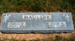
Eunice May Stearns Maulsby
| Birth | : | 26 Jan 1914 Waterloo, Black Hawk County, Iowa, USA |
| Death | : | 16 Sep 1996 Marshalltown, Marshall County, Iowa, USA |
| Burial | : | Parndon Wood Crematorium and Cemetery, Harlow, Harlow District, England |
| Coordinate | : | 51.7430160, 0.0898420 |
| Description | : | She died at a daughter's home in Marshalltown, Iowa. She graduated from Plover High School in 1933 and in 1935 she married Clyde Maulsby at Fairmont, Minn. The couple lived in Pocahontas for several years before settling in Plover. She worked as a postal clerk for many years in Plover until retiring in the early 1970's. He died in 1977. Survivors include daughters, Darla Johnson, Marshalltown, and Beth Gross, Greenville, S.C.; four grandchildren; 3 g-grandchildren; sisters, Florence Dickinson, Coon Rapids, Minn., June Hotovec, Albuquerque, N.M., Betty Sease, Des Moines, Connie Kraft, Goldfield, Rachel Freeman, Des Moines, Joy Sorensen, Goldfield,... Read More |
frequently asked questions (FAQ):
-
Where is Eunice May Stearns Maulsby's memorial?
Eunice May Stearns Maulsby's memorial is located at: Parndon Wood Crematorium and Cemetery, Harlow, Harlow District, England.
-
When did Eunice May Stearns Maulsby death?
Eunice May Stearns Maulsby death on 16 Sep 1996 in Marshalltown, Marshall County, Iowa, USA
-
Where are the coordinates of the Eunice May Stearns Maulsby's memorial?
Latitude: 51.7430160
Longitude: 0.0898420
Family Members:
Parent
Spouse
Siblings

Children
Flowers:


Nearby Cemetories:
1. Parndon Wood Crematorium and Cemetery
Harlow, Harlow District, England
Coordinate: 51.7430160, 0.0898420
2. St Mary the Virgin Churchyard
Great Parndon, Harlow District, England
Coordinate: 51.7605100, 0.0739860
3. All Saints Churchyard
Epping Upland, Epping Forest District, England
Coordinate: 51.7207440, 0.0888980
4. St Andrew Churchyard
Netteswell, Harlow District, England
Coordinate: 51.7640460, 0.1085500
5. All Saints Churchyard
Nazeing, Epping Forest District, England
Coordinate: 51.7436140, 0.0464100
6. St. Mary Magdalene Churchyard
Potter Street, Harlow District, England
Coordinate: 51.7558200, 0.1315900
7. Potter Street Baptist Churchyard
Harlow, Harlow District, England
Coordinate: 51.7575040, 0.1326510
8. St. Mary's Churchyard
Little Parndon, Harlow District, England
Coordinate: 51.7792683, 0.0840760
9. Roydon United Reform Churchyard
Roydon, Epping Forest District, England
Coordinate: 51.7714050, 0.0460240
10. St Mary-at-Latton Churchyard
Latton, Harlow District, England
Coordinate: 51.7774500, 0.1206750
11. St Botolph Church
Eastwick, East Hertfordshire District, England
Coordinate: 51.7851000, 0.0776000
12. Epping Cemetery
Epping, Epping Forest District, England
Coordinate: 51.6978250, 0.0974260
13. Harlow Baptist Burial Ground
Harlow, Harlow District, England
Coordinate: 51.7619700, 0.1584330
14. North Weald Bassett Cemetery
North Weald Bassett, Epping Forest District, England
Coordinate: 51.7254250, 0.1622850
15. St. Andrew's Churchyard
North Weald Bassett, Epping Forest District, England
Coordinate: 51.7254630, 0.1638090
16. St Alban the Martyr Churchyard
Coopersale, Epping Forest District, England
Coordinate: 51.7020000, 0.1338200
17. St Mary and St Hugh Churchyard
Old Harlow, Harlow District, England
Coordinate: 51.7822500, 0.1486600
18. St James' Churchyard
Stanstead Abbotts, East Hertfordshire District, England
Coordinate: 51.7806920, 0.0275950
19. St. Dunstan Churchyard
Hunsdon, East Hertfordshire District, England
Coordinate: 51.7951000, 0.0548190
20. St Mary's Churchyard
Gilston, East Hertfordshire District, England
Coordinate: 51.8016340, 0.0855550
21. St. Thomas Churchyard
Upshire, Epping Forest District, England
Coordinate: 51.6898890, 0.0465860
22. Saint Augustine's Churchyard
Broxbourne, Broxbourne Borough, England
Coordinate: 51.7445150, -0.0147810
23. St Catherine and St Paul's Churchyard
Hoddesdon, Broxbourne Borough, England
Coordinate: 51.7625830, -0.0120670
24. Saint James the Great Churchyard
Sawbridgeworth, East Hertfordshire District, England
Coordinate: 51.8066600, 0.1213100