
| Birth | : | 10 Nov 1924 Monona County, Iowa, USA |
| Death | : | 14 May 2014 Council Bluffs, Pottawattamie County, Iowa, USA |
| Burial | : | Memorial Park Cemetery, Council Bluffs, Pottawattamie County, USA |
| Coordinate | : | 41.2644005, -95.8261032 |
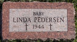
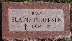
| Description | : | Evelyn G. Orr The Daily Nonpareil - Council Bluffs, Iowa May 17, 2014 Evelyn G. Orr, age 89, passed away suddenly on May 14, 2014. Evelyn was born November 10, 1924, on the family farm in Monona County to John and Mary (Goetz) Mahlberg. Evelyn worked at the Peoples Store, Mercy Hospital, as their baker and Rog & Scotty's Super Market. Evelyn is a member of St. Patrick's Church. She is preceded in death by her parents, infant daughters, Linda and Elaine; and husband, Gilbert Orr who passed away two weeks ago, April 30, 2014. |
frequently asked questions (FAQ):
-
Where is Evelyn G Mahlberg Orr's memorial?
Evelyn G Mahlberg Orr's memorial is located at: Memorial Park Cemetery, Council Bluffs, Pottawattamie County, USA.
-
When did Evelyn G Mahlberg Orr death?
Evelyn G Mahlberg Orr death on 14 May 2014 in Council Bluffs, Pottawattamie County, Iowa, USA
-
Where are the coordinates of the Evelyn G Mahlberg Orr's memorial?
Latitude: 41.2644005
Longitude: -95.8261032
Family Members:
Parent
Spouse

Siblings
Children
Flowers:


Nearby Cemetories:
1. Memorial Park Cemetery
Council Bluffs, Pottawattamie County, USA
Coordinate: 41.2644005, -95.8261032
2. Ridgewood Cemetery
Council Bluffs, Pottawattamie County, USA
Coordinate: 41.2694016, -95.8272018
3. Oak Hill Cemetery
Council Bluffs, Pottawattamie County, USA
Coordinate: 41.2700900, -95.8226400
4. Bikhor Cholim Cemetery
Council Bluffs, Pottawattamie County, USA
Coordinate: 41.2703670, -95.8229350
5. Walnut Hill Cemetery
Council Bluffs, Pottawattamie County, USA
Coordinate: 41.2719002, -95.8255997
6. Cedar Lawn Cemetery
Council Bluffs, Pottawattamie County, USA
Coordinate: 41.2694016, -95.8182983
7. Saint Joseph Cemetery
Council Bluffs, Pottawattamie County, USA
Coordinate: 41.2722015, -95.8208008
8. Clark Cemetery
Pottawattamie County, USA
Coordinate: 41.2551610, -95.8223390
9. Green Valley Cemetery
Council Bluffs, Pottawattamie County, USA
Coordinate: 41.2743988, -95.8225021
10. Fairview Cemetery
Council Bluffs, Pottawattamie County, USA
Coordinate: 41.2703018, -95.8480988
11. Garner Cemetery
Council Bluffs, Pottawattamie County, USA
Coordinate: 41.2956161, -95.8001709
12. Maple Grove Cemetery
Council Bluffs, Pottawattamie County, USA
Coordinate: 41.2265560, -95.8187100
13. Stoker-Graybill Cemetery
Council Bluffs, Pottawattamie County, USA
Coordinate: 41.2532620, -95.7751770
14. Lewis Township Cemetery
Council Bluffs, Pottawattamie County, USA
Coordinate: 41.2117004, -95.7938995
15. Evans Cemetery
Crescent, Pottawattamie County, USA
Coordinate: 41.3255997, -95.8368988
16. Council Point Cemetery
Council Bluffs, Pottawattamie County, USA
Coordinate: 41.2110830, -95.8788610
17. Gregg Cemetery
Weston, Pottawattamie County, USA
Coordinate: 41.3330000, -95.7931000
18. Trinity Cathedral Columbarium
Omaha, Douglas County, USA
Coordinate: 41.2603900, -95.9393660
19. Hazel Dell Cemetery
Council Bluffs, Pottawattamie County, USA
Coordinate: 41.3489723, -95.7939911
20. Saint Columbanus Cemetery
Weston, Pottawattamie County, USA
Coordinate: 41.3429440, -95.7435260
21. Prospect Hill Cemetery
Omaha, Douglas County, USA
Coordinate: 41.2780991, -95.9593964
22. Crescent Cemetery
Crescent, Pottawattamie County, USA
Coordinate: 41.3664894, -95.8566208
23. First Central Congregational Columbarium
Omaha, Douglas County, USA
Coordinate: 41.2563456, -95.9658365
24. Saint Pauls Evangelical Country Church Cemetery
Dumfries, Pottawattamie County, USA
Coordinate: 41.1748352, -95.7492371