
| Birth | : | 18 Aug 1862 Rossville, Allamakee County, Iowa, USA |
| Death | : | 16 Sep 1942 Bellwood, Butler County, Nebraska, USA |
| Burial | : | Spalding Cemetery, Spalding, South Holland District, England |
| Coordinate | : | 52.7954960, -0.1519390 |
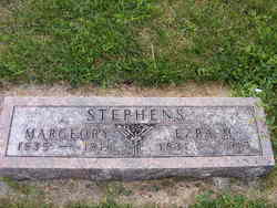
| Description | : | His gravestone mistakenly gives his birth date as 1860. `````````````` Butler County Press (David City, Nebr.), September 24, 1942, p. 1, col. 3 A LONG TIME RESIDENT DIED WEDNESDAY, SEPT. 16 Funeral of Ezra Parker Stephens Held Friday Afternoon Ezra Parker Stephens, long-time resident of Butler county, died at 10:35 a.m. Wednesday, Sept. 16, at his home eight miles south of Columbus, from complications after illness of eight months. He was 80 years of age. Funeral services were conducted at the Stephens home at 2 o'clock Friday afternoon by a Jehovah speaker from Columbus. The pallbearers were George Cady, Wolford Hiatt, John Minnick, Roy McKnight, Ben Snyder... Read More |
frequently asked questions (FAQ):
-
Where is Ezra Parker Stephens's memorial?
Ezra Parker Stephens's memorial is located at: Spalding Cemetery, Spalding, South Holland District, England.
-
When did Ezra Parker Stephens death?
Ezra Parker Stephens death on 16 Sep 1942 in Bellwood, Butler County, Nebraska, USA
-
Where are the coordinates of the Ezra Parker Stephens's memorial?
Latitude: 52.7954960
Longitude: -0.1519390
Family Members:
Parent

Spouse

Siblings
Children


Nearby Cemetories:
1. Spalding Cemetery
Spalding, South Holland District, England
Coordinate: 52.7954960, -0.1519390
2. St Paul's Churchyard
Spalding, South Holland District, England
Coordinate: 52.7969559, -0.1305557
3. St. Mary's Churchyard
Pinchbeck, South Holland District, England
Coordinate: 52.8135340, -0.1589220
4. St. Laurence Churchyard
Surfleet, South Holland District, England
Coordinate: 52.8369500, -0.1436110
5. St Bartholomew's Church West Pinchbeck
Pinchbeck, South Holland District, England
Coordinate: 52.8080873, -0.2216285
6. Surfleet Cemetery
Surfleet, South Holland District, England
Coordinate: 52.8391670, -0.1383330
7. St. Mary's Cemetery
Weston, South Holland District, England
Coordinate: 52.8078662, -0.0809039
8. South Lincolnshire Crematorium
Surfleet, South Holland District, England
Coordinate: 52.8451100, -0.1475110
9. All Saints Churchyard
Moulton, South Holland District, England
Coordinate: 52.7990056, -0.0629691
10. Moulton Cemetery
Moulton, South Holland District, England
Coordinate: 52.8017000, -0.0632400
11. St Gilbert and St Hugh Churchyard
Gosberton Clough, South Holland District, England
Coordinate: 52.8518081, -0.2166268
12. St. Mary's Churchyard
Whaplode, South Holland District, England
Coordinate: 52.7974840, -0.0385520
13. Gosberton Baptist Church
Gosberton, South Holland District, England
Coordinate: 52.8651820, -0.1533940
14. Gosberton Cemetery
Gosberton, South Holland District, England
Coordinate: 52.8659400, -0.1623000
15. St. Peter and St. Paul Churchyard
Gosberton, South Holland District, England
Coordinate: 52.8690870, -0.1629740
16. Whaplode Cemetery
Whaplode, South Holland District, England
Coordinate: 52.8016190, -0.0281347
17. St. Margaret's Churchyard
Quadring, South Holland District, England
Coordinate: 52.8903400, -0.1819700
18. All Saints Churchyard
Holbeach, South Holland District, England
Coordinate: 52.8036140, 0.0142530
19. Holbeach Cemetery
Holbeach, South Holland District, England
Coordinate: 52.8062100, 0.0171500
20. St. John's Churchyard
Holbeach, South Holland District, England
Coordinate: 52.7457510, -0.0024000
21. All Saints Churchyard
Fosdyke, Boston Borough, England
Coordinate: 52.8811100, -0.0469440
22. Fosdyke Village Cemetery
Fosdyke, Boston Borough, England
Coordinate: 52.8808330, -0.0447220
23. Sutterton Village Cemetery
Sutterton, Boston Borough, England
Coordinate: 52.8994440, -0.0900000
24. St. John the Baptist Churchyard
Whaplode Drove, South Holland District, England
Coordinate: 52.7034435, -0.0476688