
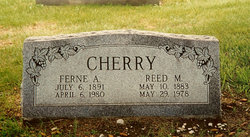
Ferne Arlene Corbin Cherry
| Birth | : | 6 Jul 1891 Craig, Burt County, Nebraska, USA |
| Death | : | 6 Apr 1980 Oakland, Burt County, Nebraska, USA |
| Burial | : | Low Row Methodist Cemetery, Low Row, Richmondshire District, England |
| Coordinate | : | 54.3798050, -2.0259320 |
| Description | : | From the April 10, 1980 issue of the "Burt County Plaindealer": "Cherry rites held Wednesday Funeral services were held Wednesday, April 9, at the United PresbyterianChurch in Craig for Mrs. Reed Cherry, 88. Mrs. Cherry died April 6 at Oakland. Pastor Melva Tranmer officiated the rites. Music was provided by Mrs. Howard Lund, organist. Pallbearers were Jim Kennedy, Theo Eriksen, Jr., Robert Wolfe, Roger Johnson, Ernest Geary and Raymond Holm. Ferne Arlene Corbin Cherry was born at Craig on July 6, 1891, to Alex and Suie P. Corbin. She was married to Reed Cherry... Read More |
frequently asked questions (FAQ):
-
Where is Ferne Arlene Corbin Cherry's memorial?
Ferne Arlene Corbin Cherry's memorial is located at: Low Row Methodist Cemetery, Low Row, Richmondshire District, England.
-
When did Ferne Arlene Corbin Cherry death?
Ferne Arlene Corbin Cherry death on 6 Apr 1980 in Oakland, Burt County, Nebraska, USA
-
Where are the coordinates of the Ferne Arlene Corbin Cherry's memorial?
Latitude: 54.3798050
Longitude: -2.0259320
Family Members:
Parent

Spouse

Children

Flowers:


Nearby Cemetories:
1. Low Row Methodist Cemetery
Low Row, Richmondshire District, England
Coordinate: 54.3798050, -2.0259320
2. Holy Trinity Churchyard
Low Row, Richmondshire District, England
Coordinate: 54.3812800, -2.0223090
3. Low Row United Reformed Chapelyard
Low Row, Richmondshire District, England
Coordinate: 54.3755880, -2.0317420
4. Gunnerside Wesleyan Methodist Chapelyard
Gunnerside, Richmondshire District, England
Coordinate: 54.3783950, -2.0778320
5. Langthwaite Wesleyan Methodist Chapelyard
Langthwaite, Richmondshire District, England
Coordinate: 54.4181000, -1.9958500
6. St. Mary the Virgin Churchyard
Langthwaite, Richmondshire District, England
Coordinate: 54.4195260, -1.9967580
7. Church of Saint Mary the Virgin Graveyard
Arkengarthdale, Richmondshire District, England
Coordinate: 54.4225063, -2.0013365
8. Reeth Congregational Chapelyard
Reeth, Richmondshire District, England
Coordinate: 54.3878600, -1.9422700
9. St. Andrew's Churchyard
Grinton, Richmondshire District, England
Coordinate: 54.3812610, -1.9305740
10. Reeth and Grinton Cemetery
Grinton, Richmondshire District, England
Coordinate: 54.3800400, -1.9246700
11. St. Mary's Churchyard
Muker, Richmondshire District, England
Coordinate: 54.3763690, -2.1392860
12. St. Oswald Churchyard
Askrigg, Richmondshire District, England
Coordinate: 54.3147100, -2.0817500
13. Marrick Priory Churchyard
Marrick, Richmondshire District, England
Coordinate: 54.3758830, -1.8977990
14. Askrigg Cemetery
Askrigg, Richmondshire District, England
Coordinate: 54.3141230, -2.0915060
15. Friends Meeting House Burial Ground
Carperby, Richmondshire District, England
Coordinate: 54.3031720, -1.9925670
16. Friends Burial Ground
Bainbridge, Richmondshire District, England
Coordinate: 54.3093330, -2.1023380
17. Keld United Reform Chapelyard
Keld, Richmondshire District, England
Coordinate: 54.4055920, -2.1660210
18. Bainbridge Cemetery
Bainbridge, Richmondshire District, England
Coordinate: 54.3054000, -2.0994100
19. St Mary Churchyard
Redmire, Richmondshire District, England
Coordinate: 54.3126200, -1.9227400
20. St. Andrew Churchyard
Aysgarth, Richmondshire District, England
Coordinate: 54.2922340, -1.9833760
21. Preston Under Scar Cemetery
Preston-under-Scar, Richmondshire District, England
Coordinate: 54.3133800, -1.8964000
22. St Edmund the Martyr Churchyard
Marske, Richmondshire District, England
Coordinate: 54.3997500, -1.8403700
23. St Bartholomew Churchyard
West Witton, Richmondshire District, England
Coordinate: 54.2920100, -1.9073200
24. St Michael and All Angels Churchyard
Downholme, Richmondshire District, England
Coordinate: 54.3799700, -1.8313400