
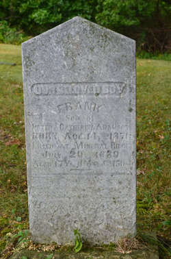
Frank Adamson
| Birth | : | 14 Aug 1871 Hardin Township, Webster County, Iowa, USA |
| Death | : | 29 Jul 1889 Ridgeport, Boone County, Iowa, USA |
| Burial | : | Blessed Virgin Mary Churchyard, Huish Episcopi, South Somerset District, England |
| Coordinate | : | 51.0362250, -2.8182410 |
| Description | : | Gowrie News August 1, 1889 About 12 o'clock on the night of July 29th at Ridgeport, a small town eight miles north of Boone, John A. Peterson, deputy postmaster, was awakened by some one trying to get into the store and post office. He saw a man reaching in a window that had been broken. Peterson fired and the burglar dropped dead on the outside, shot through the head. An accomplice who was with him escaped. In the morning it was discovered that the dead man was Frank Adamson, aged about twenty, son of a farmer living near Mineral... Read More |
frequently asked questions (FAQ):
-
Where is Frank Adamson's memorial?
Frank Adamson's memorial is located at: Blessed Virgin Mary Churchyard, Huish Episcopi, South Somerset District, England.
-
When did Frank Adamson death?
Frank Adamson death on 29 Jul 1889 in Ridgeport, Boone County, Iowa, USA
-
Where are the coordinates of the Frank Adamson's memorial?
Latitude: 51.0362250
Longitude: -2.8182410
Family Members:
Parent

Siblings
Flowers:


Nearby Cemetories:
1. Blessed Virgin Mary Churchyard
Huish Episcopi, South Somerset District, England
Coordinate: 51.0362250, -2.8182410
2. All Saints Churchyard
Langport, South Somerset District, England
Coordinate: 51.0369970, -2.8254530
3. Langport Cemetery
Langport, South Somerset District, England
Coordinate: 51.0426200, -2.8244600
4. St. Peter and St. Paul's Churchyard
Muchelney, South Somerset District, England
Coordinate: 51.0207389, -2.8154595
5. Low Ham Church in the Field
High Ham, South Somerset District, England
Coordinate: 51.0583449, -2.8155268
6. St John the Baptist Churchyard
Pitney, South Somerset District, England
Coordinate: 51.0532200, -2.7937320
7. St. Catherine's Churchyard
Drayton, South Somerset District, England
Coordinate: 51.0191860, -2.8494960
8. Curry Rivel Cemetery
Curry Rivel, South Somerset District, England
Coordinate: 51.0257667, -2.8676226
9. St. Andrew's Churchyard
Curry Rivel, South Somerset District, England
Coordinate: 51.0246570, -2.8687410
10. Saint Andrew's Churchyard
Aller, South Somerset District, England
Coordinate: 51.0554000, -2.8627000
11. Long Sutton Friends Burial Ground
Long Sutton, South Somerset District, England
Coordinate: 51.0302700, -2.7612300
12. High Ham Cemetery
High Ham, South Somerset District, England
Coordinate: 51.0739931, -2.8216351
13. Holy Trinity Churchyard
Long Sutton, South Somerset District, England
Coordinate: 51.0246110, -2.7577940
14. St. Andrew's Churchyard
High Ham, South Somerset District, England
Coordinate: 51.0760320, -2.8218400
15. Christ Church Cemetery
Long Load, South Somerset District, England
Coordinate: 51.0054700, -2.7639100
16. St. Martin's Churchyard
Kingsbury Episcopi, South Somerset District, England
Coordinate: 50.9863950, -2.8043130
17. St. Catherine's Churchyard
Fivehead, South Somerset District, England
Coordinate: 51.0083009, -2.9000973
18. St. James the Less Churchyard
Hambridge, South Somerset District, England
Coordinate: 50.9849380, -2.8669180
19. Othery Cemetery
Othery, Sedgemoor District, England
Coordinate: 51.0771222, -2.8906189
20. Ash Parish Cemetery
Ash, South Somerset District, England
Coordinate: 50.9833540, -2.7538380
21. Holy Trinity Churchyard
Ash, South Somerset District, England
Coordinate: 50.9834250, -2.7528400
22. St Michael Churchyard
Burrowbridge, Taunton Deane Borough, England
Coordinate: 51.0698090, -2.9174960
23. Saint Andrew Churchyard
Compton Dundon, South Somerset District, England
Coordinate: 51.0897330, -2.7442800
24. Stoke St Gregory
Stoke St Gregory, Taunton Deane Borough, England
Coordinate: 51.0398130, -2.9310570