
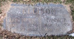
| Birth | : | unknown Woodbine, Harrison County, Iowa, USA |
| Death | : | Jul 1986 Council Bluffs, Pottawattamie County, Iowa, USA |
| Burial | : | Memorial Park Cemetery, Council Bluffs, Pottawattamie County, USA |
| Coordinate | : | 41.2644005, -95.8261032 |
| Description | : | obit: Council Bluffs, Iowa Nonpareil July 30, 1986 age 68 years, died at a local hospital; 60 year resident of Council Bluffs; retired as a locomotive engineer after 37 years Union Pacific Railroad; member Queen of Apostles Church; Beem Belford Funeral Home in charge with Rev. Robert Hoefler officiating preceded in death by wife Gladys survived by wife Joyce; son Richard L. of Malvern; a daughter Shirley Leakey of Council Bluffs; stepdaughters Darcy McClelland of Pierre, SD and Mary Beckner and Harriett Smith both of CB; stepsons Jeff and Dan Beckner of CB; Robert and Charles Milledge... Read More |
frequently asked questions (FAQ):
-
Where is Franklin L. Ellison's memorial?
Franklin L. Ellison's memorial is located at: Memorial Park Cemetery, Council Bluffs, Pottawattamie County, USA.
-
When did Franklin L. Ellison death?
Franklin L. Ellison death on Jul 1986 in Council Bluffs, Pottawattamie County, Iowa, USA
-
Where are the coordinates of the Franklin L. Ellison's memorial?
Latitude: 41.2644005
Longitude: -95.8261032
Family Members:
Parent

Spouse

Siblings
Children
Flowers:


Nearby Cemetories:
1. Memorial Park Cemetery
Council Bluffs, Pottawattamie County, USA
Coordinate: 41.2644005, -95.8261032
2. Ridgewood Cemetery
Council Bluffs, Pottawattamie County, USA
Coordinate: 41.2694016, -95.8272018
3. Oak Hill Cemetery
Council Bluffs, Pottawattamie County, USA
Coordinate: 41.2700900, -95.8226400
4. Bikhor Cholim Cemetery
Council Bluffs, Pottawattamie County, USA
Coordinate: 41.2703670, -95.8229350
5. Walnut Hill Cemetery
Council Bluffs, Pottawattamie County, USA
Coordinate: 41.2719002, -95.8255997
6. Cedar Lawn Cemetery
Council Bluffs, Pottawattamie County, USA
Coordinate: 41.2694016, -95.8182983
7. Saint Joseph Cemetery
Council Bluffs, Pottawattamie County, USA
Coordinate: 41.2722015, -95.8208008
8. Clark Cemetery
Pottawattamie County, USA
Coordinate: 41.2551610, -95.8223390
9. Green Valley Cemetery
Council Bluffs, Pottawattamie County, USA
Coordinate: 41.2743988, -95.8225021
10. Fairview Cemetery
Council Bluffs, Pottawattamie County, USA
Coordinate: 41.2703018, -95.8480988
11. Garner Cemetery
Council Bluffs, Pottawattamie County, USA
Coordinate: 41.2956161, -95.8001709
12. Maple Grove Cemetery
Council Bluffs, Pottawattamie County, USA
Coordinate: 41.2265560, -95.8187100
13. Stoker-Graybill Cemetery
Council Bluffs, Pottawattamie County, USA
Coordinate: 41.2532620, -95.7751770
14. Lewis Township Cemetery
Council Bluffs, Pottawattamie County, USA
Coordinate: 41.2117004, -95.7938995
15. Evans Cemetery
Crescent, Pottawattamie County, USA
Coordinate: 41.3255997, -95.8368988
16. Council Point Cemetery
Council Bluffs, Pottawattamie County, USA
Coordinate: 41.2110830, -95.8788610
17. Gregg Cemetery
Weston, Pottawattamie County, USA
Coordinate: 41.3330000, -95.7931000
18. Trinity Cathedral Columbarium
Omaha, Douglas County, USA
Coordinate: 41.2603900, -95.9393660
19. Hazel Dell Cemetery
Council Bluffs, Pottawattamie County, USA
Coordinate: 41.3489723, -95.7939911
20. Saint Columbanus Cemetery
Weston, Pottawattamie County, USA
Coordinate: 41.3429440, -95.7435260
21. Prospect Hill Cemetery
Omaha, Douglas County, USA
Coordinate: 41.2780991, -95.9593964
22. Crescent Cemetery
Crescent, Pottawattamie County, USA
Coordinate: 41.3664894, -95.8566208
23. First Central Congregational Columbarium
Omaha, Douglas County, USA
Coordinate: 41.2563456, -95.9658365
24. Saint Pauls Evangelical Country Church Cemetery
Dumfries, Pottawattamie County, USA
Coordinate: 41.1748352, -95.7492371