Gaylin “Bud” Monson
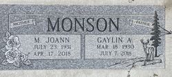
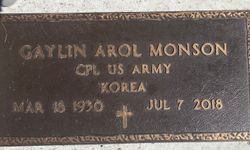
| Birth | : | 18 Mar 1930 Bottineau, Bottineau County, North Dakota, USA |
| Death | : | 7 Jul 2018 Tioga, Williams County, North Dakota, USA |
| Burial | : | Sunset Rest Cemetery, Ray, Williams County, USA |
| Coordinate | : | 48.3431015, -103.1905975 |
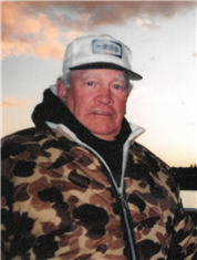
| Description | : | Gaylin “Bud” Monson, age 88, resident of Ray, ND, passed away quietly on Saturday, July 7, 2018 at The Tioga Hospital. Bud was born March 18, 1930, the son of Alfred and Adline (Ihla) Monson in Bottineau, ND. He and his 4 siblings were raised on the family farm north of Bottineau near Lake Metigoshi. He graduated from Bottineau High School and sometime after graduation, he joined the military and spent time overseas during the Korean War. In the 1950’s he moved to Ray to work at Westland Gas Station with an old friend, Jack Stewart. It was there, he met Joann... Read More |
frequently asked questions (FAQ):
-
Where is Gaylin “Bud” Monson's memorial?
Gaylin “Bud” Monson's memorial is located at: Sunset Rest Cemetery, Ray, Williams County, USA.
-
When did Gaylin “Bud” Monson death?
Gaylin “Bud” Monson death on 7 Jul 2018 in Tioga, Williams County, North Dakota, USA
-
Where are the coordinates of the Gaylin “Bud” Monson's memorial?
Latitude: 48.3431015
Longitude: -103.1905975
Family Members:
Parent
Spouse
Siblings
Flowers:
Nearby Cemetories:
1. Sunset Rest Cemetery
Ray, Williams County, USA
Coordinate: 48.3431015, -103.1905975
2. Soine Family Cemetery
Ray, Williams County, USA
Coordinate: 48.3349990, -103.1952670
3. Saint Michaels Cemetery
Ray, Williams County, USA
Coordinate: 48.3483009, -103.1781006
4. Dunkard Church Cemetery
Wheelock, Williams County, USA
Coordinate: 48.3431620, -103.2371250
5. Hilltop Cemetery
Wheelock, Williams County, USA
Coordinate: 48.2915560, -103.1414530
6. Wheelock Cemetery
Wheelock, Williams County, USA
Coordinate: 48.2874985, -103.2596970
7. Emmanual Lutheran German Cemetery
Ray, Williams County, USA
Coordinate: 48.3278008, -103.0580978
8. Temple Cemetery
Temple, Williams County, USA
Coordinate: 48.3871994, -103.0475006
9. Saint Mary Catholic Cemetery
Epping, Williams County, USA
Coordinate: 48.2671380, -103.3453700
10. Epping Cemetery
Epping, Williams County, USA
Coordinate: 48.2602997, -103.3550034
11. Rainbow Valley Lutheran Cemetery
Wildrose, Williams County, USA
Coordinate: 48.4802361, -103.2330551
12. Bethany Valley Cemetery
Epping, Williams County, USA
Coordinate: 48.4056015, -103.3842010
13. Trinity Lutheran Cemetery
Tioga, Williams County, USA
Coordinate: 48.2980800, -102.9476700
14. Minton Cemetery
Williams County, USA
Coordinate: 48.3867760, -102.9412060
15. Zion Lutheran Cemetery
Tioga, Williams County, USA
Coordinate: 48.3911018, -102.9411011
16. Betaini Lutheran Cemetery
Tioga, Williams County, USA
Coordinate: 48.2691994, -102.9558029
17. United Cemetery
Tioga, Williams County, USA
Coordinate: 48.3885994, -102.9396973
18. Eastside Cemetery
Tioga, Williams County, USA
Coordinate: 48.3939018, -102.9235992
19. Saint Paul Lutheran Cemetery
Wildrose, Williams County, USA
Coordinate: 48.5321999, -103.1857986
20. Bakken Cemetery
Tioga, Williams County, USA
Coordinate: 48.4160995, -102.9216995
21. Saint Olaf Cemetery
Temple, Williams County, USA
Coordinate: 48.5069008, -103.0160980
22. Beaver Creek Cemetery
Tioga, Williams County, USA
Coordinate: 48.1751900, -103.0217650
23. Springbrook Cemetery #2
Spring Brook, Williams County, USA
Coordinate: 48.2556839, -103.4734116
24. Barstad Cemetery
Tioga, Williams County, USA
Coordinate: 48.1746560, -102.9990800


