
| Birth | : | 29 Dec 1924 Council Bluffs, Pottawattamie County, Iowa, USA |
| Death | : | 10 Jul 2004 Council Bluffs, Pottawattamie County, Iowa, USA |
| Burial | : | Saint Joseph Cemetery, Council Bluffs, Pottawattamie County, USA |
| Coordinate | : | 41.2722015, -95.8208008 |
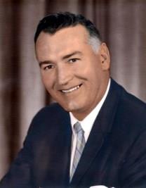
| Description | : | = Daily Nonpareil 07/11/2004 Gene M. Ronk Gene M. Ronk, 79, of Council Bluffs died July 10 in Council Bluffs. He was born Dec. 29, 1924, in Council Bluffs to Paul and Frances Hughes Ronk. He was a warehouse foreman for McKesson Robbins for 45 years. He was also a member of St. Patrick's Church, the Knights of Columbus and the American Legion Post No. 2. He was a former bartender on Saturday nights at The Alibi and Office bar. Mr. Ronk and his wife, Bernice (Goeser) were married 56 years. He was preceded in death by his parents and by a daughter, Jeanie. Survivors in... Read More |
frequently asked questions (FAQ):
-
Where is Gene Monroe Ronk's memorial?
Gene Monroe Ronk's memorial is located at: Saint Joseph Cemetery, Council Bluffs, Pottawattamie County, USA.
-
When did Gene Monroe Ronk death?
Gene Monroe Ronk death on 10 Jul 2004 in Council Bluffs, Pottawattamie County, Iowa, USA
-
Where are the coordinates of the Gene Monroe Ronk's memorial?
Latitude: 41.2722015
Longitude: -95.8208008
Family Members:
Parent

Spouse
Siblings
Children
Flowers:


Nearby Cemetories:
1. Saint Joseph Cemetery
Council Bluffs, Pottawattamie County, USA
Coordinate: 41.2722015, -95.8208008
2. Bikhor Cholim Cemetery
Council Bluffs, Pottawattamie County, USA
Coordinate: 41.2703670, -95.8229350
3. Oak Hill Cemetery
Council Bluffs, Pottawattamie County, USA
Coordinate: 41.2700900, -95.8226400
4. Green Valley Cemetery
Council Bluffs, Pottawattamie County, USA
Coordinate: 41.2743988, -95.8225021
5. Cedar Lawn Cemetery
Council Bluffs, Pottawattamie County, USA
Coordinate: 41.2694016, -95.8182983
6. Walnut Hill Cemetery
Council Bluffs, Pottawattamie County, USA
Coordinate: 41.2719002, -95.8255997
7. Ridgewood Cemetery
Council Bluffs, Pottawattamie County, USA
Coordinate: 41.2694016, -95.8272018
8. Memorial Park Cemetery
Council Bluffs, Pottawattamie County, USA
Coordinate: 41.2644005, -95.8261032
9. Clark Cemetery
Pottawattamie County, USA
Coordinate: 41.2551610, -95.8223390
10. Fairview Cemetery
Council Bluffs, Pottawattamie County, USA
Coordinate: 41.2703018, -95.8480988
11. Garner Cemetery
Council Bluffs, Pottawattamie County, USA
Coordinate: 41.2956161, -95.8001709
12. Stoker-Graybill Cemetery
Council Bluffs, Pottawattamie County, USA
Coordinate: 41.2532620, -95.7751770
13. Maple Grove Cemetery
Council Bluffs, Pottawattamie County, USA
Coordinate: 41.2265560, -95.8187100
14. Evans Cemetery
Crescent, Pottawattamie County, USA
Coordinate: 41.3255997, -95.8368988
15. Lewis Township Cemetery
Council Bluffs, Pottawattamie County, USA
Coordinate: 41.2117004, -95.7938995
16. Gregg Cemetery
Weston, Pottawattamie County, USA
Coordinate: 41.3330000, -95.7931000
17. Council Point Cemetery
Council Bluffs, Pottawattamie County, USA
Coordinate: 41.2110830, -95.8788610
18. Hazel Dell Cemetery
Council Bluffs, Pottawattamie County, USA
Coordinate: 41.3489723, -95.7939911
19. Trinity Cathedral Columbarium
Omaha, Douglas County, USA
Coordinate: 41.2603900, -95.9393660
20. Saint Columbanus Cemetery
Weston, Pottawattamie County, USA
Coordinate: 41.3429440, -95.7435260
21. Crescent Cemetery
Crescent, Pottawattamie County, USA
Coordinate: 41.3664894, -95.8566208
22. Prospect Hill Cemetery
Omaha, Douglas County, USA
Coordinate: 41.2780991, -95.9593964
23. First Central Congregational Columbarium
Omaha, Douglas County, USA
Coordinate: 41.2563456, -95.9658365
24. Saint Pauls Evangelical Country Church Cemetery
Dumfries, Pottawattamie County, USA
Coordinate: 41.1748352, -95.7492371