
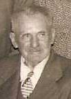

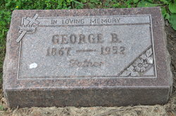
George Benjamin Olson
| Birth | : | 2 Jul 1867 Allamakee County, Iowa, USA |
| Death | : | 27 Apr 1952 Waukon, Allamakee County, Iowa, USA |
| Burial | : | Oak Grove Cemetery, Missouri Valley, Harrison County, USA |
| Coordinate | : | 41.5167007, -95.8649979 |
| Description | : | George B. Olson Dies on Sunday George B. Olson, Allamakee county pioneer, died Sunday, April 27, at the Waukon Memorial hospital, following a month's illness. He was a son of Mr. and Mrs. Peder Olson, early settlers in Center township, where he was born July 2, 1867, on the farm which had been his home for over sixty years. In his younger years he was known throughout the county as a veterinarian and stockman. As a young man he homesteaded and worked on the construction of railroads in Wyoming, western Nebraska and the Black Hills. His marriage to Inger Kaasa... Read More |
frequently asked questions (FAQ):
-
Where is George Benjamin Olson's memorial?
George Benjamin Olson's memorial is located at: Oak Grove Cemetery, Missouri Valley, Harrison County, USA.
-
When did George Benjamin Olson death?
George Benjamin Olson death on 27 Apr 1952 in Waukon, Allamakee County, Iowa, USA
-
Where are the coordinates of the George Benjamin Olson's memorial?
Latitude: 41.5167007
Longitude: -95.8649979
Family Members:
Parent

Spouse
Siblings
Children
Flowers:


Nearby Cemetories:
1. Oak Grove Cemetery
Missouri Valley, Harrison County, USA
Coordinate: 41.5167007, -95.8649979
2. Branson Cemetery
Loveland, Pottawattamie County, USA
Coordinate: 41.4846992, -95.8606033
3. Rose Hill Memorial Gardens
Missouri Valley, Harrison County, USA
Coordinate: 41.5656000, -95.8897000
4. Hurleys Evergreen Cemetery
Harrison County, USA
Coordinate: 41.5700989, -95.8618698
5. Mount Carmel Cemetery
Missouri Valley, Harrison County, USA
Coordinate: 41.5675011, -95.8897018
6. Saint Bridgets Cemetery
Honey Creek, Pottawattamie County, USA
Coordinate: 41.4664001, -95.8289032
7. Crook Cemetery
Honey Creek, Pottawattamie County, USA
Coordinate: 41.4581330, -95.8737000
8. Champan Frazier Cemetery
Harrison County, USA
Coordinate: 41.5773500, -95.8933500
9. Allen Cemetery
Pottawattamie County, USA
Coordinate: 41.4427986, -95.8550034
10. Frazier Cemetery
Missouri Valley, Harrison County, USA
Coordinate: 41.5932999, -95.8375015
11. Grange Cemetery
Honey Creek, Pottawattamie County, USA
Coordinate: 41.4446678, -95.8034668
12. Linnwood Cemetery
Harrison County, USA
Coordinate: 41.5589200, -95.7502100
13. Reels Cemetery
Crescent, Pottawattamie County, USA
Coordinate: 41.4234100, -95.8321700
14. William C McIntosh Cemetery
Crescent, Pottawattamie County, USA
Coordinate: 41.4088745, -95.8477097
15. Saint Pauls Lutheran Cemetery
Neola, Pottawattamie County, USA
Coordinate: 41.4337000, -95.7607000
16. Harris Grove Cemetery
Beebeetown, Harrison County, USA
Coordinate: 41.5782928, -95.7262192
17. Calhoun Cemetery
Calhoun, Harrison County, USA
Coordinate: 41.6391983, -95.8938980
18. Fort Calhoun Cemetery
Fort Calhoun, Washington County, USA
Coordinate: 41.4581375, -96.0352020
19. Logan Cemetery
Logan, Harrison County, USA
Coordinate: 41.6487579, -95.7843170
20. Crescent Cemetery
Crescent, Pottawattamie County, USA
Coordinate: 41.3664894, -95.8566208
21. Shipley Cemetery
Washington County, USA
Coordinate: 41.3932991, -95.9828033
22. Bethel Cemetery
Logan, Harrison County, USA
Coordinate: 41.6239014, -95.6999969
23. Castor Cemetery
Underwood, Pottawattamie County, USA
Coordinate: 41.4127040, -95.6887490
24. Cox Cemetery
Persia, Harrison County, USA
Coordinate: 41.5391998, -95.6418991