
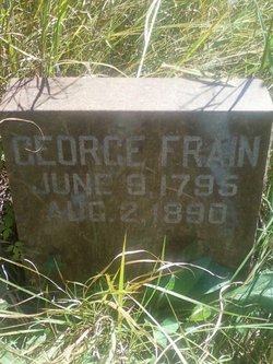

George Frain
| Birth | : | 9 Jun 1795 Chester County, Pennsylvania, USA |
| Death | : | 2 Aug 1890 Rochester, Cedar County, Iowa, USA |
| Burial | : | St. Mary the Virgin Churchyard, Henley-on-Thames, South Oxfordshire District, England |
| Coordinate | : | 51.5377790, -0.9017520 |
| Description | : | George was bound-out to a farmer in Limerick twp., Montgomery Co., PA to the age of 17 (about 1812). He then served in Conrad Krickbaum's 32nd Regiment of Pennsylvania Militia in Montgomery county during the War of 1812. He met his future wife at nearby Trappe while he lived in the Limerick area. After the war, in 1818, George married Mary Painter and he appeared on the tax list of Limerick from 1818 to 1822 as well as the 1820 Federal Census of Limerick. He wrote that his mother died in 1823 and that he then moved... Read More |
frequently asked questions (FAQ):
-
Where is George Frain's memorial?
George Frain's memorial is located at: St. Mary the Virgin Churchyard, Henley-on-Thames, South Oxfordshire District, England.
-
When did George Frain death?
George Frain death on 2 Aug 1890 in Rochester, Cedar County, Iowa, USA
-
Where are the coordinates of the George Frain's memorial?
Latitude: 51.5377790
Longitude: -0.9017520
Family Members:
Spouse
Children
Flowers:


Nearby Cemetories:
1. St. Mary the Virgin Churchyard
Henley-on-Thames, South Oxfordshire District, England
Coordinate: 51.5377790, -0.9017520
2. Christ Church
Henley-on-Thames, South Oxfordshire District, England
Coordinate: 51.5347880, -0.9032820
3. Holy Trinity Churchyard
Henley-on-Thames, South Oxfordshire District, England
Coordinate: 51.5338500, -0.9066600
4. St Margaret's Churchyard
Harpsden, South Oxfordshire District, England
Coordinate: 51.5219160, -0.9012270
5. Henley-on-Thames Cemetery
Henley-on-Thames, South Oxfordshire District, England
Coordinate: 51.5543570, -0.9271320
6. St. Nicholas' Churchyard
Rotherfield Greys, South Oxfordshire District, England
Coordinate: 51.5351017, -0.9541395
7. St. Mary the Virgin Churchyard
Fawley, Wycombe District, England
Coordinate: 51.5743000, -0.9140000
8. St. James's Churchyard
Bix and Assendon, South Oxfordshire District, England
Coordinate: 51.5610070, -0.9511270
9. St. Peter and St. Paul Churchyard
Shiplake, South Oxfordshire District, England
Coordinate: 51.4980750, -0.8963940
10. St Peter and St Paul Churchyard
Medmenham, Wycombe District, England
Coordinate: 51.5533800, -0.8407110
11. St. Mary's Churchyard
Wargrave, Wokingham Borough, England
Coordinate: 51.4998329, -0.8735808
12. Saint Mary the Virgin Churchyard
Hambleden, Wycombe District, England
Coordinate: 51.5773100, -0.8709500
13. All Saints Churchyard
Rotherfield Peppard, South Oxfordshire District, England
Coordinate: 51.5280531, -0.9725009
14. St. James' Old Churchyard
South Oxfordshire District, England
Coordinate: 51.5769360, -0.9532550
15. All Saints Churchyard
Dunsden Green, South Oxfordshire District, England
Coordinate: 51.4917730, -0.9461650
16. St. Pauls Highmoor Cross
Highmoor, South Oxfordshire District, England
Coordinate: 51.5532740, -0.9910110
17. St Mary the Virgin Churchyard
Hurley, Windsor and Maidenhead Royal Borough, England
Coordinate: 51.5492640, -0.8103620
18. Stonor Park Cemetery
Henley-on-Thames, South Oxfordshire District, England
Coordinate: 51.5967370, -0.9289660
19. St. Peter's Churchyard
Knowl Hill, Windsor and Maidenhead Royal Borough, England
Coordinate: 51.5093351, -0.8126725
20. St. Andrew's Churchyard
Sonning, Wokingham Borough, England
Coordinate: 51.4740300, -0.9131640
21. St Mary's Churchyard
Twyford, Wokingham Borough, England
Coordinate: 51.4763850, -0.8673190
22. St. John the Baptist Churchyard
Kidmore End, South Oxfordshire District, England
Coordinate: 51.5085170, -0.9951240
23. Kidmore End Cemetery
Kidmore End, South Oxfordshire District, England
Coordinate: 51.5071600, -0.9942160
24. St. Bartholomew's Churchyard
Nettlebed, South Oxfordshire District, England
Coordinate: 51.5752360, -0.9936230