
| Birth | : | 11 Jun 1918 Mineola, Mills County, Iowa, USA |
| Death | : | 11 Dec 2008 |
| Burial | : | Saint Pauls Lutheran Cemetery, Neola, Pottawattamie County, USA |
| Coordinate | : | 41.4337000, -95.7607000 |
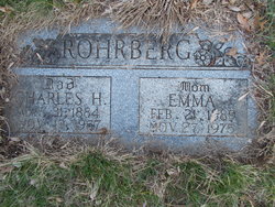
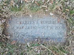
| Description | : | Georgia Flora Emma Bracker, age 90, went home to be with her Lord on Thursday December 11, 2008. Georgia was born June 11, 1918 in Mineola, Iowa to Charles and Emma Minssen Rohrberg. She graduated from Abraham Lincoln High School and married John "Joe" Bracker. Together they farmed and raised their children in the Boomer Township area. Georgia is a member of St. Paul's Lutheran Church, where she was active in the choir and ladies aid society. She loved to cook, bake, flowers and gardening, music, politics... Read More |
frequently asked questions (FAQ):
-
Where is Georgia Flora Emma Rohrberg Bracker's memorial?
Georgia Flora Emma Rohrberg Bracker's memorial is located at: Saint Pauls Lutheran Cemetery, Neola, Pottawattamie County, USA.
-
When did Georgia Flora Emma Rohrberg Bracker death?
Georgia Flora Emma Rohrberg Bracker death on 11 Dec 2008 in
-
Where are the coordinates of the Georgia Flora Emma Rohrberg Bracker's memorial?
Latitude: 41.4337000
Longitude: -95.7607000
Family Members:
Parent

Spouse

Siblings
Flowers:


Nearby Cemetories:
1. Saint Pauls Lutheran Cemetery
Neola, Pottawattamie County, USA
Coordinate: 41.4337000, -95.7607000
2. Grange Cemetery
Honey Creek, Pottawattamie County, USA
Coordinate: 41.4446678, -95.8034668
3. Reels Cemetery
Crescent, Pottawattamie County, USA
Coordinate: 41.4234100, -95.8321700
4. Castor Cemetery
Underwood, Pottawattamie County, USA
Coordinate: 41.4127040, -95.6887490
5. Saint Bridgets Cemetery
Honey Creek, Pottawattamie County, USA
Coordinate: 41.4664001, -95.8289032
6. William C McIntosh Cemetery
Crescent, Pottawattamie County, USA
Coordinate: 41.4088745, -95.8477097
7. Allen Cemetery
Pottawattamie County, USA
Coordinate: 41.4427986, -95.8550034
8. H G Fisher Cemetery
Underwood, Pottawattamie County, USA
Coordinate: 41.3838997, -95.6889038
9. Crook Cemetery
Honey Creek, Pottawattamie County, USA
Coordinate: 41.4581330, -95.8737000
10. Hazel Dell Cemetery
Council Bluffs, Pottawattamie County, USA
Coordinate: 41.3489723, -95.7939911
11. Branson Cemetery
Loveland, Pottawattamie County, USA
Coordinate: 41.4846992, -95.8606033
12. Saint Columbanus Cemetery
Weston, Pottawattamie County, USA
Coordinate: 41.3429440, -95.7435260
13. Downsville Cemetery
Pottawattamie County, USA
Coordinate: 41.3502998, -95.7039032
14. Crescent Cemetery
Crescent, Pottawattamie County, USA
Coordinate: 41.3664894, -95.8566208
15. Gregg Cemetery
Weston, Pottawattamie County, USA
Coordinate: 41.3330000, -95.7931000
16. Saint Patricks Cemetery
Neola, Pottawattamie County, USA
Coordinate: 41.4581300, -95.6183600
17. Neola Township Cemetery
Neola, Pottawattamie County, USA
Coordinate: 41.4591400, -95.6183800
18. Oak Grove Cemetery
Missouri Valley, Harrison County, USA
Coordinate: 41.5167007, -95.8649979
19. Evans Cemetery
Crescent, Pottawattamie County, USA
Coordinate: 41.3255997, -95.8368988
20. Linnwood Cemetery
Harrison County, USA
Coordinate: 41.5589200, -95.7502100
21. Pottawattamie County Home Cemetery
McClelland, Pottawattamie County, USA
Coordinate: 41.3269400, -95.6691738
22. Cox Cemetery
Persia, Harrison County, USA
Coordinate: 41.5391998, -95.6418991
23. Garner Cemetery
Council Bluffs, Pottawattamie County, USA
Coordinate: 41.2956161, -95.8001709
24. Jones - Williams Cemetery
Pottawattamie County, USA
Coordinate: 41.3761000, -95.5846000