
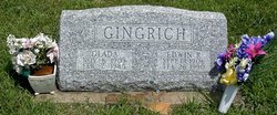
Glada Plank Gingrich
| Birth | : | 8 Nov 1903 Garden City, Cass County, Missouri, USA |
| Death | : | 7 Feb 1985 Harrisonville, Cass County, Missouri, USA |
| Burial | : | Christ Church Churchyard, Kilndown, Tunbridge Wells Borough, England |
| Coordinate | : | 51.0907820, 0.4269340 |
frequently asked questions (FAQ):
-
Where is Glada Plank Gingrich's memorial?
Glada Plank Gingrich's memorial is located at: Christ Church Churchyard, Kilndown, Tunbridge Wells Borough, England.
-
When did Glada Plank Gingrich death?
Glada Plank Gingrich death on 7 Feb 1985 in Harrisonville, Cass County, Missouri, USA
-
Where are the coordinates of the Glada Plank Gingrich's memorial?
Latitude: 51.0907820
Longitude: 0.4269340
Family Members:
Parent

Spouse

Siblings

Flowers:


Nearby Cemetories:
1. Christ Church Churchyard
Kilndown, Tunbridge Wells Borough, England
Coordinate: 51.0907820, 0.4269340
2. St Mary the Virgin Churchyard
Lamberhurst, Tunbridge Wells Borough, England
Coordinate: 51.1040459, 0.4012690
3. St Margarets Churchyard
Horsmonden, Tunbridge Wells Borough, England
Coordinate: 51.1169060, 0.4329730
4. Goudhurst War Memorial
Goudhurst, Tunbridge Wells Borough, England
Coordinate: 51.1129960, 0.4586850
5. St. Mary the Virgin Churchyard
Goudhurst, Tunbridge Wells Borough, England
Coordinate: 51.1136160, 0.4609480
6. Goudhurst Cemetery
Goudhurst, Tunbridge Wells Borough, England
Coordinate: 51.1134210, 0.4624930
7. Saint Augustine's Churchyard
Flimwell, Rother District, England
Coordinate: 51.0514170, 0.4580350
8. St. Mary's Churchyard
Ticehurst, Rother District, England
Coordinate: 51.0454030, 0.4077110
9. Bayham Old Abbey
Lamberhurst, Tunbridge Wells Borough, England
Coordinate: 51.1032690, 0.3541800
10. St. Peter & St. Paul Churchyard
Wadhurst, Wealden District, England
Coordinate: 51.0626960, 0.3400690
11. All Saints Churchyard
Brenchley, Tunbridge Wells Borough, England
Coordinate: 51.1504200, 0.4001200
12. St. Luke's Churchyard
Matfield, Tunbridge Wells Borough, England
Coordinate: 51.1426588, 0.3626785
13. St. Peter's Churchyard
Stonegate, Rother District, England
Coordinate: 51.0303090, 0.3747690
14. St Dunstan's Churchyard
Cranbrook, Tunbridge Wells Borough, England
Coordinate: 51.0973030, 0.5363690
15. St David's Bridge Strict Baptist Chapel
Cranbrook, Tunbridge Wells Borough, England
Coordinate: 51.0953430, 0.5378980
16. St. Laurence Churchyard
Hawkhurst, Tunbridge Wells Borough, England
Coordinate: 51.0377240, 0.5031610
17. Holy Trinity Churchyard
Hurst Green, Rother District, England
Coordinate: 51.0201400, 0.4691080
18. Hawkhurst Cemetery
Hawkhurst, Tunbridge Wells Borough, England
Coordinate: 51.0302300, 0.5051300
19. Cranbrook Cemetery
Cranbrook, Tunbridge Wells Borough, England
Coordinate: 51.0962250, 0.5541360
20. Assumption of Blessed Mary & St. Nicholas Church
Etchingham, Rother District, England
Coordinate: 51.0095830, 0.4416420
21. Pembury Burial Ground
Pembury, Tunbridge Wells Borough, England
Coordinate: 51.1416270, 0.3229290
22. St Peter's New Churchyard
Pembury, Tunbridge Wells Borough, England
Coordinate: 51.1506200, 0.3269600
23. Paddock Wood New Cemetery
Paddock Wood, Tunbridge Wells Borough, England
Coordinate: 51.1761499, 0.3980419
24. Sissinghurst Cemetery
Sissinghurst, Tunbridge Wells Borough, England
Coordinate: 51.1095310, 0.5629240