
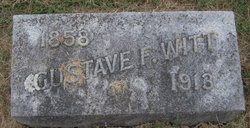
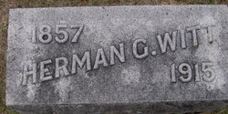
Gustave F Witt
| Birth | : | 18 Jun 1858 Mecklenburg-Vorpommern, Germany |
| Death | : | 17 Jul 1913 Syracuse, Otoe County, Nebraska, USA |
| Burial | : | Saint Andrew's Parish Churchyard, Skegby, Ashfield District, England |
| Coordinate | : | 53.1429900, -1.2661100 |
| Description | : | 7-25-1913, The Otoe Union: Mr. G.F. Witt died at his home in this city (Syracuse) last Thursday, July 17 at 6 o'clock p.m., aged 55 years and 29 days. He had been sick for several months and the second operation was performed that day, when death took him to a better world. The deceased was born at Mueckenburg, West Prussia, Germany, June 18, 1858 and came to this country and county in 1865. In 1882 he was confirmed in the Evangelical Lutheran faith by Rev. Neuman, and in 1884 he was married to Miss Adela Stutt,... Read More |
frequently asked questions (FAQ):
-
Where is Gustave F Witt's memorial?
Gustave F Witt's memorial is located at: Saint Andrew's Parish Churchyard, Skegby, Ashfield District, England.
-
When did Gustave F Witt death?
Gustave F Witt death on 17 Jul 1913 in Syracuse, Otoe County, Nebraska, USA
-
Where are the coordinates of the Gustave F Witt's memorial?
Latitude: 53.1429900
Longitude: -1.2661100
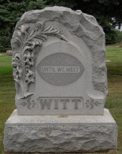
Family Members:
Parent

Spouse
Siblings
Children

Flowers:


Nearby Cemetories:
1. Saint Andrew's Parish Churchyard
Skegby, Ashfield District, England
Coordinate: 53.1429900, -1.2661100
2. St. Mary Magdalene Churchyard
Sutton-in-Ashfield, Ashfield District, England
Coordinate: 53.1255500, -1.2700820
3. Sutton Cemetery
Sutton-in-Ashfield, Ashfield District, England
Coordinate: 53.1238890, -1.2714690
4. St Michael Churchyard
Pleasley, Bolsover District, England
Coordinate: 53.1755900, -1.2469200
5. St. Peter's Churchyard
Mansfield, Mansfield District, England
Coordinate: 53.1434700, -1.1928900
6. St John the Baptist Churchyard
Ault Hucknall, Bolsover District, England
Coordinate: 53.1821350, -1.3021210
7. St. Wilfrid's Churchyard Extension
Kirkby-in-Ashfield, Ashfield District, England
Coordinate: 53.0975000, -1.2693400
8. St. John the Baptist Churchyard
Tibshelf, Bolsover District, England
Coordinate: 53.1431860, -1.3427080
9. Mansfield Cemetery
Mansfield, Mansfield District, England
Coordinate: 53.1250960, -1.1934520
10. Nottingham Road Cemetery
Mansfield, Mansfield District, England
Coordinate: 53.1270400, -1.1920500
11. Mansfield Crematorium
Mansfield, Mansfield District, England
Coordinate: 53.1214230, -1.1946980
12. St. Werburgh's Churchyard
Blackwell, Bolsover District, England
Coordinate: 53.1209850, -1.3380680
13. St. Edmund King & Martyr Churchyard Extension
Mansfield, Mansfield District, England
Coordinate: 53.1638200, -1.1900600
14. Kingsway Old Cemetery
Kirkby-in-Ashfield, Ashfield District, England
Coordinate: 53.0936690, -1.2427970
15. Kingsway New Cemetery
Kirkby-in-Ashfield, Ashfield District, England
Coordinate: 53.0917070, -1.2422500
16. St. Michael and All Angels Churchyard
South Normanton, Bolsover District, England
Coordinate: 53.1091020, -1.3411800
17. Tibshelf Parish Cemetery
Tibshelf, Bolsover District, England
Coordinate: 53.1379378, -1.3628144
18. St Alban the Martyr Churchyard
Forest Town, Mansfield District, England
Coordinate: 53.1524570, -1.1632350
19. St. Helen's Churchyard
Pinxton, Bolsover District, England
Coordinate: 53.0904510, -1.3243570
20. Heath Old Churchyard
Chesterfield Borough, England
Coordinate: 53.1990661, -1.3240162
21. Annesley and Felley
Annesley, Ashfield District, England
Coordinate: 53.0771910, -1.2407140
22. All Saints Church
Heath, North East Derbyshire District, England
Coordinate: 53.1986620, -1.3305840
23. All Saints Churchyard
Heath, North East Derbyshire District, England
Coordinate: 53.1988682, -1.3305255
24. Saint Leonard Churchyard
Scarcliffe, Bolsover District, England
Coordinate: 53.2139400, -1.2597200