
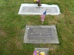

Harold C. “Hal” LaRoy
| Birth | : | 9 Feb 1921 |
| Death | : | 22 Aug 2007 |
| Burial | : | All Saints Churchyard, Kings Cliffe, East Northamptonshire Borough, England |
| Coordinate | : | 52.5622450, -0.5160080 |
| Inscription | : | CM3 US Coast Guard WORLD WAR II BELOVED HUSBAND & FATHER |
| Description | : | Harold C. LaRoy, beloved husband, father, grandfather and friend passed away August 22, 2007, of complications from alzeimer's. He was 86. Harold grew to be a strapping 6-foot-2-inch athlete who excelled at sports on the basketball court and baseball diamond. After graduating from Kalama High School, he served in the Coast Gusrd during World War II. Returning home, he played semi-professional baseball for the Cincinati Reds Farm Ateam and was wooed by baseball great Casey Stengel for a pro ball contract. Hal turned down the offer, preferring to be near his family. He and his wife Norene,... Read More |
frequently asked questions (FAQ):
-
Where is Harold C. “Hal” LaRoy's memorial?
Harold C. “Hal” LaRoy's memorial is located at: All Saints Churchyard, Kings Cliffe, East Northamptonshire Borough, England.
-
When did Harold C. “Hal” LaRoy death?
Harold C. “Hal” LaRoy death on 22 Aug 2007 in
-
Where are the coordinates of the Harold C. “Hal” LaRoy's memorial?
Latitude: 52.5622450
Longitude: -0.5160080
Family Members:
Parent

Siblings
Flowers:


Nearby Cemetories:
1. All Saints Churchyard
Kings Cliffe, East Northamptonshire Borough, England
Coordinate: 52.5622450, -0.5160080
2. Kings Cliffe Cemetery
Kings Cliffe, East Northamptonshire Borough, England
Coordinate: 52.5605586, -0.5102005
3. St Leonard Churchyard
Apethorpe, East Northamptonshire Borough, England
Coordinate: 52.5495140, -0.4899340
4. Holy Trinity Churchyard
Blatherwycke, East Northamptonshire Borough, England
Coordinate: 52.5514375, -0.5646654
5. St Mary Churchyard
Woodnewton, East Northamptonshire Borough, England
Coordinate: 52.5392210, -0.4795790
6. Church of St Mary
Duddington, East Northamptonshire Borough, England
Coordinate: 52.5969190, -0.5432540
7. St. Nicholas' Churchyard
Bulwick, East Northamptonshire Borough, England
Coordinate: 52.5376000, -0.5818000
8. Collyweston Cemetery
Collyweston, East Northamptonshire Borough, England
Coordinate: 52.6115580, -0.5319430
9. Church of Saint John the Baptist
Wakerley, East Northamptonshire Borough, England
Coordinate: 52.5817323, -0.5929850
10. Saint Mary the Virgin & All Saints Churchyard
Nassington, East Northamptonshire Borough, England
Coordinate: 52.5530000, -0.4332000
11. All Saints Churchyard
Laxton, East Northamptonshire Borough, England
Coordinate: 52.5535760, -0.5992450
12. St. Andrew's Churchyard
Collyweston, East Northamptonshire Borough, England
Coordinate: 52.6151719, -0.5303754
13. Nassington and Yarwell Cemetery
Yarwell, East Northamptonshire Borough, England
Coordinate: 52.5682373, -0.4263580
14. Yarwell Anglican and Methodist Church
Yarwell, East Northamptonshire Borough, England
Coordinate: 52.5671280, -0.4216160
15. St Mary the Virgin and All Saints Churchyard
Fotheringhay, East Northamptonshire Borough, England
Coordinate: 52.5258330, -0.4390740
16. St. Peter's Churchyard
Barrowden, Rutland Unitary Authority, England
Coordinate: 52.5888800, -0.6063600
17. Fotheringhay Castle
Fotheringhay, East Northamptonshire Borough, England
Coordinate: 52.5243170, -0.4363420
18. All Saints Churchyard
Wittering, Peterborough Unitary Authority, England
Coordinate: 52.6058600, -0.4421600
19. St Mary the Virgin Church
Wansford, Huntingdonshire District, England
Coordinate: 52.5805160, -0.4173890
20. Saint Peter's Churchyard
Deene, East Northamptonshire Borough, England
Coordinate: 52.5242490, -0.5984740
21. St Leonard's Churchyard
Glapthorn, East Northamptonshire Borough, England
Coordinate: 52.5001397, -0.4924849
22. Deene Park
Deene, East Northamptonshire Borough, England
Coordinate: 52.5242960, -0.6010350
23. Ketton Park Burial Ground
Ketton, Rutland Unitary Authority, England
Coordinate: 52.6240570, -0.5604330
24. Ketton St Mary the Virgin Churchyard
Ketton, Rutland Unitary Authority, England
Coordinate: 52.6274671, -0.5509559