| Birth | : | 24 Mar 1916 Le Mars, Plymouth County, Iowa, USA |
| Death | : | 29 May 1992 Le Mars, Plymouth County, Iowa, USA |
| Burial | : | Salem Cemetery, Rutherford, Gibson County, USA |
| Coordinate | : | 36.1217003, -88.9266968 |
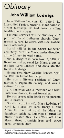
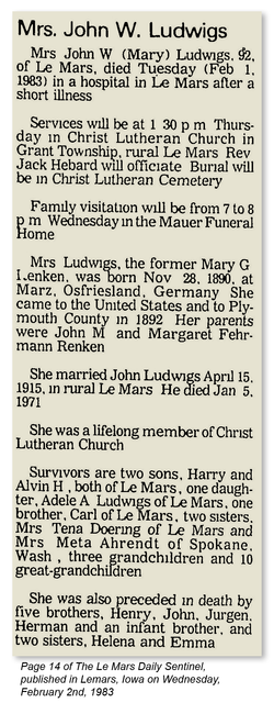
| Description | : | Harry J. Ludwigs, 76, of rural Le Mars died Friday, May 29, 1992, at his home. Services were Tuesday at Christ Lutheran Church, rural Le Mars. Rev. Jack Hebard officiated. Burial was in the church cemetery, under direction of Mauer-Johnson Funeral Home in Le Mars. Mr. Ludwigs was born March 24, 1916, at rural Le Mars to John W. and Mary (Renken) Ludwigs. He was born, raised and died in the same house. He married Lillian Jelken May 3, 1945; at St. John's Lutheran Church, Preston township. He farmed all his working life, retired in 1981 and continued... Read More |
frequently asked questions (FAQ):
-
Where is Harry J. Ludwigs's memorial?
Harry J. Ludwigs's memorial is located at: Salem Cemetery, Rutherford, Gibson County, USA.
-
When did Harry J. Ludwigs death?
Harry J. Ludwigs death on 29 May 1992 in Le Mars, Plymouth County, Iowa, USA
-
Where are the coordinates of the Harry J. Ludwigs's memorial?
Latitude: 36.1217003
Longitude: -88.9266968
Family Members:
Parent
Spouse
Siblings
Children
Flowers:
Nearby Cemetories:
1. Salem Cemetery
Rutherford, Gibson County, USA
Coordinate: 36.1217003, -88.9266968
2. China Grove Church Cemetery
Gibson County, USA
Coordinate: 36.1383018, -88.9113998
3. Beech Grove Cemetery
Rutherford, Gibson County, USA
Coordinate: 36.1591988, -88.9464035
4. Mount Zion Cemetery
Dyer, Gibson County, USA
Coordinate: 36.0936775, -88.8878403
5. Old Bluff Cemetery
Rutherford, Gibson County, USA
Coordinate: 36.1417870, -88.9751880
6. Antioch Methodist Cemetery
Bradford, Gibson County, USA
Coordinate: 36.1061400, -88.8737340
7. Antioch Cumberland Presbyterian Cemetery
Bradford, Gibson County, USA
Coordinate: 36.1050010, -88.8742630
8. Crockett Memorial Plot
Rutherford, Gibson County, USA
Coordinate: 36.1299620, -88.9871980
9. New Bethlehem Baptist Church Cemetery
Dyer, Gibson County, USA
Coordinate: 36.0715180, -88.9448400
10. New Bethlehem Memorial Cemetery
Dyer, Gibson County, USA
Coordinate: 36.0689090, -88.9452540
11. Hopper Cemetery
Dyer, Gibson County, USA
Coordinate: 36.0936200, -88.9878680
12. Rutherford Cemetery
Rutherford, Gibson County, USA
Coordinate: 36.1258011, -88.9989014
13. Apostolic Faith Tabernacle Cemetery
Dyer, Gibson County, USA
Coordinate: 36.0732460, -88.9674180
14. Walnut Grove Baptist Church Cemetery
Gibson County, USA
Coordinate: 36.1742000, -88.9606000
15. Keas Cemetery
Dyer, Gibson County, USA
Coordinate: 36.0769005, -88.9757996
16. Hillis Cemetery
Greenfield, Weakley County, USA
Coordinate: 36.1448870, -88.8524360
17. Bobbitt Cemetery
Dyer, Gibson County, USA
Coordinate: 36.0774994, -88.9850006
18. Poplar Grove Cemetery
Dyer, Gibson County, USA
Coordinate: 36.0574989, -88.9389038
19. Griffins Chapel United Methodist Church Cemetery
Gibson County, USA
Coordinate: 36.0793991, -88.8600006
20. New Victory MB Church Cemetery
Rutherford, Gibson County, USA
Coordinate: 36.1596780, -88.9978150
21. Keathley & Peel Family Cemetery
Gibson County, USA
Coordinate: 36.1651820, -88.9949470
22. Keeley Cemetery
Gibson County, USA
Coordinate: 36.0511017, -88.9175034
23. Cartwright Family
Dyer, Gibson County, USA
Coordinate: 36.0523510, -88.9001610
24. Carroll Cemetery
Rutherford, Gibson County, USA
Coordinate: 36.1453900, -89.0140800


