
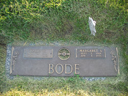
Harry W Bode
| Birth | : | 15 Apr 1905 |
| Death | : | 4 Nov 1970 |
| Burial | : | Wolvercote Cemetery, Oxford, City of Oxford, England |
| Coordinate | : | 51.7913666, -1.2721500 |
frequently asked questions (FAQ):
-
Where is Harry W Bode's memorial?
Harry W Bode's memorial is located at: Wolvercote Cemetery, Oxford, City of Oxford, England.
-
When did Harry W Bode death?
Harry W Bode death on 4 Nov 1970 in
-
Where are the coordinates of the Harry W Bode's memorial?
Latitude: 51.7913666
Longitude: -1.2721500
Family Members:
Parent

Spouse

Siblings
Children
Flowers:


Nearby Cemetories:
1. Wolvercote Cemetery
Oxford, City of Oxford, England
Coordinate: 51.7913666, -1.2721500
2. St. Peter Churchyard
Wolvercote, City of Oxford, England
Coordinate: 51.7848300, -1.2811100
3. St Michael and All Angels Summertown
Oxford, City of Oxford, England
Coordinate: 51.7796280, -1.2643940
4. Godstow Abbey Ruins
Oxford, City of Oxford, England
Coordinate: 51.7784060, -1.2998170
5. St. Bartholomew's Churchyard
Yarnton, Cherwell District, England
Coordinate: 51.8016610, -1.3087620
6. Yarnton Cemetery
Yarnton, Cherwell District, England
Coordinate: 51.8004080, -1.3103260
7. St. Nicholas Churchyard
Old Marston, City of Oxford, England
Coordinate: 51.7761340, -1.2373130
8. Saint Margaret of Antioch
City of Oxford, England
Coordinate: 51.7690340, -1.2975900
9. Elsfield Road Cemetery
Old Marston, City of Oxford, England
Coordinate: 51.7752940, -1.2332640
10. St. Sepulchres Cemetery
Oxford, City of Oxford, England
Coordinate: 51.7611110, -1.2694440
11. Wytham Churchyard
Wytham, Vale of White Horse District, England
Coordinate: 51.7736230, -1.3131610
12. Woodeaton Holy Rood Churchyard
Woodeaton, South Oxfordshire District, England
Coordinate: 51.8031620, -1.2257910
13. St Paul's Oxford Cemetery
Oxford, City of Oxford, England
Coordinate: 51.7594590, -1.2648470
14. St Giles Churchyard
Oxford, City of Oxford, England
Coordinate: 51.7591660, -1.2605170
15. Saint Barnabas Church
Oxford, City of Oxford, England
Coordinate: 51.7579620, -1.2697600
16. St Thomas of Canterbury Churchyard
Elsfield, South Oxfordshire District, England
Coordinate: 51.7858680, -1.2178310
17. Mansfield College Chapel
Oxford, City of Oxford, England
Coordinate: 51.7576410, -1.2523340
18. Blackfriars
Oxford, City of Oxford, England
Coordinate: 51.7561210, -1.2602060
19. St Johns College
Oxford, City of Oxford, England
Coordinate: 51.7560820, -1.2589910
20. Wadham College Chapel
Oxford, City of Oxford, England
Coordinate: 51.7560700, -1.2540350
21. Rewley Abbey
Oxford, City of Oxford, England
Coordinate: 51.7543810, -1.2675170
22. Martyrs' Memorial
Oxford, City of Oxford, England
Coordinate: 51.7550900, -1.2590100
23. Kidlington Burial Ground
Kidlington, Cherwell District, England
Coordinate: 51.8266010, -1.2916660
24. Trinity College Chapel
Oxford, City of Oxford, England
Coordinate: 51.7552360, -1.2569620