Hazel Phoebe Sackett Rutherford
| Birth | : | Aug 1893 Colusa County, California, USA |
| Death | : | 27 Feb 1912 Sacramento, Sacramento County, California, USA |
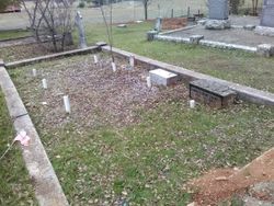
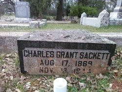
| Burial | : | El Dorado Cemetery, El Dorado, El Dorado County, USA |
| Coordinate | : | 38.6804085, -120.8490067 |
| Plot | : | sec 2 row 6 plot 24; Buried 3/1/1912 (per County Burial Permit; S. Silver, Sexton 1997-2002) |
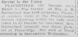
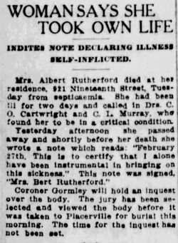
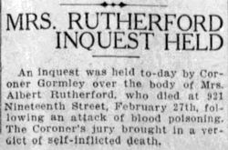
| Description | : | Phoebian died due to a failed abortion which caused her to bleed to death.∼The Mountain Democrat Placerville, California March 9, 1912 page 2 A Young Life Ended Mrs. A.B. Rutherford, formerly Hazel Phoebe Sackett, of this county, died at Sacramento, Feb. 25th, at noon, from blood poisoning, being sick only three or four days. The night before her death she was at the theatre with her husband, and only two weeks ago she visited her mother and father at Happy Valley, near Grizzly Flat, this county. She was a native of Colusa county and was 19 years, 6 months, and 9 days of age.... Read More |
frequently asked questions (FAQ):
-
Where is Hazel Phoebe Sackett Rutherford's memorial?
Hazel Phoebe Sackett Rutherford's memorial is located at: El Dorado Cemetery, El Dorado, El Dorado County, USA.
-
When did Hazel Phoebe Sackett Rutherford death?
Hazel Phoebe Sackett Rutherford death on 27 Feb 1912 in Sacramento, Sacramento County, California, USA
-
Where are the coordinates of the Hazel Phoebe Sackett Rutherford's memorial?
Latitude: 38.6804085
Longitude: -120.8490067
Family Members:
Parent
Flowers:
Nearby Cemetories:
1. El Dorado Cemetery
El Dorado, El Dorado County, USA
Coordinate: 38.6804085, -120.8490067
2. Kingsville Cemetery
El Dorado, El Dorado County, USA
Coordinate: 38.6993870, -120.8516060
3. Carpenter Family Residence Burial Plot
Diamond Springs, El Dorado County, USA
Coordinate: 38.6941590, -120.8187750
4. Diamond Springs Cemetery
Diamond Springs, El Dorado County, USA
Coordinate: 38.6940960, -120.8186620
5. Greenstone Cemetery
Shingle Springs, El Dorado County, USA
Coordinate: 38.6749020, -120.8869240
6. Odd Fellows Cemetery
Diamond Springs, El Dorado County, USA
Coordinate: 38.6963882, -120.8151932
7. Missouri Flat Cemetery
Placerville, El Dorado County, USA
Coordinate: 38.7157360, -120.8403400
8. Weberville Cemetery
Placerville, El Dorado County, USA
Coordinate: 38.7024170, -120.7901000
9. Heusner Ranch Family Cemetery
Buckeye, El Dorado County, USA
Coordinate: 38.6675770, -120.9135260
10. Meyer-Zentgraf Cemetery
Shingle Springs, El Dorado County, USA
Coordinate: 38.6710620, -120.9158490
11. Old Placerville City Cemetery
Placerville, El Dorado County, USA
Coordinate: 38.7258987, -120.8059464
12. Middletown Cemetery
Placerville, El Dorado County, USA
Coordinate: 38.7358704, -120.8301010
13. Old Saint Patricks Cemetery
Placerville, El Dorado County, USA
Coordinate: 38.7249107, -120.8024673
14. Westwood Hills Memorial Park Pet Cemetery
Placerville, El Dorado County, USA
Coordinate: 38.7365210, -120.8323130
15. Westwood Hills Memorial Park
Placerville, El Dorado County, USA
Coordinate: 38.7367363, -120.8326035
16. Jewish Pioneer Cemetery
Placerville, El Dorado County, USA
Coordinate: 38.7299500, -120.8091965
17. Boles Family Cemetery
Placerville, El Dorado County, USA
Coordinate: 38.7309860, -120.8069580
18. Placerville Union Cemetery
Placerville, El Dorado County, USA
Coordinate: 38.7317390, -120.8084106
19. Saint Patrick Cemetery
Placerville, El Dorado County, USA
Coordinate: 38.7327995, -120.8047638
20. Shingle Springs Cemetery
Shingle Springs, El Dorado County, USA
Coordinate: 38.6648903, -120.9270325
21. Frenchtown Cemetery
Frenchtown, El Dorado County, USA
Coordinate: 38.6421585, -120.9132309
22. Methodist Episcopal Federated Cemetery
Placerville, El Dorado County, USA
Coordinate: 38.7283287, -120.7942200
23. County Hospital Cemetery
Placerville, El Dorado County, USA
Coordinate: 38.7342796, -120.8028488
24. Cold Springs Cemetery
Cold Springs, El Dorado County, USA
Coordinate: 38.7441444, -120.8721619

