
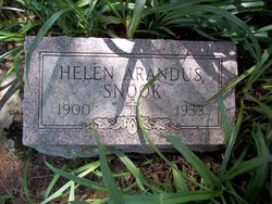
Helen Ethel Arandus Snook
| Birth | : | 13 May 1900 |
| Death | : | 4 Oct 1933 |
| Burial | : | St. Mary's Churchyard, Essendon, Welwyn Hatfield District, England |
| Coordinate | : | 51.7630460, -0.1561580 |
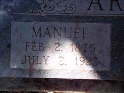
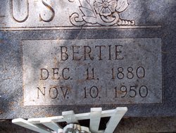
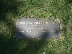
| Description | : | HELEN ETHEL ARANDUS SNOOK. MRS HELEN ARANDUS SNOOK, b: 1900 33 years old and the wife of AUBREY SNOOK Route 2 floris, Iowa died at the Sunnyslope Sanatorium this morning October 03, 1933. She is survived by her husband; Five Children, MIRIAM, DONALD, IRENE, GLADYS, and VIRGINIA ROSE. Her mother MRS BERTIE ARANDUS of Dahlonega, Iowa; One brother WILBER ARANDUS, and a sister GLADYS PONCY, both of Ottumwa, Iowa. Short funeral services will be held at the Johnson Funeral Chapel at 2:30 p.m. Friday and at 3 o'clock at the Davis Street Christian Church. The Rev. E.M. Boyer and the... Read More |
frequently asked questions (FAQ):
-
Where is Helen Ethel Arandus Snook's memorial?
Helen Ethel Arandus Snook's memorial is located at: St. Mary's Churchyard, Essendon, Welwyn Hatfield District, England.
-
When did Helen Ethel Arandus Snook death?
Helen Ethel Arandus Snook death on 4 Oct 1933 in
-
Where are the coordinates of the Helen Ethel Arandus Snook's memorial?
Latitude: 51.7630460
Longitude: -0.1561580
Family Members:
Parent
Spouse
Siblings

Children
Flowers:


Nearby Cemetories:
1. St. Mary's Churchyard
Essendon, Welwyn Hatfield District, England
Coordinate: 51.7630460, -0.1561580
2. St. Andrew's Churchyard
Little Berkhamsted, East Hertfordshire District, England
Coordinate: 51.7547390, -0.1295270
3. Saint Mary
Bayford, East Hertfordshire District, England
Coordinate: 51.7629540, -0.1035070
4. Hatfield Estate
Hatfield, Welwyn Hatfield District, England
Coordinate: 51.7606100, -0.2092010
5. St. Etheldreda Churchyard
Hatfield, Welwyn Hatfield District, England
Coordinate: 51.7614490, -0.2120150
6. St. Luke's Churchyard
Hatfield, Welwyn Hatfield District, England
Coordinate: 51.7643980, -0.2237710
7. St Mary Churchyard
Hertingfordbury, East Hertfordshire District, England
Coordinate: 51.7919480, -0.1043700
8. Welwyn Hatfield Lawn Cemetery
Welwyn Hatfield, Welwyn Hatfield District, England
Coordinate: 51.7422400, -0.2315670
9. Hertford Cemetery
Hertford, East Hertfordshire District, England
Coordinate: 51.8033280, -0.0979060
10. St Andrews Cemetery
Hertford, East Hertfordshire District, England
Coordinate: 51.8026720, -0.0951500
11. Saint Andrew Churchyard
Hertford, East Hertfordshire District, England
Coordinate: 51.7960550, -0.0823520
12. St John the Evangelist Churchyard
Lemsford, Welwyn Hatfield District, England
Coordinate: 51.7934510, -0.2355890
13. All Saints with Saint John Churchyard
Hertford, East Hertfordshire District, England
Coordinate: 51.7950040, -0.0757330
14. The Immaculate Conception and St Joseph
Hertford, East Hertfordshire District, England
Coordinate: 51.7988966, -0.0745293
15. St John the Evangelist Churchyard
Digswell, Welwyn Hatfield District, England
Coordinate: 51.8186190, -0.2051940
16. Holy Trinity Churchyard
Bengeo, East Hertfordshire District, England
Coordinate: 51.8053500, -0.0798610
17. St Michael and All Angels Churchyard
Waterford, East Hertfordshire District, England
Coordinate: 51.8152260, -0.0971940
18. St Andrew Church
Bramfield, East Hertfordshire District, England
Coordinate: 51.8241000, -0.1266000
19. St. Leonard's Churchyard
Bengeo, East Hertfordshire District, England
Coordinate: 51.8055165, -0.0722084
20. St. Mary's Churchyard
Potters Bar, Hertsmere Borough, England
Coordinate: 51.6926910, -0.1849770
21. Holy Trinity Churchyard
Hertford Heath, East Hertfordshire District, England
Coordinate: 51.7865300, -0.0433980
22. St Peter Churchyard
Ayot St Peter, Welwyn Hatfield District, England
Coordinate: 51.8201700, -0.2331800
23. St. Mary's Churchyard
Welwyn, Welwyn Hatfield District, England
Coordinate: 51.8311660, -0.2151400
24. St. Laurence Churchyard
Wormley, Broxbourne Borough, England
Coordinate: 51.7352050, -0.0389350