
| Birth | : | 19 Jul 1915 Weston, Pottawattamie County, Iowa, USA |
| Death | : | 20 Aug 2013 Council Bluffs, Pottawattamie County, Iowa, USA |
| Burial | : | Saint Pauls Lutheran Cemetery, Neola, Pottawattamie County, USA |
| Coordinate | : | 41.4337000, -95.7607000 |
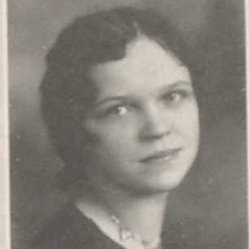
| Description | : | Helen Ruth Petersen, 98, of Council Bluffs, passed away August 20, 2013, at Bethany Lutheran Home. Helen was born on July 19, 1915, to Andrew and Karen (Hansen) Larson near Weston, Iowa. She was baptized and confirmed at St. Paul's Lutheran Church, Boomer Township. She graduated from Abraham Lincoln High School with the class of 1932, after which she taught school in Hazel Dell Township for one year. On August 28, 1935, she was united in marriage to Victor Petersen at St. Paul's Church. The Petersens farmed in the Council Bluffs, Neola and Walnut areas and also lived a number of years... Read More |
frequently asked questions (FAQ):
-
Where is Helen Ruth Larson Petersen's memorial?
Helen Ruth Larson Petersen's memorial is located at: Saint Pauls Lutheran Cemetery, Neola, Pottawattamie County, USA.
-
When did Helen Ruth Larson Petersen death?
Helen Ruth Larson Petersen death on 20 Aug 2013 in Council Bluffs, Pottawattamie County, Iowa, USA
-
Where are the coordinates of the Helen Ruth Larson Petersen's memorial?
Latitude: 41.4337000
Longitude: -95.7607000
Family Members:
Parent

Spouse
Siblings
Flowers:


Nearby Cemetories:
1. Saint Pauls Lutheran Cemetery
Neola, Pottawattamie County, USA
Coordinate: 41.4337000, -95.7607000
2. Grange Cemetery
Honey Creek, Pottawattamie County, USA
Coordinate: 41.4446678, -95.8034668
3. Reels Cemetery
Crescent, Pottawattamie County, USA
Coordinate: 41.4234100, -95.8321700
4. Castor Cemetery
Underwood, Pottawattamie County, USA
Coordinate: 41.4127040, -95.6887490
5. Saint Bridgets Cemetery
Honey Creek, Pottawattamie County, USA
Coordinate: 41.4664001, -95.8289032
6. William C McIntosh Cemetery
Crescent, Pottawattamie County, USA
Coordinate: 41.4088745, -95.8477097
7. Allen Cemetery
Pottawattamie County, USA
Coordinate: 41.4427986, -95.8550034
8. H G Fisher Cemetery
Underwood, Pottawattamie County, USA
Coordinate: 41.3838997, -95.6889038
9. Crook Cemetery
Honey Creek, Pottawattamie County, USA
Coordinate: 41.4581330, -95.8737000
10. Hazel Dell Cemetery
Council Bluffs, Pottawattamie County, USA
Coordinate: 41.3489723, -95.7939911
11. Branson Cemetery
Loveland, Pottawattamie County, USA
Coordinate: 41.4846992, -95.8606033
12. Saint Columbanus Cemetery
Weston, Pottawattamie County, USA
Coordinate: 41.3429440, -95.7435260
13. Downsville Cemetery
Pottawattamie County, USA
Coordinate: 41.3502998, -95.7039032
14. Crescent Cemetery
Crescent, Pottawattamie County, USA
Coordinate: 41.3664894, -95.8566208
15. Gregg Cemetery
Weston, Pottawattamie County, USA
Coordinate: 41.3330000, -95.7931000
16. Saint Patricks Cemetery
Neola, Pottawattamie County, USA
Coordinate: 41.4581300, -95.6183600
17. Neola Township Cemetery
Neola, Pottawattamie County, USA
Coordinate: 41.4591400, -95.6183800
18. Oak Grove Cemetery
Missouri Valley, Harrison County, USA
Coordinate: 41.5167007, -95.8649979
19. Evans Cemetery
Crescent, Pottawattamie County, USA
Coordinate: 41.3255997, -95.8368988
20. Linnwood Cemetery
Harrison County, USA
Coordinate: 41.5589200, -95.7502100
21. Pottawattamie County Home Cemetery
McClelland, Pottawattamie County, USA
Coordinate: 41.3269400, -95.6691738
22. Cox Cemetery
Persia, Harrison County, USA
Coordinate: 41.5391998, -95.6418991
23. Garner Cemetery
Council Bluffs, Pottawattamie County, USA
Coordinate: 41.2956161, -95.8001709
24. Jones - Williams Cemetery
Pottawattamie County, USA
Coordinate: 41.3761000, -95.5846000