
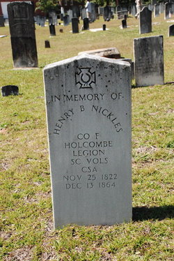
Henry Bryson Nickles
| Birth | : | 25 Nov 1822 |
| Death | : | 13 Dec 1864 St. Mary's County, Maryland, USA |
| Burial | : | St. Peter and St. Paul Churchyard, Barnham Broom, South Norfolk District, England |
| Coordinate | : | 52.6281830, 1.0749820 |
| Description | : | SUGGESTED ADDITIONAL INFORMATION In 1864, Henry Bryson Nickles serving as a Private in Company F, South Carolina Holcombe Legion Infantry Battalion, was captured and taken prisoner to Point Lookout at the southern tip of the Maryland Peninsula. During the Civil War Point Lookout was the home of one of the largest prisons for Confederate POWs; of the more than 52,000 prisoners incarcerated here, it is believed that over 14,000 died. Conditions in the prison was deplorable. Food was scarce, causing prisoners to eat rats and other dead animals. Malaria, scurvy, tuberculosis, caused many deaths. Overcrowding allowed viral diseases to spread quickly.... Read More |
frequently asked questions (FAQ):
-
Where is Henry Bryson Nickles's memorial?
Henry Bryson Nickles's memorial is located at: St. Peter and St. Paul Churchyard, Barnham Broom, South Norfolk District, England.
-
When did Henry Bryson Nickles death?
Henry Bryson Nickles death on 13 Dec 1864 in St. Mary's County, Maryland, USA
-
Where are the coordinates of the Henry Bryson Nickles's memorial?
Latitude: 52.6281830
Longitude: 1.0749820
Family Members:
Spouse
Children

Flowers:


Nearby Cemetories:
1. St. Peter and St. Paul Churchyard
Barnham Broom, South Norfolk District, England
Coordinate: 52.6281830, 1.0749820
2. St Mary's Churchyard
Carleton Forehoe, South Norfolk District, England
Coordinate: 52.6100400, 1.0847490
3. St Botolphs
Barford, South Norfolk District, England
Coordinate: 52.6287000, 1.1118000
4. All Saints Churchyard
Runhall, South Norfolk District, England
Coordinate: 52.6209876, 1.0390341
5. St. Andrew's Churchyard
Colton, South Norfolk District, England
Coordinate: 52.6407700, 1.1089300
6. All Saints Churchyard
Mattishall, Breckland Borough, England
Coordinate: 52.6498440, 1.0551390
7. All Saints, Welborne
South Norfolk District, England
Coordinate: 52.6496860, 1.0546670
8. All Saints Churchyard
East Tuddenham, Breckland Borough, England
Coordinate: 52.6602410, 1.0813620
9. St. Peter's Churchyard
Kimberley, South Norfolk District, England
Coordinate: 52.5958100, 1.0572070
10. All Saints' Churchyard
Mattishall, Breckland Borough, England
Coordinate: 52.6580670, 1.0346230
11. Mattishall cemetery
Mattishall, Breckland Borough, England
Coordinate: 52.6597100, 1.0353800
12. St. Mary's Churchyard
Marlingford, South Norfolk District, England
Coordinate: 52.6310660, 1.1416800
13. St Andrew's Churchyard
Honingham, Broadland District, England
Coordinate: 52.6573170, 1.1244600
14. St Peter's Church Mattishall Burgh
Mattishall, Breckland Borough, England
Coordinate: 52.6647174, 1.0396513
15. St Paul's Church Thuxton
Dereham, Breckland Borough, England
Coordinate: 52.6239060, 1.0013630
16. St. George's Churchyard
Hardingham, Breckland Borough, England
Coordinate: 52.6058090, 1.0040050
17. St. Michael's Churchyard
Hockering, Breckland Borough, England
Coordinate: 52.6771691, 1.0629078
18. St. Peter's Churchyard
Easton, South Norfolk District, England
Coordinate: 52.6543660, 1.1478070
19. St. Mary's Churchyard
North Tuddenham, Breckland Borough, England
Coordinate: 52.6753000, 1.0389600
20. St. Margaret's Churchyard
Garvestone, Breckland Borough, England
Coordinate: 52.6264200, 0.9889550
21. St. Mary's Churchyard
Deopham, South Norfolk District, England
Coordinate: 52.5788950, 1.0377920
22. All Saints & St Mary Churchyard
Great Melton, South Norfolk District, England
Coordinate: 52.6108700, 1.1602200
23. St. Peter's Churchyard
Reymerston, Breckland Borough, England
Coordinate: 52.6144500, 0.9827500
24. St. Mary and St. Walstan Churchyard
Bawburgh, South Norfolk District, England
Coordinate: 52.6327480, 1.1796530