
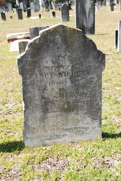
Nancy Agnes Hagan Nickles
| Birth | : | 8 Feb 1817 |
| Death | : | 12 Dec 1862 |
| Burial | : | St. Peter and St. Paul Churchyard, Barnham Broom, South Norfolk District, England |
| Coordinate | : | 52.6281830, 1.0749820 |
frequently asked questions (FAQ):
-
Where is Nancy Agnes Hagan Nickles's memorial?
Nancy Agnes Hagan Nickles's memorial is located at: St. Peter and St. Paul Churchyard, Barnham Broom, South Norfolk District, England.
-
When did Nancy Agnes Hagan Nickles death?
Nancy Agnes Hagan Nickles death on 12 Dec 1862 in
-
Where are the coordinates of the Nancy Agnes Hagan Nickles's memorial?
Latitude: 52.6281830
Longitude: 1.0749820
Family Members:
Parent

Spouse
Children

Flowers:


Nearby Cemetories:
1. St. Peter and St. Paul Churchyard
Barnham Broom, South Norfolk District, England
Coordinate: 52.6281830, 1.0749820
2. St Mary's Churchyard
Carleton Forehoe, South Norfolk District, England
Coordinate: 52.6100400, 1.0847490
3. St Botolphs
Barford, South Norfolk District, England
Coordinate: 52.6287000, 1.1118000
4. All Saints Churchyard
Runhall, South Norfolk District, England
Coordinate: 52.6209876, 1.0390341
5. St. Andrew's Churchyard
Colton, South Norfolk District, England
Coordinate: 52.6407700, 1.1089300
6. All Saints Churchyard
Mattishall, Breckland Borough, England
Coordinate: 52.6498440, 1.0551390
7. All Saints, Welborne
South Norfolk District, England
Coordinate: 52.6496860, 1.0546670
8. All Saints Churchyard
East Tuddenham, Breckland Borough, England
Coordinate: 52.6602410, 1.0813620
9. St. Peter's Churchyard
Kimberley, South Norfolk District, England
Coordinate: 52.5958100, 1.0572070
10. All Saints' Churchyard
Mattishall, Breckland Borough, England
Coordinate: 52.6580670, 1.0346230
11. Mattishall cemetery
Mattishall, Breckland Borough, England
Coordinate: 52.6597100, 1.0353800
12. St. Mary's Churchyard
Marlingford, South Norfolk District, England
Coordinate: 52.6310660, 1.1416800
13. St Andrew's Churchyard
Honingham, Broadland District, England
Coordinate: 52.6573170, 1.1244600
14. St Peter's Church Mattishall Burgh
Mattishall, Breckland Borough, England
Coordinate: 52.6647174, 1.0396513
15. St Paul's Church Thuxton
Dereham, Breckland Borough, England
Coordinate: 52.6239060, 1.0013630
16. St. George's Churchyard
Hardingham, Breckland Borough, England
Coordinate: 52.6058090, 1.0040050
17. St. Michael's Churchyard
Hockering, Breckland Borough, England
Coordinate: 52.6771691, 1.0629078
18. St. Peter's Churchyard
Easton, South Norfolk District, England
Coordinate: 52.6543660, 1.1478070
19. St. Mary's Churchyard
North Tuddenham, Breckland Borough, England
Coordinate: 52.6753000, 1.0389600
20. St. Margaret's Churchyard
Garvestone, Breckland Borough, England
Coordinate: 52.6264200, 0.9889550
21. St. Mary's Churchyard
Deopham, South Norfolk District, England
Coordinate: 52.5788950, 1.0377920
22. All Saints & St Mary Churchyard
Great Melton, South Norfolk District, England
Coordinate: 52.6108700, 1.1602200
23. St. Peter's Churchyard
Reymerston, Breckland Borough, England
Coordinate: 52.6144500, 0.9827500
24. St. Mary and St. Walstan Churchyard
Bawburgh, South Norfolk District, England
Coordinate: 52.6327480, 1.1796530