
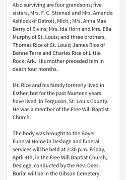
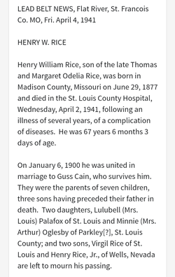
Henry William Rice
| Birth | : | 29 Jun 1877 Mine La Motte, Madison County, Missouri, USA |
| Death | : | 2 Apr 1941 Saint Louis, St. Louis City, Missouri, USA |
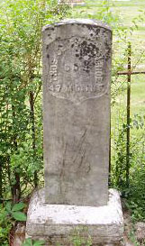
| Burial | : | Maple Hill Cemetery, Stoutsville, Fairfield County, USA |
| Coordinate | : | 39.6006012, -82.8227997 |
| Inscription | : | My Beloved Father |
| Description | : | Husband of Augusta Cain Married Feb. 6 1900 Missouri∼Henry's mother Margaret Brendle Rice died in a fire when he was very young. He was raised by his stepmother, Margaret Odelia Bone Rice. Henry married Augusta "Gussie" Cain on 6 Feb 1900 and they had 7 children. Note that the death certificate is incorrect in naming Henry's birthplace. |
frequently asked questions (FAQ):
-
Where is Henry William Rice's memorial?
Henry William Rice's memorial is located at: Maple Hill Cemetery, Stoutsville, Fairfield County, USA.
-
When did Henry William Rice death?
Henry William Rice death on 2 Apr 1941 in Saint Louis, St. Louis City, Missouri, USA
-
Where are the coordinates of the Henry William Rice's memorial?
Latitude: 39.6006012
Longitude: -82.8227997
Family Members:
Parent
Siblings

Children
Flowers:


Nearby Cemetories:
1. Maple Hill Cemetery
Stoutsville, Fairfield County, USA
Coordinate: 39.6006012, -82.8227997
2. Heidelberg Reformed Church Cemetery
Stoutsville, Fairfield County, USA
Coordinate: 39.6047783, -82.8269348
3. Wolf Cemetery
Stoutsville, Fairfield County, USA
Coordinate: 39.5901600, -82.8070200
4. Bunker Hill Cemetery
Stoutsville, Fairfield County, USA
Coordinate: 39.5855100, -82.8308600
5. Neff Cemetery
Stoutsville, Fairfield County, USA
Coordinate: 39.5821991, -82.8106003
6. Stout Family Cemetery
Washington Township, Pickaway County, USA
Coordinate: 39.6241989, -82.8439026
7. Spengler Cemetery
Stoutsville, Fairfield County, USA
Coordinate: 39.5653290, -82.8241650
8. Zion Cemetery
Circleville, Pickaway County, USA
Coordinate: 39.6119003, -82.8688965
9. Saint Pauls Evangelical Church Cemetery
Pickaway County, USA
Coordinate: 39.5925600, -82.8718400
10. Infirmary Cemetery
Pickaway County, USA
Coordinate: 39.6183014, -82.8675003
11. Dresbach Cemetery
Stoutsville, Fairfield County, USA
Coordinate: 39.5608978, -82.8262863
12. Mace Cemetery
Amanda, Fairfield County, USA
Coordinate: 39.6474710, -82.7978680
13. Old Conrad Cemetery
Amanda, Fairfield County, USA
Coordinate: 39.6153720, -82.7594120
14. Old Dutch Hollow Cemetery
Amanda, Fairfield County, USA
Coordinate: 39.6466410, -82.7908450
15. Conrad Cemetery
Amanda, Fairfield County, USA
Coordinate: 39.6156006, -82.7568970
16. Dutch Hollow Cemetery
Amanda, Fairfield County, USA
Coordinate: 39.6478004, -82.7897034
17. Bethany Cemetery
Circleville, Pickaway County, USA
Coordinate: 39.6437700, -82.8643000
18. Pontius Chapel Cemetery
Pickaway County, USA
Coordinate: 39.6009000, -82.8932300
19. Tarlton United Brethren Cemetery
Stoutsville, Fairfield County, USA
Coordinate: 39.5576530, -82.7792140
20. Walter Leist Farm Cemetery
Circleville, Pickaway County, USA
Coordinate: 39.6384060, -82.8743330
21. John Graffis Farm Cemetery
Circleville, Pickaway County, USA
Coordinate: 39.6280070, -82.8891730
22. Tarlton Cemetery
Tarlton, Pickaway County, USA
Coordinate: 39.5550630, -82.7737820
23. Emanuel Mennonite Church Cemetery
Amanda, Fairfield County, USA
Coordinate: 39.6171580, -82.7471100
24. Zinser Cemetery
Circleville, Pickaway County, USA
Coordinate: 39.6513090, -82.8660930